| | Thumbnail | | Creator | Date | Title / Author / Date / Location | Price | | | Description |
| 7907 |  | Details | Sebring Board of Trade | 1920 |
| Maps and Views of Sebring Florida |
|
Sebring Board of Trade |
|
| 1920 |
| LOC:500 |
| $350.00 | Sebring-Board-of-Trade | Maps-and-Views-of-Sebring-Florida | In 1920, just nine years after George E. Sebring acquired over 9,000 acres in the Florida Highlands to establish a new town, the Sebring Board of Trade published this substantial promotional pamphlet titled "Sebring, Florida. The City of Health and Happiness." By the time this brochure was circulated, Sebring's population had grown to around 3,000 residents. The historic downtown area of Sebring, which still reflects its 1920s origins, has been recognized as a Historic District on the National Register of Historic Places, acknowledging its significance and the enduring legacy of George E. Sebring's vision for the city.
<br><br>
The pamphlet is packed with text and photographs showcasing nearly every beneficial aspect of life in Sebring. The back cover features a bird's-eye view of the town encircling Lake Jackson, with "Twelve miles of velvet asphalt boulevard surrounding the Twilight Trail." Inside the front cover, another bird's-eye view depicts a fountain nestled among lush trees and meticulously landscaped formal gardens, described as "Sebring's beautiful little park around which the town revolves."
<br><br>
Within the pages, readers will find a map of peninsular Florida highlighting the area around Sebring, accompanied by a table displaying distances to various locations within the state. The pamphlet culminates with a pictorial map of the region immediately surrounding Sebring, illustrating the town's layout with the central park as its focal point, encircled by vast orange groves that stretch out into the surrounding countryside.
<br><br> |
| 7903 |  | Details | Green, Lewis Henry | 1913 |
| Early Plat of Royal Park Palm Beach Florida |
|
Green, Lewis Henry |
|
| 1913 |
| LOC:500 |
| $450.00 | Green--Lewis-Henry | Early-Plat-of-Royal-Park-Palm-Beach-Florida | Brochure (9" x 8") with a detailed plat of the Royal Park addition in Palm Beach, Florida. The Royal Park addition was one of the earliest planned developments in Palm Beach, Florida, developed starting around 1908, three years before Palm Beach was incorporated, in 1911. Royal Park was developed by Elisha Newton "Cap" Dimick, Palm Beach's first mayor, and early developers who had previously worked on the development of the Palm Beach Inn (later known as The Breakers hotel).
<br><br>
Dimick and his business partners marketed Royal Park as an exclusive residential community, featuring large lots, ocean to lake access, and Mediterranean Revival style architecture. In 1913, Lewis Henry Green, a wealthy Mexican-born real estate agent and investor from California, started working for the Royal Park subdivision in Palm Beach, Florida. He employed a game plan of splashy advertising, auctions, and prize giveaways for buyers. Green's dubbing of Royal Park as "the Millionaire's Playground" sparked significant interest in the development.
<br><br>
Tours of the "playground" were handled by W.E. Watson, a businessman who helped promote the project with two 24-seat vehicles that made the rounds. Green offered prizes daily at afternoon auctions held three days a week on Royal Palm Way, opposite the new bridge. At the first auction, 600 to 800 people attended, buying lots at around $375 each.
<br><br>
Royal Park sold out by 1917. Completed and settled a year later with eclectic bungalows, gabled Victorians, and front-porch cottages, the subdivision's burgeoning prominence would shift the town's center southward, paving the way for the 1920s dawn of Worth Avenue. |
| 6863 |  | Details | Requa | 1947 |
| Very Rare Attractions Map of Florida |
|
Requa |
|
| 1947 |
| LOC: |
| $200.00 | Requa | Very-Rare-Attractions-Map-of-Florida | Fine lithographed pictorial map of Florida highlighting its numerous attractions and State Parks. Seems to be very scarce and generally unavailable.
<br><br>
Several of the attractions on the map have either been sold to developers, renamed, or closed. These include:
<div class="indenttextblocksingle">
<ul style="list-style-type: circle;">
<li>McKee's Jungle Gardens</li>
<li>Turner's Sunken Gardens</li>
<li>Ringling Art Museum</li>
<li>Marineland</li>
<li>Ravine Gardens</li>
<li>Oriental Gardens (closed in 1954)</li>
<li>Dupree Gardens</li>
<li>Everglades Reptile Gardens (now Everglades Wonder Gardens)</li>
</ul>
</div>
Lithographed and published by Macdonald Publishers of Tampa, Florida in 1947 two years before the establishment of the Florida Attractions Association (1949). |
| 6856 |  | Details | Blissberger, Linda | 1982 |
| Coconut Grove Poster Advertising Map |
|
Blissberger, Linda |
|
| 1982 |
| LOC:61 |
| $525.00 | Blissberger--Linda | Coconut-Grove-Poster-Advertising-Map | Scarce advertising poster map of Coconut Grove, Florida by artist Linda Blissberger. 1982.
<br><br>
"Designed by the Blissberger with the able assistance of the Bliss Bear while dodging bulldozers on Florida Ave. Jan. - Feb. '82. Blissberger Art & Airbrush Creations & Gallery of Surprises. 3425c Main Hwy. 445-3146." |
| 6781 |  | Details | The Scenic Highlanders, Inc. | 1930 |
| Advertising Map Note Card for Florida's Scenic Highlands |
|
The Scenic Highlanders, Inc. |
|
| 1930 |
| LOC:14 |
| $75.00 | The-Scenic-Highlanders--Inc- | Advertising-Map-Note-Card-for-Florida-s-Scenic-Highlands | Florida ephemera advertising map / note card promoting Florida's Scenic Highlands. Produced by The Scenic Highlanders, Inc. Lake Wales, Florida (no online information is available about the firm). Florida's Scenic Highlands included the towns of Haines City, Lake Hamilton, Dundee, Lake of the Hills, Lake Wales, Highland Park, Babson Park, Frostproof, Avon Park, Sebring, and Lake Placid.
<br><br>
<div id="6781" align="center">
<a title=""></a>
<img id="6781" src="/ZoomifyImages/SC_6781/SC_6781_400x300.jpg" alt="Florida ephemera advertising map note card for Florida's Scenic Highlands." width="340"/> <br><br> <font size="-2">Florida Highland's Map</font>
</div><br>
Address for further contact "The Scenic Highlanders, Inc. Lake Wales, Florida" lacks a telephone number and an address code thus early. Undated but ca. 1925 - 1930. Statement at top of the maps urges the reader to "Make a note of Florida's Scenic Highlands 90 miles of hills, lakes, and orange groves." |
| 6765 |  | Details | St. Johns County Florida Chamber of Commerce | 1945 |
| St. Johns County blueprint style pictorial map |
|
St. Johns County Florida Chamber of Commerce |
|
| 1945 |
| LOC:89 |
| $220.00 | St--Johns-County-Florida-Chamber-of-Commerce | St--Johns-County-blueprint-style-pictorial-map | Scarce ephemera. Interesting blueprint style pictorial map of St. John's County on the east coast of Florida. Drawn by Sam Hubbard. Issued by the St. John's County Chamber of Commerce ca. 1945. A broadside, on a larger sheet with printing on both sides 23" x 14". Contains a cute compass rose incorporating a fishing rod into the graphic.
<br><br>
<div id="6765" align="center">
<a title=""></a>
<img id="6765" src="/ZoomifyImages/SC_6765/SC_6765_400x300.jpg" alt=blueprint style pictorial map of St. John's County, Florida ca, 1965." width="300"/> <br><br> <font size="-2">Broadside with map of St. John's County, Florida.</font>
</div><br> |
| 6710 | 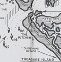 | Details | Allyn, Rube | 1960 |
| Rube Allyn's Fishing Map Boca Ciega Bay Clearwater 1B |
|
Allyn, Rube |
|
| 1960 |
| LOC:0 |
| $175.00 | Allyn--Rube | Rube-Allyn-s-Fishing-Map-Boca-Ciega-Bay-Clearwater-1B | DESCRIPTION: Original Rube Allyn's Authentic Fishing Map ca. 1960. for upper Boca Ciega Bay and Gulf Beaches. Locations and features that Allyn chose to include are: Clearwater Harbor, Reddington Beach, Upper Boca Ciega Bay, Madeira Beach, Long Bayou, Jungle Estates, Sunset Beach, Devil's Elbow, Blind Pass, and St. John's Pass.
<br></br>
Copyright Rube Allyn, St. Petersburg, Florida. Chart #1B. Drawn by Jack Meyer. |
| 6707 | 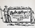 | Details | Allyn, Rube | 1960 |
| Allyns Fishing Map Hillsboro Bay 2B Tarpon |
|
Allyn, Rube |
|
| 1960 |
| LOC:0 |
| $165.00 | Allyn--Rube | Allyns-Fishing-Map-Hillsboro-Bay-2B-Tarpon | DESCRIPTION: Original Rube Allyn's Authentic Fishing Map (ca. 1960), for lower Hillsboro Bay south of St. Petersburg, Florida. Features include McKay Bay, Black Point, Gadsden Point, Coon Hammock Creek, the Kitchen, East Tampa, Alafia River, and Delaney Creek. Shows an astounding number of locations to catch Tarpon!
<br></br>
Map # 2B. ca. 1960. Copyright Rube Allyn, St. Petersburg, Florida. Research by Doc Howe. Drawn by Jack Meyer. |
| 6708 |  | Details | Allyn, Rube | 1960 |
| Allyns Fishing Map Lemon Bay 2G |
|
Allyn, Rube |
|
| 1960 |
| LOC:0 |
| $175.00 | Allyn--Rube | Allyns-Fishing-Map-Lemon-Bay-2G | DESCRIPTION: Original Rube Allyn's Authentic Fishing Map for Lemon Bay, Florida (ca. 1960). Drawn by Charlie Allyn and Barbara Hagerman. Points of interest include Gasparilla Sound, Coral Creek, Little Gasparillo Pass, Stump Pass, Stanford's Fishing Resort, Manasota Key, Englewood, and Alligator Creek.
<br></br>
Map # 2G. ca. 1960. Copyright Rube Allyn, St Petersburg, Florida. Great Outdoors Association. Pier 63, Central Basin, St. Petersburg, Florida. |
| 6709 |  | Details | Allyn, Rube | 1960 |
| Rube Allyn's Fishing Map Little Sarasota Bay Venice Florida 2F |
|
Allyn, Rube |
|
| 1960 |
| LOC:0 |
| $175.00 | Allyn--Rube | Rube-Allyn-s-Fishing-Map-Little-Sarasota-Bay-Venice-Florida-2F | DESCRIPTION: Original Rube Allyn's Authentic Fishing Map for the Little Sarasota Bay / Venice, Florida area. Key locations and features Allyn has noted include: Casey Key, Vamo, Osprey, Sarasota Beach, Midnight Pass, Tamiami Trail, Lyons Bay, and Roberts Bay. Perhaps the most interesting feature is a rock shelf (avg. depth 28 feet) that sinuously snakes its way just offshore the beach. Chart #2F.
<br></br>
Copyright Rube Allyn, St. Petersburg, Florida |
| 6690 |  | Details | Weinstock, Howard | 1971 |
| Exuberant Pictorial Map of Florida |
|
Weinstock, Howard |
|
| 1971 |
| LOC:68 |
| $550.00 | Weinstock--Howard | Exuberant-Pictorial-Map-of-Florida | Exuberant Pictorial Map of Florida dated within at 1971. Designed and illustrated by Howard Weinstock. Copyright 1971 United States Map Company. Los Angeles, California.
<br><br>
<div id="0" align="center">
<a title=""></a>
<img id="6690" src="/ZoomifyImages/SC_6690/SC_6690_detail.jpg" alt="Details of the Florida Keys from the exuberant Pictorial Map of Florida by Weinstock dated within at 1971 " width="330"/> <br><br> <font size="-2">The Florida Keys</font>
</div><br>
<div id="0" align="center">
<a title=""></a>
<img id="6690" src="/ZoomifyImages/SC_6690/SC_6690_detail_1.jpg" alt="Gulf coast details from the exuberant Pictorial Map of Florida by Weinstock dated within at 1971 " width="330"/> <br><br> <font size="-2">Florida Gulf Coast</font>
</div><br>
<div id="0" align="center">
<a title=""></a>
<img id="6690" src="/ZoomifyImages/SC_6690/SC_6690_detail_2.jpg" alt="The Sun from the exuberant Pictorial Map of Florida by Weinstock dated within at 1971 " width="330"/> <br><br> <font size="-2">A happy Florida Sun</font>
</div><br> |
| 6689 |  | Details | Colonial Land Company | 1925 |
| Pinewood Florida |
|
Colonial Land Company |
|
| 1925 |
| LOC:86 |
| $285.00 | Colonial-Land-Company | Pinewood-Florida | Plat for a development- "Pinewood" in Fort Pierce, Florida, 1925. Shows usage in the real-estate trade by the presence of manuscript color probably to track sales of each lot. Streets include the New Dixie Highway / South Fourth Street, Indian River Drive, Georgia Avenue, Park Way, Coconut Drive, Sunrise Boulevard and many more.
<br><br>
At bottom sample elevation profiles of trendy 1920's Florida bungalows (1).
<br><br>
The neighborhood was owned and developed by Colonial Land Company of Trenton, N. J. with offices in Fort Pierce and West Palm Beach, Florida. Robb & Buchanan, Engineers. Fort Pierce, Florida. Dated within at June 8, 1925 and signed by N. C. Buchanan.
<br><br>
<div id="0" align="center">
<a title=""></a>
<img id="6689" src="/ZoomifyImages/SC_6689/SC_6689_detail_2.jpg" alt="Bungalows on a 60' street cross section for a development- "Pinewood" in Fort Pierce, Florida, by Colonial Land Company in 1925." published by Seaboard Airline Railway Florida." width="320"/> <br><br> <font size="-2">Bungalows at Pinewood. A 60' street cross section.</font>
</div><br>
(1) The bungalow is a type of housing unit that emerged in the late 19th century. It is a one-story or one-and-a-half-story house that is typically small in size and has a low-pitched roof with wide eaves that often extend to form a porch.
<br><br>
In the United States, the bungalow style became popular in the early 20th century, particularly in the western states where it was seen as a way to adapt to the climate and terrain of the region. Bungalows were often built in neighborhoods where land was relatively cheap and could be subdivided into small lots. The bungalow style continued to evolve throughout the 20th century, with many variations and adaptations, including the California bungalow, the Chicago bungalow, and the Craftsman bungalow. |
| 6653 | 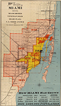 | Details | A.C. Douglass Printing Company | 1926 |
| 1926 Map of the City of Miami and Environs with Estimated Expansion |
|
A.C. Douglass Printing Company |
|
| 1926 |
| LOC:89 |
| $600.00 | A-C--Douglass-Printing-Company | 1926-Map-of-the-City-of-Miami-and-Environs-with-Estimated-Expansion | Interesting and prescient original lithographed map of the City of Miami and the nearby surrounding area made during the Miami land boom. The map shows forecasted expansive development between the period 1925 - 1935. Scarce.
<br><br>
Show Miami's historic growth from 1910 - 1925 and forecasts development to 1935 with projected future boundaries shown. Miami's boundary shows rapid population growth from 5,470 people in 1910, to 29,571 in 1920, and 225,000 in 1926, with the population projected to reach 1,000,000 by 1935.
<br><br>
Compiled and drawn by Sauer and Seghy. Printed by A.C. Douglass Printing Co., (2907 N.W. 12th Ave., Miami) in 1926.
<br><br>
Along with the usual suspects the map captures several lesser known historical features:
<div class="indenttextblocksingle">
<ul style="list-style-type: circle;">
<li>Irons Manor subdivision: The Irons Manor development was platted by developer V. Earl Irons in 1926 following the principles of the City Beautiful movement. </li>
<li>Miami Jockey Club: established in 1924 by James Bright, Glenn Curtis, and Joseph Smoot. </li>
<li>Hanson's avocado grove established by Edgar F. Hanson in 1922 was the largest in the world with over 30,000 avocado trees.</li>
<li>King Cole Hotel, with 60 rooms was completed in 1925.</li>
<li>Future site of the University of Miami, opened in fall 1926.</li>
</ul>
</div> |
| 6648 |  | Details | Seaboard Air Line Railway | 1917 |
| Military Camps Winter Resorts Map Florida |
|
Seaboard Air Line Railway |
|
| 1917 |
| LOC:150 |
| $800.00 | Seaboard-Air-Line-Railway | Military-Camps-Winter-Resorts-Map-Florida | Rare patriotic WWI map titled "Military Camps and Nearby Resorts. Winter Near Your Soldier Boy." This fine 31 inch long antique map was published by Seaboard Airline Railway in 1917. Outstanding and emotionally evocative graphics on the cover with a fine thematic promotional map on the recto.
<br><br>
<div id="0" align="center">
<a title=""></a>
<img id="6648" src="/ZoomifyImages/SC_6648/SC_6648_cover_detail.jpg" alt="WWI map titled "Military Camps and Nearby Resorts. Winter Near Your Soldier Boy" published by Seaboard Airline Railway Florida." width="100"/> <br><br> <font size="-2">Military Resorts Cover Art</font>
</div><br>
Only one holding is found in WorldCat, at Rutgers. WorldCat's mildly cynical one-line summary of the map reads <b>"War as a tourist industry for elegant ladies & gentlemen."</b> (1)
<br><br>
This full-size folding map shows twenty-eight locations (Army, Navy, and Aero training camps) served by the Seaboard Air Line Railway where a spouse (wife) could travel to spend the winter holidays with her soldier (husband) during 1917, the fourth year of WWI. The camps and stations of the U.S. Army were indicated with red square symbols, those of the Navy with circles, and Aero Stations by triangles. The U.S. Army Air Service, as it was then called, was established after April, 1917 making this map one of the earliest available maps to show Pensacola as an Naval Air Training Station.
<br></br>
These Army, Navy, and Aero training locations, described in the key at bottom right, include Pensacola, Tampa, and Key West, Florida; New Orleans, Louisiana; Charleston, South Carolina; and Port Royal, SC.
<br></br>
Brochure folds to 4" x 9". Printed by Poole Brothers, Chicago and dated within at 8/16/1917.
<br><br>
(1) WorldCat. Online. Accessed: January, 2023 |
| 6626 |  | Details | Casey-toons | 1997 |
| Pictorial View of Jacksonville Florida Skyline and Jaguars Stadium |
|
Casey-toons |
|
| 1997 |
| LOC:150 |
| $500.00 | Casey-toons | Pictorial-View-of-Jacksonville-Florida-Skyline-and-Jaguars-Stadium | 1997 glossy advertising-oriented poster- a view of the Jacksonville, Florida skyline with a focus on the Jacksonville Jaguars NFL-team stadium, surrounded by Jaguars. Copyright Jacksonville, Jaguars LTD 1997. Produced and distributed by Casey-Toons , II, Inc. An official team illustration.
<br><br>
Above the stadium float blimp-like footballs containing blank scoreboards with the names and date of upcoming Jaguars football games.
<br><br>
Dedicated to Dave and signed in ink by Casey 4-29-97.
<BR><BR>
Includes numerous Jaguars. Here a Jaguar, there a Jaguar. Everywhere ... |
| 6627 |  | Details | Banana, Joe | 1992 |
| Official Souvenir Map of Treasure Island Florida Pictorial |
|
Banana, Joe |
|
| 1992 |
| LOC:150 |
| $350.00 | Banana--Joe | Official-Souvenir-Map-of-Treasure-Island-Florida-Pictorial | Tourist-oriented pictorial map of coastal Treasure Island, Florida titled "Official Souvenir Map of Treasure Island Florida". Published 1992. Copyright 1993 by Joe Banana Enterprises.
<br><br>
An advertising-supported map designed and illustrated entirely by Joe Banana. Margins include text describing the Treasure Island area with statistics, information about the beaches and the educational institution Admiral Farragut Academy (AFA), a preparatory and boarding school. Among the facts in the margins is a statement that the map took Banana over 300 hours to draw and color. |
| 6553 | 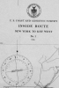 | Details | U.S. Coast and Geodetic Survey | 1916 |
| 8 Charts Inside Route New York to Key West or ICWW 1916 |
|
U.S. Coast and Geodetic Survey |
|
| 1916 |
| LOC:300 |
| $585.00 | U-S--Coast-and-Geodetic-Survey | 8-Charts-Inside-Route-New-York-to-Key-West-or-ICWW-1916 | Very scarce and complete set of eight U.S. Coast and Geodetic Survey folding navigational charts for the inside route for maritime traffic on the eastern coast of the United States from New York South. Third edition. These historical charts from 1916 predate the U.S. Government's ownership of the route which later became part of the Intracoastal Waterway (ICWW) . Placed end to end, the charts would extend over 18 feet long.
<br><br>
Includes the 94 page Coast Survey Sailing Directions that once housed the 8 charts in an attached interior envelope. Card cover. Binding intact. Price when issued was 20 cents.
<BR> </BR>
A bit of research shows that in its early history some portions of the inside route were owned and dredged by private entities who charged a toll to vessels for passage, sometimes by stringing a chain across narrow passages to restrict traffic flow. In fact, chart 7 contains manuscript pencil annotations, obviously made during a voyage, of "Toll" and "Toll chain" that reflects that little-known fact. Interestingly, the toll chains are not noted as part of the official chart. After 1919 Congress mandated that the entire passage should be turned over to the Federal government and the tolls were eliminated.<BR> </BR>
Size of each chart when folded is approximately 8" x 5". These 8 lithographed working navigational charts capture the full extent of the eastern U.S. inside route in detail with some manuscript pencil annotations, especially in Florida. Chart sections include roughly these areas and chart sizes: (one dimension is typically 10" and the other dimension is below). <BR>
1. Jersey City to Philadelphia - 10" <BR>
2. Philadelphia to Norfolk - 33" <BR>
3. Norfolk to Cape Lookout - 28" <BR>
4. Cape Lookout to Murphy Island - 31" <BR>
5. Murphy Island to Fernandina - 35" <BR>
6. Fernandina to Cape Canaveral -28" <BR>
7. Cape Canaveral to Miami -32" <BR>
8. Miami to Key West - 24" <BR> |
| 6538 | 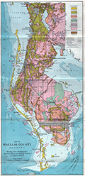 | Details | Weston, T.W. | 1919 |
| Map of Pinellas County Florida with Fishing Grounds |
|
Weston, T.W. |
|
| 1919 |
| LOC:300 |
| $250.00 | Weston--T-W- | Map-of-Pinellas-County-Florida-with-Fishing-Grounds | Colorful lithographed map (8" x 16") of Pinellas County, Florida in 1919 by T.W. Weston issued in a folding 4" x 9" brochure by the Pinellas County Board of Trade. In addition to the Pinellas County map, the brochure includes a fine small oblique birds-eye view - "Dunedin - a typical coast town" (Fig 1.), a small regional distance chart extending for 1500 miles from Pinellas County (Fig 2.), descriptive text, and numerous photographs. <br><br>
<div id="1" align="center">
<a title="Dunedin, Florida Birds-eye View"></a>
<img id="1" src="/ZoomifyImages/SC_6538/SC_6538_Detail1.jpg" alt="Dunedin, Florida 1919 Birds-eye View" width="320"/> <br><small>Fig. 1 - 1919 Birds-eye View of Dunedin, Florida.</small>
</div><br>
The Pinellas County map shows soil type (coastal beach, Parkwood loam, tidal marsh …) indicated by color overlaid with routes of steam railroads, electric railways, three types of roads, canals, and drainage districts.
<br><br>
<div id="2" align="center">
<a title="Pinellas County Distance Chart"></a>
<img id="2" src="/ZoomifyImages/SC_6538/SC_6538_Detail2.jpg" alt="Distance chart related to Pinellas County Florida." width="250"/> <br><small>Fig. 2 - Statute mile distances from Pinellas County.</small>
</div><br>
Red font denotes species of fish found around Pinellas County (Fig. 3) These fish include tarpon, trout, channel bass (redfish), mackerel, and kingfish.<br><br>
<div id="3" align="center">
<a title="Pinellas County Fish Species"></a>
<img id="3" src="/ZoomifyImages/SC_6538/SC_6538_Detail3.jpg" alt="Detail from Pinellas County Map." width="250"/> <br><small>Fig. 3 - Detail of Pinellas County fish species.</small>
</div> |
| 6526 |  | Details | Skacel, Bill | 1946 |
| Pictorial Cartoon map of Florida Bill Skacel |
|
Skacel, Bill |
|
| 1946 |
| LOC:300 |
| $200.00 | Skacel--Bill | Pictorial-Cartoon-map-of-Florida-Bill-Skacel | Original, scarce pictorial map of the State of Florida by artist Bill Skacel ca. 1946. The humorous, historical cartoon map of Florida was produced ca. 1946 as a folded nine-panel tourist-oriented mailer with the verso containing space for an address as well as facts and photos of Florida
<br><br> |
| 6452 |  | Details | Utz, Thornton | 1965 |
| 60s Pictorial map of Sarasota Florida |
|
Utz, Thornton |
|
| 1965 |
| LOC:87 |
| $300.00 | Utz--Thornton | 60s-Pictorial-map-of-Sarasota-Florida | Pictorial map of Sarasota, Florida and surrounding areas ca. 1965. Designated the Official Chamber of Commerce map, it shows a single span of the old Sunshine Skyway bridge. Copyrighted and published by Thornton Utz as the Limited Gift Edition, this printing of Utz's Map of Sarasota was presented as a service by the Sarasota bank and Trust Company.
<br><br>
<div id="1" align="center">
<a title="Sarasota Florida Pictorial Map"></a>
<img id="3" src="/ZoomifyImages/SC_6452/SC_6452_Detail.jpg" alt="1960s Pictorial Map of Sarasota, Florida by Utz" width="340"/> <br><small>Detail from Utz's Map of Sarasota, Florida</small>
</div><br>
Utz included sketches of numerous commercial and recreational activities in his map including:
<div class="indenttextblocksingle">
<ul style="list-style-type: circle;"></li>
<li>Siesta Key and Longboat Key</li>
<li>Sarasota Jungle Gardens</li>
<li>Chicago White Sox training camp</li>
<li>Bradenton Art Center</li>
<li>Camp Flying Eagle Boy Scout camp</li>
<li>Crescent Beach and Lido Beach</li>
<li>Forest Lakes County Club</li>
<li>Ringling Museum</li>
</ul>
</div>
Based on the $3.00 price stated for an mail-order autographed copy of the map, it appears to predate the version of the map held at the Touchton Map Library which carries a $5.00 price and lacks the reference in the title cartouche to Sarasota Bank and Trust. |
| 6423 | 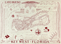 | Details | Suchy, Arthur Bartholomew | 1941 |
| Cayo Hueso or Key West Florida Second Edition |
|
Suchy, Arthur Bartholomew |
|
| 1941 |
| LOC:87 |
| $375.00 | Suchy--Arthur-Bartholomew | Cayo-Hueso--or-Key-West-Florida-Second-Edition | Stunning original second-edition pictorial birds-eye map of Cayo Hueso or Key West, Florida. Printed as designed in red ink. Designed, executed, produced and copyrighted by Arthur Suchy ca. 1941. Excellent detail on over 70 key locations that Suchy identifies alphabetically and numerically on a key that surrounds the view including:
<div class="indenttextblocksingle">
<ul style="list-style-type: circle;"></li>
<li>Cigar factories</li>
<li>P.A.A. Airport</li>
<li>Turtle crawls</li>
<li>Fish market</li>
<li>Warbler (helpful tug)</li>
<li>Pepe's coffee shop</li>
<li>Delmonico's</li>
<li>Key West radio station</li>
</ul>
</div>
Arthur Bartholomew Suchy (1901 - 1995) produced two editions of his famous map of Cayo Hueso- the first edition, larger and with full hand color was produced in a limited edition of 100 copies dated to 1940 and the second and smaller edition printed in red ink to 1941. [1] Includes numerous historical notes about Key West.
<br><br>
Suchy was issued a copyright for the collectors edition on Dec. 14, 1938. He filed a renewal application on Nov. 17, 1966.
<br><br>
[1] David Rumsey Map Collection at Stanford University Libraries |
| 6367 |  | Details | Leisen, Theodore | 1949 |
| Theodore Leisen Pictorial Map of Key West Florida |
|
Leisen, Theodore |
|
| 1949 |
| LOC: |
| $225.00 | Leisen--Theodore | Theodore-Leisen-Pictorial-Map-of-Key-West-Florida | Scarce medium-format pictorial map of Key West, Florida by Theodore Leisen Jr. The map of Key West map is undated but ca. 1949 based on Leisen's population estimate of 20,000 at publication. The population of Key West in 1950 is recorded as 21,792 persons excluding military personnel [1].
<br></br>
The map / brochure published by the Key West Chamber of Commerce contains a legend with numerous points of interest in Key West. Recto with map of the "World Famous Overseas Highway" from Key Largo to Key West. Key West translates to Cayo Hueso in Spanish.
<br></br>
[1] Wilkinson, Jerry. History of Key West. Online: http://www.keyshistory.org/keywest.html |
| 6361 |  | Details | U.S. Coast and Geodetic Survey | 1914 |
| Key West Harbor 1914 |
|
U.S. Coast and Geodetic Survey |
|
| 1914 |
| LOC: |
| $1,000.00 | U-S--Coast-and-Geodetic-Survey | Key-West-Harbor-1914 | Large 42" x 34" U.S. Coast Survey chart of Key West Harbor, Florida . Issued September 1914 by the U.S. Department of Commerce / U.S. Coast Survey. Number 584. A scarce original nautical chart of Key West at 107 years old. Last date is 1914. |
| 6348 |  | Details | s. w. artz inc. | 1998 |
| Key West Map Poster with street legend |
|
s. w. artz inc. |
|
| 1998 |
| LOC:61 |
| $200.00 | s--w--artz-inc- | Key-West-Map-Poster-with-street-legend | Late 20th Century Poster of Key West, Florida by s. w. artz, inc. Copyright 1998 by s. w. artz, inc. as "The Complete Map and Legend of Key West." Map with an inset legend of street names.
<br></br>
Key locations include:<br />
<div class="indenttextblocksingle">
<ul style="list-style-type: circle;">
<li>Wisteria Island</li>
<li>Christmas Tree Island</li>
<li>Fleming Key</li>
<li>Thompson Island</li>
<li>Fort Zachary Taylor State Park</li>
<li>Mallory Square</li>
<li>Simonton Beach</li>
</ul>
</div> |
| 6340 |  | Details | Johnson, W.R. | 1955 |
| Plan of the Atomic Tunnel 1950's attraction near Daytona Beach |
|
Johnson, W.R. |
|
| 1955 |
| LOC:11 |
| $199.00 | Johnson--W-R- | Plan-of-the-Atomic-Tunnel-1950-s-attraction-near-Daytona-Beach | Lithographed plan / view of the <i>"World's Most Unusual</i> Atomic Tunnel". A four-panel <strong>Florida roadside-attraction</strong> brochure from the early 1950s. An atomic age wonder! The illustrator is unknown but his interpretation of Happy the Walking Fish is a high point in mid-century illustration with Happy dressed to the nines in bow tie, top hat, and tuxedo and carrying a cane.
<div class="indenttextblocksingle">
" … it was a long, white concrete building in the shape of a meandering tube, studded with 824 "port holes" (variously shaped small windows) that was designed primarily as a showcase and shop for exotic orchids. It also featured tropical birds, a monkey, and "Happy, the walking fish," a typical Southeast Asian "walking" catfish that could be prodded into flipping its way across a short dry connection from one tank to another." (1)
</div>
<BR />
<div id="1" align="center">
<a title="Atomic Tunnel">
<img id="TunnelPlan" src="/ZoomifyImages/SC_6340/SC_6340_Happy_400x300.jpg" alt="Atomic Tunnel" width="240"
/>
</a>
</div>
<div id="2" align="center">
<a title="Atomic Tunnel">
<img id="TunnelPlan" src="/ZoomifyImages/SC_6340/SC_6340_400x300.jpg" alt="Atomic Tunnel" width="300"
/>
</a>
</div>
<br />
<u>Verso</u> contains two reverse-profile portraits of "Happy, the Walking Fish" and also two fold-in panels showing a map and plan of the Atomic Tunnel with happy visitors strolling along walkways. The illustrator cleverly uses two different levels of scale on this work, at top a linear representation with mile boards of HWY 1 stretching from Daytona Beach, Florida through Port Orange to the Atomic Tunnel and below on the same page a plan view of the Atomic Tunnel's tunnels, rooms and walkways at a large scale. The <u>recto</u> shows detailed photographs of the rooms including the Fish room, Bird room and Cactus room. |
| 6327 |  | Details | Trudeau, Garry B. | 2005 |
| Signed Key West poster by cartoonist Garry Trudeau |
|
Trudeau, Garry B. |
|
| 2005 |
| LOC:87 |
| $355.00 | Trudeau--Garry-B- | Signed-Key-West-poster-by-cartoonist-Garry-Trudeau | Rare limited edition poster by Doonesbury cartoonist Garry Trudeau (1948 - ) promoting the 23rd Annual Key West Literary Seminar, Humor: January 6 - 16, 2005. Number 58 of 100 issued. Signed and numbered by Trudeau.
<br></br>
In 1975 Garry Trudeau became the first comic strip artist to win a Pulitzer Prize, an honor usually awarded to editorial page cartoonists. |
| 6329 |  | Details | Allyn, Rube | 1960 |
| Allyn's Fishing Map 2E Sarasota Bay |
|
Allyn, Rube |
|
| 1960 |
| LOC:61 |
| $135.00 | Allyn--Rube | Allyn-s-Fishing-Map-2E-Sarasota-Bay | Original Rube Allyn's Authentic Fishing Map (ca. 1960), for Sarasota Bay, Florida. Key features include Sister Key, Sleepy Lagoon, Dream Island, Buttonwood Harbor, Longboat Key, Sarasota, Ringling Isles and Big Sarasota Pass.
<br></br>
Map # 2E. Ca. 1960. Copyright Rube Allyn, St. Petersburg, Florida. Lithographed by MacDonald, Tampa. |
| 5493 |  | Details | Dornbush, Adrian | 1935 |
| Public Works of Art Project brochure variant 2nd Edition map Coral Isle of Key West |
|
Dornbush, Adrian |
|
| 1935 |
| LOC:11 |
| $325.00 | Dornbush--Adrian | Public-Works-of-Art-Project-brochure-variant-2nd-Edition-map-Coral-Isle-of-Key-West | Two scarce maps including a rare presumed 2nd. "The Coral Isle of Key West" Florida in a visitor's guide booklet simply titled "Key West" published by the Key West Administration after 1935. The booklet is a product of the Public Works of Art Project (PWAP) during the New Deal that was succeeded by the Federal Art Project of the Works Progress Administration (WPA).
<div class="indenttextblocksingle">
"Public Works of Art Project artists from other parts of the country were brought in and put to work creating paintings, murals or public places, and other projects, such as tourist brochures and postcards." [1]
</div><br>
<div id="3" align="center">
<a title="Key West Booklet"></a>
<img id="3" src="/ZoomifyImages/SC_5493/SC_5493_Cover_400x300.jpg" alt="Dornbush pictorial map The Coral Isle of Key West." width="240"/>
</div>
<br />
Other FERA artists who contributed works to the brochure include Edward Bruce, Richard Sargeant, Avery Johnson, Klir Beck, and Richard Jansen.<br>
</br>
The brochure includes a fine 9" x 6" pictorial map of Key West, Florida: "The Coral Isle of Key West" by artist Adrian Dornbush, 1935. Second edition. This map is most interesting in that it is an <b>unrecorded substantial revision of Dornbush's original map of Key West.</b> This edition contains numerous changes from the first edition including:
<div class="indenttextblocksingle">
<ul>
<li>For the first time, an airport is noted in the location of Meacham Field, now Key West International Airport (EYW)</li>
<li>Seaplane ramps at Trumbull Point (labeled "Key West Airways") are replaced with ship docks. </li>
<li>Radio towers are now shown located at the island's west side near Duval Street.</li>
</ul>
</div>
The map was engraved on a "miraculous" scale and shows key landmarks such as Duval Street, the lighthouse, the Martello Towers, and the yacht basin.
<br></br> |
| 5047 |  | Details | Dornbush, Adrian | 1935 |
| Depression era pictorial brochure 1st Edition map The Coral Isle of Key West |
|
Dornbush, Adrian |
|
| 1935 |
| LOC:300 |
| $300.00 | Dornbush--Adrian | Depression-era-pictorial-brochure-1st-Edition-map-The-Coral-Isle-of-Key-West | Two scarce maps of Key West, Florida in a visitor's guide booklet simply titled "Key West" published by the Key West Administration in 1935. The booklet is a product of the Public Works of Art Project (PWAP) during the New Deal that was succeeded by the Federal Art Project of the Works Progress Administration (WPA).
<div class="indenttextblocksingle">
"Public Works of Art Project artists from other parts of the country were brought in and put to work creating paintings, murals or public places, and other projects, such as tourist brochures and postcards." [1]
</div>
</br>
The brochure includes a fine 1st edition pictorial map (9" x 6") of Key West, Florida: "The Coral Isle of Key West" by artist Adrian Dornbush, 1935. The map (first edition) was engraved on a "miraculous" scale and shows key landmarks such as Duval Street, the lighthouse, the Martello Towers, and the yacht basin. Other FERA artists who contributed works to the brochure include Edward Bruce, Richard Sargeant, Avery Johnson, Klir Beck, and Richard Jansen.
<br></br>
At center of the brochure is an anonymous two-sheet "Map of the Lower Florida Keys or the Key West Archipelago" (18" x 6") containing a smaller inset map of the Caribbean region.
<br></br>
Printed by Orange Publishing Co. St. Cloud, Florida.
<br></br>
[1] https://keysarts.com/public_art/wpa.html <br>
[2] <a href="https://www.rarecharts.com/ShowDetail/Creator/Dornbush--Adrian/Title/Depression-era-pictorial-brochure-with-variant-2nd-Edition-map-Coral-Isle-of-Key-West/5493" target="_blank">See the second edition here.</a> |
| 5461 |  | Details | Grant, John A. Jr. | 1988 |
| Official City Map of Lighthouse Point, Florida |
|
Grant, John A. Jr. |
|
| 1988 |
| LOC: |
| $650.00 | Grant--John-A--Jr- | Official-City-Map-of-Lighthouse-Point--Florida | Official City Map of <strong>Lighthouse Point, Florida</strong> prepared by John A. Grant Jr. Registered Land Surveyor 1141 State of Florida. The map was prepared in 1960 and later adopted in 1964. This edition is dated to 1988. No copy is found online.
<br></br>
The seaside community of Lighthouse Point is a suburb of Fort Lauderdale located in northeastern Broward County, Florida, United States. Lighthouse Point was named for the Hillsboro Inlet Lighthouse (map bottom right), located in Hillsboro Beach. In 2010 the population of Lighthouse Point was 10,344.
<br></br>
This map is hand colored to highlight neighborhood names and is colored by hand to represent the local zoning district. Pasted typed and hand-colored paper <strong>zoning legend</strong> at left provides an index to the zoning district designation by color. These districts in 1988 were:
<div class="indenttextblocksingle">
<ul style="list-style-type: circle;">
<li>RM-25 Apartment Districts</li>
<li>RM-16 4-Family Residence</li>
<li>RD-10 2-Family Residence</li>
<li>RS-3 Single Family Residence</li>
<li>B-3 Single Family Residence</li>
<li>B-3A Special Business Districts</li>
<li>B-3 General Business Districts</li>
<li>B-2A Planned Business Districts</li>
<li>B-2 Community Business Districts</li>
<li>B-1 Neighborhood Special Business Districts</li>
</ul>
</div>
<br></br>
Map, matted and framed with plexiglass glazing. Total overall size is 26" W x 37" H.
<br></br>
Price includes packing and shipping, insurance, within the Continental USA. Not shipped internationally due to size. |
| 5450 |  | Details | F.A. Bennett | 1925 |
| Rare view Fairyland Point Fleetwood Hotel Ormond-on-the-Bay and Muriel Estates |
|
F.A. Bennett |
|
| 1925 |
| LOC: |
| $350.00 | F-A--Bennett | Rare-view-Fairyland-Point-Fleetwood-Hotel-Ormond-on-the-Bay-and-Muriel-Estates | Rare, unrecorded antique 1920's panoramic birds-eye view of Ormond-on-the-Bay and Muriel Estates, Florida with the Fleetwood Hotel. Photograph of a painting showing Ormond-on-the-Bay and Muriel Estates both promoted by F.A. Bennett Developments. Inset of the Fleetwood Hotel. Probably a postal card. Framed.
<br></br>
The Fleetwood Hotel was a planned 300-room 15-story resort hotel with a casino, tennis courts, pool, ballroom on what is now part of Tomoka State Park. The Fleetwood Hotel, promoted by a developer called "Commodore" J. Perry Stoltz, was to embody the luxury and decadence synonymous with the Roaring Twenties.
<br></br>
[1] Jarmusz, T.S. Did Ormond Beach pillars mark a fantasy hotel that never materialized?. Daytona Beach News-Journal. January 7, 2009. Accessed Online. |
| 5444 |  | Details | U.S. Coast and Geodetic Survey | 1920 |
| Chart of the St. Johns River in Florida From Hibernia to Racy Point 1900 1920 |
|
U.S. Coast and Geodetic Survey |
|
| 1920 |
| LOC:56 |
| $750.00 | U-S--Coast-and-Geodetic-Survey | Chart-of-the-St--Johns-River-in-Florida-From-Hibernia-to-Racy-Point-1900-1920 | Nautical chart of a section of the St. Johns River Florida from Hibernia southward to Racy Point. Hibernia, Florida lies about 22 miles southwest of downtown Jacksonville, on the western side of the St. Johns River, off US 17. Racy Point lies on the east bank of the St. John's River about four miles northwest of Hastings, Florida and 12 miles from Palatka.
<br></br>
Published by the U.S. Coast and Geodetic Survey October, 1900. Reissued December, 1916. Last corrections April, 1920. Chart # 455c. Price when issued was 40 cents. |
| 5443 |  | Details | U.S. Coast and Geodetic Survey | 1914 |
| Scarce antique chart of Key West Harbor and Approaches |
|
U.S. Coast and Geodetic Survey |
|
| 1914 |
| LOC: |
| $1,440.00 | U-S--Coast-and-Geodetic-Survey | Scarce-antique-chart-of-Key-West-Harbor-and-Approaches | A scarce 107 year-old chart of Key West Harbor and its approaches in Florida. A nice example, scarce to find with process color from this era.
<br></br>
Published by the US Coast and Geodetic Survey in 1914, the chart shows Whitehead spit, east and west Martello Tower, Raccoon Key, and Stock Island. Coverage extends to the west as far as Boca Grande Key. Chart # 584. Price when issued was 50 cents. |
| 5399 | 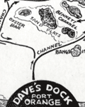 | Details | Michaels, Lawrence | 1947 |
| Map of the Halifax River Port Orange Florida Dave's Dock |
|
Michaels, Lawrence |
|
| 1947 |
| LOC:11 |
| $195.00 | Michaels--Lawrence | Map-of-the-Halifax-River-Port-Orange-Florida-Dave-s-Dock | Rare map of the Halifax River area near Port Orange, Florida ca. 1947. The map is on the verso of a folding postal card featuring Dave's Dock (currently Aunt Catfish's since ca. 1979), about five miles south of Daytona, Florida. Unfolds to 3.5" x 11".
<br></br>
In addition to channels and fishing areas, noted features on the chart include:
<div class="indenttextblocksingle">
<ul style="list-style-type: circle;">
<li>Location of the old Port Orange Bridge.</li>
<li>Pelican Island</li>
<li>Freeman Oyster bar</li>
<li>Rose Bay</li>
<li>Wilbur Bay</li>
<li>Daggett's Island</li>
<li>Peter Johnson's Point</li>
<li>Fozzard, Sutton, Sharpe's and Mill's Creeks</li>
<li>Half Dollar Island</li>
</ul>
</div>
Dave’s Dock was built before 1938. Lawrence “Mike” Michaels, bought Dave’s Dock in the mid 1940's and retained ownership until 1959. Front of the card shows fishing and pleasure boats tied up at Dave's 600' long dock and a Coca Cola sign on the front of the office.
<br></br>
Name the owner was modified to read " L. Michaels" on the camera-ready copy by a quick 'copy and paste' before printing. That must mean that this is a second edition of Dave's Dock card. The scene shown may reflect a much earlier date, perhaps as early as 1938 when the dock was first built. |
| 5390 |  | Details | English, Robert B. | 1936 |
| Unrecorded maps on development of Florida counties 1831 to 1935 WPA |
|
English, Robert B. |
|
| 1936 |
| LOC:11 |
| $240.00 | English--Robert-B- | Unrecorded-maps-on-development-of-Florida-counties-1831-to-1935-WPA | Original photostat copy of a document with a time-series of ten maps on the development, boundaries, and naming of counties in the State of Florida from 1831 to 1935. White print on black background. Contains detailed textual data on Dade County including population and historical notes. With documentation of the sources for information about Dade County.
<br></br>
Unrecorded. No copy of this document is found online. Assembled by the Historical Records Survey and the State Archives survey- local office, District 3, 3041 Grand Avenue, Coconut Grove, Florida. Dr. Robert B. English, Compiler. Natalie Newell, del. October 1, 1936. WPA.
<br></br>
A substantially different version of this work from 1936, covering the years 1820 - 1936 is attributed to the Works Progress Administration, Florida. That version, from a single online source appears at https://www.floridamemory.com/items/show/322986. |
| 5386 | 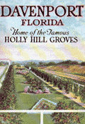 | Details | Holly Hill Grove and Fruit Company | 1923 |
| Fine brochure for Holly Hill Groves Davenport Florida with maps and views |
|
Holly Hill Grove and Fruit Company |
|
| 1923 |
| LOC:11 |
| $240.00 | Holly-Hill-Grove-and-Fruit-Company | Fine-brochure-for-Holly-Hill-Groves-Davenport-Florida-with-maps-and-views | Fine brochure for Holly Hill Groves in Davenport, Polk County, Florida with a map, views, and numerous 2-color photographs.
<br>
<div class="indenttextblocksingle">1) A colorful view titled "<b>Diagram of Holly Hills Groves</b>" . With an inset view "A Five Acre Grove". 18" W x 6.5" H.<br>
2) An index or context map shows the location of Davenport, Florida in the center of the state. "<b>Map of Florida Showing Location of Davenport and Polk County."</b> 6.5" W x 9" H.</div>
Photos are of the orange groves in various states of completion as well as of the Holly Grove Inn, located along the Dixie Highway. Published during the early 1920's during Florida's real estate boom.
<br></br>
The Holly Hill Grove and Fruit Company, with over 5,000 acres, was a subsidiary of Wilson and Toomer Fertilizer Company, owned by Lorenzo A. Wilson. The brochure was published as a marketing tool to promote sales of five-acre plots of the grove. <br></br>
32 pages. Soft covers. Folds to 5" W x 7" H. Printed by The Record Company, St. Augustine, Florida.
<br></br> |
| 5387 | 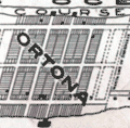 | Details | Simpson and Pope | 1925 |
| Map and marketing brochure for Ortona, Florida |
|
Simpson and Pope |
|
| 1925 |
| LOC:11 |
| $150.00 | Simpson-and-Pope | Map-and-marketing-brochure-for-Ortona--Florida | Scarce sales brochure ca. 1925 for the Ortona, Florida development located on Florida's east coast in Volusia County just south of Ormond, Florida. Cover of the brochure shows several cottages and bungalows built in the Ortona neighborhood in the early 1920's. Note: this location is NOT the town of Ortona, Florida in Glades County.
<br></br>
The map shows Ortona bounded at the west by the Halifax River and at the east by the [Daytona] Auto Race Course on the beach. To the south, in 1925 Ortona was bounded by the "Clarendon Golf Links" and Seabreeze. The towns of Seabreeze, Daytona Beach, and Daytona are shown as platted and developed.
<br></br>
TITLE: "Ortona, On the Finest Ocean Beach in America, For Your Winter Home". Single sheet, folded. |
| 5383 | 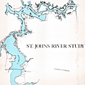 | Details | Jacksonville Area Planning Board | 1977 |
| St. Johns River Corridor Plan with St. Johns River Study |
|
Jacksonville Area Planning Board |
|
| 1977 |
| LOC: |
| $500.00 | Jacksonville-Area-Planning-Board | St--Johns-River-Corridor-Plan-with-St--Johns-River-Study | Scarce <b>three-panel map</b> of the St. Johns River Corridor Plan in Duval County, Florida (accompanies the Study). The map contains summary recommendations and observations made by the Jacksonville Area Planning Board in their 1977 Study of the St. Johns River. Map 30" W x 10" H. Verso blank.
<br></br>
The planning study by the Jacksonville Area Planning Board (JAPD), is a 174-page environmental and urban study of the 39-mile extent of the St. Johns River found in Duval County, Florida: the <b>St. Johns River Corridor</b>. The study contains over 40 detailed large-scale, sectional geographic maps and thematic maps for land use along the St. Johns River Corridor (e.g. Military, Recreational). Light card cover.
<br></br>
Based on an analysis of five environmental factors the JAPD recommended land usage-intensity levels. They proposed design guidelines, development and improvement proposals, and program recommendations for 21 sections of shoreline along the corridor. Maps incorporate their findings.
<br></br>
Copy of Lynwood Roberts, then President of the Jacksonville City Council. With separate typed transmittal letter from the JAPD to Roberts. |
| 5377 |  | Details | London Magazine | 1762 |
| Antique engraved Plan of the Straights of Bahama |
|
London Magazine |
|
| 1762 |
| LOC:13 |
| $325.00 | London-Magazine | Antique-engraved-Plan-of-the-Straights-of-Bahama | Original antique engraved map of the route taken by the British Fleet during their attack on the city of Havana, Cuba in 1762.
<br></br>
The map depicts the fleet's passage through the Old Bahamas Channel, a risky route just north of Cuba, through a channel only 10 miles wide at some points. The route taken by the British reduced the amount of warning time afforded to the Spanish Fleet.
<br></br>
Conducted during the Seven Years' War, the Siege of Havana was a successful British siege against Spanish-ruled Havana that lasted from March to August 1762.
<br></br>
"A Plan of the Straights of Bahama, through which the Expedition Fleet was Conducted in the Year 1762 against the Havana". Engraved for the London Magazine. Published from London by Baldwin in January 1763. |
| 5379 | 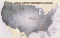 | Details | General Electric | 1964 |
| Map of General Electric support locations for Apollo Space Program |
|
General Electric |
|
| 1964 |
| LOC:55 |
| $275.00 | General-Electric | Map-of-General-Electric-support-locations-for-Apollo-Space-Program | Rare unrecorded map of locations in the United States for teams created by General Electric Corporation to provide engineering services to the Apollo Spaceflight Program- the "Apollo Support Department" (ASD) in the mid 1960s.
<br></br>
Two of the Apollo Support Department's seven locations are located in Florida; the headquarters in Daytona Beach, and another in Cocoa Beach, Florida. Other ASD locations included Houston, Texas; Huntsville, Alabama; Syracuse, New York; and Washington, D.C. The ASD was part of the Command Systems Division of G.E.
<br></br>
No copies of this map are found online.
<br></br>
Verso with signature: "M. Williams". |
| 5380 | 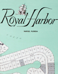 | Details | Royal Palm Harbor, Inc. | 1960 |
| Naples, Florida sales plat for Royal Harbor subdivision |
|
Royal Palm Harbor, Inc. |
|
| 1960 |
| LOC:90 |
| $250.00 | Royal-Palm-Harbor--Inc- | Naples--Florida-sales-plat-for-Royal-Harbor-subdivision | Scarce lithographed plat of lots for sale during 1960 in the Royal Harbor subdivision of Naples, Florida. The shaded areas consist of lots sold before October 1, 1960.
<br></br>
Originally developed in the 1960’s-1970’s, Royal Harbor is a waterfront community consisting of over 600 plus single family homes and condominiums located on the Eastern shore of Naples Bay. Royal Harbor is located near the heart of Naples, across the bay from Port Royal.
<br></br>
Published by Royal Palm Harbor, Inc. 1650 Curlew Avenue Naples Florida. |
| 5348 |  | Details | Anonymous | 1806 |
| Original antique Ben Franklins Chart of the Gulf Stream |
|
Anonymous |
|
| 1806 |
| LOC:11 |
| $275.00 | Anonymous | Original-antique-Ben-Franklins-Chart-of-the-Gulf-Stream | Decorative antique chart of the Gulf Stream with the Florida East and West Territories. After Benjamin Franklin's original chart, first engraved by James Poupard, published by the American Philosophical Society in 1786.
<br></br>
This chart lacks the written <b>sailing directions</b> in Poupard's engraving or "Remarks upon the navigation from Newfoundland to New York in order to avoid the Gulph Stream on the one hand, and on the other the Shoals that lie to the southward of Nantucket and of St. George's Banks." In those remarks, Franklin notes the time savings mariners can achieve through avoiding the Gulf Stream when westbound from England to the USA :
<div class="indenttextblocksingle">
"The Nantucket captains who are acquainted with this stream, make their voyages from England to Boston in as short a time generally as others take in going from Boston to England, viz. from 20 to 30 days."
</div>
</br>
Source: The Complete Works on Philosophy, Politics and Morals of the Late Dr. Benjamin Franklin, 2nd ed, London 1806. Plate VII. Vol 2. p. 197. Published by Longman, Hurst, Rees, and Orme. London, April 1, 1806. |
| 5334 |  | Details | National Aeronautics and Space Administration | 1966 |
| NASA glossy publicity photo of J . F. K. Space Center map |
|
National Aeronautics and Space Administration |
|
| 1966 |
| LOC:11 |
| $100.00 | National-Aeronautics-and-Space-Administration | NASA-glossy-publicity-photo-of-J---F--K---Space-Center-map | An original NASA unclassified glossy black and white publicity photograph of a NASA birdseye view map of the John F. Kennedy Space Center and the surrounding area in eastern and central Florida. Dated on verso to 8/8/66.
<br></br>
The photograph shows a map, apparently tacked to a bulletin board, ranging in coverage as far as Orlando, Oak Hills, and Eau Galle, Florida. Key points of interest shown include: McCoy Air Force Base, Patrick Air Force Base, Cocoa Beach, the St. Johns River, Indian River, Banana River, and Mosquito Inlet. At the lower left corner is a key or context map showing the location of the map relative to the entire state of Florida.
<br></br>
When the photo was published in August, 1966 NASA was winding down the last two of 19 Gemini program missions to place a capsule with two astronauts into Earth orbit. The final two launches in the Gemini program were:
<br></br>
<div class="indenttextblocksingle">
<ul style="list-style-type: circle;">
<li>Pete Conrad and Richard Gordon. Launched September 12, 1966</li>
<li>Jim Lovell and Buzz Aldrin. Launched November 11, 1966</li>
</ul>
</div> |
| 5329 |  | Details | Cruttwell, Eliza Ann | 1824 |
| Fine antique manuscript map of West Indies Caribbean Florida |
|
Cruttwell, Eliza Ann |
|
| 1824 |
| LOC:11 |
| $435.00 | Cruttwell--Eliza-Ann | Fine-antique-manuscript-map-of-West-Indies-Caribbean-Florida | A very fine antique pen and ink manuscript map of the West Indies or Caribbean Sea stretching from Florida to South America. This beautiful one-of-a-kind map reflects extreme precision in execution with careful attention to fine detail and lettering. The map is original and 196 years old; it looks beautiful and fresh.
<br></br>
Shows and labels the provinces of West Florida and East Florida, on a Florida peninsula that has a squared-off form unlike other modern maps of the period and more like Mark Catesby's map of 1743. Includes the islands of Cuba, Santo Domingo, Porto Rico, Trinidad, Barbados, and many of the other usual suspects you would expect to see on a map of the West Indies.
<br></br>
This manuscript antique map of the West Indies, dated within to November 1824, is by signed by E. A. Cruttwell (probably Eliza Ann Cruttwell) (nee Wilson) the wife of Clement Wilson Cruttwell (1780-1816). Eliza Ann Cruttwell (1783-1858) was born in London, England.
<br></br>
Eliza Cruttwell's father-in-law, Rev. Clement Cruttwell (1743-1808) was a well known English publisher of maps and atlases. Clement Cruttwell is best known for his work "The New Universal Gazetteer ; or Geographical Dictionary … with twenty-eight whole sheet maps". London. Pub. G. Kearsley. 1798. That large gazetteer, in 3 volumes, was published in 19 editions. Clement Cruttwell's maps were published by G. G. & J. Robinson from London in 1799 in a separate atlas.
<br></br>
This map was part of a larger lot of manuscript maps by E. A. Cruttwell from the same atlas. |
| 5319 |  | Details | Dufour, Adolphe Hippolyte | 1850 |
| Antique Map of the Caribbean or Antilles |
|
Dufour, Adolphe Hippolyte |
|
| 1850 |
| LOC:11 |
| $255.00 | Dufour--Adolphe-Hippolyte | Antique-Map-of-the-Caribbean-or-Antilles | Fine engraved antique map of the Caribbean Islands from Florida to Venezuela. Map created by French cartographer A. H. Dufour ca. 1850.
<br></br>
Islands are colored according to the country who's possession each island was ceded to- England, Spain, France, Holland, Denmark, or Sweden. Legend or table at top center assigning colors to each occupying nation.
<br></br>
Engraved by Leclercq. Published by Mangeon. |
| 5314 |  | Details | Ranson, Robert | 1906 |
| Antique map of Cracker Swamp drainage Hastings, Florida FEC |
|
Ranson, Robert |
|
| 1906 |
| LOC:87 |
| $800.00 | Ranson--Robert | Antique-map-of-Cracker-Swamp-drainage-Hastings--Florida-FEC | Cyanotype (blueprint) cadastral plat map of the vicinity around Hastings, Florida, the "Potato Capital of Florida", featuring a proposed drainage canal from the St. Johns River to Hawhead at the northernmost point of what is today referred to as "Cracker Swamp" . This early plat of the area in Volusia County, is from an auction lot of maps related to Wetumpka Fruit Company. The map was published in 1906 just 16 years after Hastings was founded by Thomas Hastings [1] at the urging of his cousin <b>Henry Morrison Flagler</b>. Hastings, northeast of East Palatka, Florida, in St. Johns County, had a population of about 1,200 in 1910.
<br></br>
With a graphed depth profile (at left) of the proposed canal running from the vicinity of May Road (Mays Cove Road) on the St. Johns River to Hawhead. Depth measurements are provided every 400 feet.
<br></br>
Shows the tracks of the Florida East Coast Railroad curving through Hastings, a portion of the <b>Huertas Grant</b> [2], East Palatka, and across Deep Creek. Other noted features include: Leonard Tract, White Towers, Buncombe Island (inside the "Cracker Swamp"), orange mills, Florida Vegetable Company Boulevard; and two short branches off Deep Creek- Wilkinson Branch and Cracker Branch.
<br></br>
[1] In 1889 Henry Flagler convinced his cousin Thomas H. Hastings to develop a farm nearby Flagler's railroad in order to supply vegetables to Flagler's St. Augustine resort hotels.<br>
[2] Spanish Governor Sebastien Kindelan granted St. Augustine, Florida resident Antonio Huertas 10,000 acres west of St. Augustine in 1813. |
| 5317 |  | Details | Campbell, H. J. | 1892 |
| Antique manuscript cadastral map Fernandez Grant Reddick Florida |
|
Campbell, H. J. |
|
| 1892 |
| LOC:1402 |
| $750.00 | Campbell--H--J- | Antique-manuscript-cadastral-map-Fernandez-Grant-Reddick-Florida | Manuscript ink cadastral plat map ca. 1892 of a portion of the Fernandez Grant near Reddick, Florida in Marion County. Made by engineer H. J. Campbell during a period of intensive agricultural growth, facilitated by numerous railroads in the area. The plat is dotted with numerous small unnamed lakes and sinkholes, a product of Florida's' limestone Karst topography. Hand drawn plat on tracing cloth- the map would have been used to generate blueprints on cyanotype paper. Scale 1 inch = 400 feet.
<br></br>
Top of map shows Reddick (established 1882) as a small settlement with a portion of the right of way for the Florida Southern Railroad. The Florida Southern Railway stopped in Reddick as early as 1881. The line went into receivership on March 19, 1890 and when it emerged in 1892 it was acquired by Henry B. Plant as part of his Plant System and reorganized as the Florida Southern Railroad, which stretched from Gainesville through Reddick to Ocala and then to Punta Gorda.
<br></br>
Starting in 1790, Spain offered land grants to encourage settlement to the sparsely populated and vulnerable Florida colony. When the United States assumed control of Florida, it agreed to honor any valid land grants. Portions of the map include lands near Reddick, Florida granted to Stephen Fernandez in 1817 or 1818.
Engineer H.J. Campbell drew a number of town plats in the Marion County area including Stanton and South Lake Weir. The earliest record of Campbell places him in Gainesville, Florida and in 1884 Campbell moved his office to Palatka, Florida. |
| 5308 | 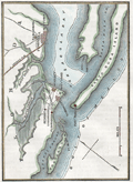 | Details | Anonymous | 1863 |
| Civil War era map Santa Rosa Island and Pensacola Florida |
|
Anonymous |
|
| 1863 |
| LOC:11 |
| $175.00 | Anonymous | Civil-War-era-map-Santa-Rosa-Island-and-Pensacola-Florida | Small hand-colored map of Santa Rosa Island and Pensacola Bay, Florida. Published before the end of the U. S. Civil War.
<br></br>
This fine map illustrates the fall of Pensacola to Rebel forces in "The History of the Civil War in America …" by John S. C. Abbott. Published in 1863 from Springfield, Massachusetts. Volume 1. Page 359.
<br></br>
<b>Includes the noted locations of these key features:</b>
<div class="indenttextblocksingle">
<ul style="list-style-type: circle;">
<li>Pensacola, Florida</li>
<li>Gulf of Mexico</li>
<li>Fort Barrancas </li>
<li>Fort McRae</li>
<li>Fort Pickens</li>
<li>Fort St. Miguel</li>
<li>Navy Cove</li>
<li>Warrington, Florida</li>
<li>Woolsey, Florida</li>
<li>Deer Point</li>
<li>Fair Point</li>
<li>Foster's Island</li>
<li>Pensacola Bay</li>
<li>Santa Rosa Island</li>
<li>Santa Rosa Sound</li>
<li>Bayou Chico</li>
<li>Bayou Grande</li>
<li>Grand Lagoon</li>
</ul>
</div>
Fort Pickens, located on the western tip of Santa Rosa Island in the Florida Panhandle, played a significant role in the United States' coastal defense system during the period from 1850 to 1870. The fort's strategic location allowed it to control the entrance to Pensacola Bay .
<br><br>
During the Civil War (1861-1865), Fort Pickens remained under Union control, despite Florida's secession from the United States in 1861. On January 12, 1861, just days before Florida officially seceded from the Union, a group of Florida state troops and local militia demanded the surrender of the Pensacola Navy Yard. The Union commander, Commodore James Armstrong, surrendered the yard to the Confederates without a fight. The Union forces, however, maintained control over Fort Pickens, located on Santa Rosa Island, which guarded the entrance to Pensacola Bay. Fort Pickens served as a base for Union operations along the Gulf Coast, and its presence helped to disrupt Confederate shipping and supply lines. |
| 5309 | 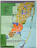 | Details | Dade County Planning Department | 1963 |
| Land Use Master Plan Miami Dade County Florida with maps |
|
Dade County Planning Department |
|
| 1963 |
| LOC:400 |
| $475.00 | Dade-County-Planning-Department | Land-Use-Master-Plan-Miami-Dade-County-Florida-with-maps | Proposed long-term master land use plan for Dade County, Florida published in October, 1963. The plan was prepared for the Board of County Commissioners of Dade County by the Metropolitan Dade County Planning Advisory Board and the Metropolitan Dade County Planning Department.
<br><br>
Very scarce on the market.
<br><br> 8 institutional holdings in WorldCat.
<br><br>
Folding document with 16 panels printed on both sides of a single sheet.
<br><br>
<b>Includes three large multicolored maps of Dade County, FL.</b>
<div class="indenttextblocksingle">
<ul style="list-style-type: circle;">
<li>Generalized existing land use for 1,080,000 population - 1963 estimate<br>
Metropolitan Dade County, Florida.</li>
<li>Proposed general land use master plan for 2,500,000 population - 1985 estimate<br>
Metropolitan Dade County, Florida. </li>
<li>Elements of the general plan.<br>
Population, Distribution, Major Traffic Generators and Transportation System</li>
</ul>
</div>
<b>Additional smaller inset maps include:</b>
<div class="indenttextblocksingle">
<ul style="list-style-type: circle;">
<li>Future urban form</li>
<li>Residential Development</li>
<li>Major Industry and Tourism</li>
<li>Major Parks and Recreation Areas</li>
<li>Major Commercial and Service Centers</li>
<li>Major Transportation Facilities</li>
</ul>
</div> |
| 5305 | 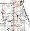 | Details | Searsce, F. W. | 1924 |
| Flagler Tribune Map Flagler County, Florida |
|
Searsce, F. W. |
|
| 1924 |
| LOC:87 |
| $400.00 | Searsce--F--W- | Flagler-Tribune-Map-Flagler-County--Florida | Map of Flagler County, Florida with overlay in red for drainage canals and drainage district boundaries. By F. W. Searsce. Includes the towns of Volusia, Harwood, Flagler Beach and parts of St. John's, Fulham, and Volusia counties. Shows about a 20 mile long stretch of the Old Kings Road north of Ormond. Land is shown surveyed using the Township and Range system.
<br></br>
TITLE: "The Flagler Tribune Map. Flagler County, Florida showing County Commissioners Districts and general information. Compiled in Office of F. W. Searsce. Bunnell, Florida."
<br></br>
Dated within at January, 1924. Scale about 1 inch - 2 miles.
<br></br>
In 1917 Flagler County was formed out of St. Johns and Volusia Counties. The Flagler Tribune was published weekly from 1917 to 1981 from Bunnell, Florida. On January 1, 1924 the paper was sold to Alexander Martin (Duke) McDaniel and Melvin Blanchard Fuller. Ownership remained unchanged until March 1939, when McDaniel sold his interest to Fuller. Sold in 1981, the paper is now known as the Flagler/Palm Coast News-Tribune. |
| 5296 |  | Details | Dunwody, William E. | 1922 |
| Earliest map of Charlotte, Glades, Hardee, Highlands counties Florida after DeSoto redivision |
|
Dunwody, William E. |
|
| 1922 |
| LOC:87 |
| $225.00 | Dunwody--William-E- | Earliest-map-of-Charlotte--Glades--Hardee--Highlands-counties-Florida-after-DeSoto-redivision | Map of DeSoto, Charlotte, Glades, Hardee, and Highlands counties in Florida ca. 1922. In 1921 the Florida legislature created the latter four counties out of what had previously been DeSoto County. Possibly the earliest map containing the names of those four new counties. Map is a Fotoprint printed by Foote & Davies Co, Atlanta.
<br></br>
Published by William Elliott Dunwody (1882-1956) a businessman in Arcadia, Florida, the seat of DeSoto County. Dunwody had interests in real estate, ranching, and citrus farming, and was Chairman of the local Selective Service Board from 1941 to 1954.
<br></br>
Interesting in that before this Fotoprint was produced a base plat map was edited in manuscript (by Dunwody ?) to show the new county boundaries and features: roads, railroads, towns, lakes; and type of terrain: swamp and muck, pine, or prairie. This item is a product of that enhancement made just after the new counties were created.
<br></br>
It is ironic that at center left, in one of the marked swampy areas, a manuscript notation is made: <b>"Red dot within green circle represents location your 10 acres."</b> Lucky guy! Key features include the Kissimmee River, Lake Istokpoga, Lake Okeechobee, Charlotte Harbor, and two airbases built in 1917 during early WWI: Carlstrom Field, and Dorr Field. |
| 5293 | 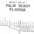 | Details | Brockway, George S. | 1940 |
| Promotional street map of Palm Beach Florida |
|
Brockway, George S. |
|
| 1940 |
| LOC:87 |
| $325.00 | Brockway--George-S- | Promotional-street-map-of-Palm-Beach-Florida | Promotional street map of Palm Beach, Florida from the Chamber of Commerce ca. 1940. A simplified map for visitors; limited in scope, this edition lacks detailed coverage of West Palm Beach and does not include either a key to street names or names of the inhabitants found in other similar maps by Brockway. Dated with reference to "Island no. 17" which is labeled "Pinner's Island" in Brockway's 1942 edition.
<br></br>
Verso is blank but with a blue ink stamp: "Courtesy of the Palm Beach Chamber of Commerce."
<br></br>
The map spans an area of southern Palm Beach from the Southern Boulevard Bridge (now Bingham Island Bridge) at north, past the Lake Worth Bridge, and terminating past the Lantana Bridge near the north corporate limits of Manalapan. By George S. Brockway, Engineer.
<br></br>
Features on the map include:
<div class="indenttextblocksingle">
<ul style="list-style-type: circle;">
<li>Lake Worth Municipal Golf Course</li>
<li>Phipps Ocean Park</li>
<li>Ibis Isle</br>
<li>Lake Worth Municipal Casino and Pool</li>
<li>South Ocean Club</li>
<li>WWPG radio broadcasting station</li>
<li>Island 17 and Island 18</li>
<li>Ambassador Hotel Villas</li>
<li>Hypoluxo Island</br>
</ul>
</div>
<br>
Two manuscript notations in pencil apparently for additions of Clifton and Corley Streets.
<br></br>
North oriented to right. Scale 1 inch = 1 mile. |
| 5278 | 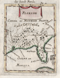 | Details | Mallet, Allain Manesson | 1683 |
| Decorative antique map of the Florida Territory |
|
Mallet, Allain Manesson |
|
| 1683 |
| LOC:11 |
| $250.00 | Mallet--Allain-Manesson | Decorative-antique-map-of-the-Florida-Territory | Unusual and somewhat primitive antique engraved map "Floride" of the eastern Gulf Coast including Florida ca. 1683. From Mallet's "Description de L'Univers". Printed from a copper-plate engraving onto chain-laid paper. Figure 18.
<br></br>
Mallet uses the names of native American Indians as place names. Florida is shown labeled as <b>Tegesta</b>. The Tegesta or Tequesta was a Native American tribe located mainly in southeastern Florida. Explorer, cartographer, and seafarer Bernard Romans used that label on his map of Florida as late as 1794.
<br></br>
Also shown is the area of the SW Florida coast inhabited by the Cossa or Calussa Indians and the area of the Apalachee Indians shown much too far to the north. |
| 5266 |  | Details | Anonymous | 1933 |
| Advertisement with map for Lake County, Florida |
|
Anonymous |
|
| 1933 |
| LOC: |
| $175.00 | Anonymous | Advertisement-with-map-for-Lake-County--Florida | Map of Lake County, Florida on an advertising brochure from the Lake County Chamber of Commerce. Fine graphics focused on the agricultural bounty available in a fertile and water-rich Florida. Shows numerous cities in central Florida including Altoona, Eustis, Howey, Clermont, Tavares, Sanford, and Orlando. Inset half-tone black and white illustrations of scenes typical to the area.
<br></br>
Brochure was issued by the Lake County Chamber of Commerce in Tavares, Florida to registrants at the Florida Exhibit during the Century of Progress Exhibition in Chicago (the 1933-34 Chicago World's Fair). |
| 5255 |  | Details | Anonymous | 1958 |
| Pictorial Map of Sanlando Springs attraction near Longwood, Florida |
|
Anonymous |
|
| 1958 |
| LOC: |
| $125.00 | Anonymous | Pictorial-Map-of-Sanlando-Springs-attraction-near-Longwood--Florida | Colorful pictorial map of the Sanlando Springs tourist attraction in Central Florida. Map is surrounded with drawings of family-oriented activities available at Sanlando: Jungle Cruise, outdoor cooking, dancing on the patio. Based on the postal rate of 3 cents this item probably dates to the late 1950's. Folding map, verso with space for a stamp and address as well as a pre-written letter in script touting the many things to do at Sanlando.
<br></br>
Sanlando Springs, along with nearby Rock Springs, Wekiwa Springs and Palm Springs, form the headwaters of the Wekiva River.
<br></br>
The spring, originally Hoosier Springs, was used for recreation as far back as the 1880's. The location was renamed as Sanlando by Altamonte Mayor J.F. Haithcox who developed the location as an amusement park in the 1920's. (Source: https://studiohourglass.blogspot.com/2013/06/giving-new-life-to-sanlando-springs.html). |
| 5244 | 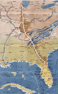 | Details | Nashville Chattanooga and St. Louis Railway | 1922 |
| Early twenties map of the Dixie Route from Chicago to Florida |
|
Nashville Chattanooga and St. Louis Railway |
|
| 1922 |
| LOC:200 |
| $375.00 | Nashville-Chattanooga-and-St--Louis-Railway | Early-twenties-map-of-the-Dixie-Route-from-Chicago-to-Florida | Fine and attractive early map (1922) of the Dixie Route in the center of a twenty-page brochure mostly devoted to Florida sights and cities. Inset map of Cuba. Published by the Poole Brothers on October 2, 1922.
<br></br>
The Dixie Route was a train service that in 1939 operated three passenger trains across several affiliated railroads and their stops to provide passenger service from the Midwest (St. Louis and Chicago) to Florida. |
| 5184 |  | Details | U.S. Coast and Geodetic Survey | 1929 |
| Florida Inside Route St. Augustine to Titusville |
|
U.S. Coast and Geodetic Survey |
|
| 1929 |
| LOC:61 |
| $180.00 | U-S--Coast-and-Geodetic-Survey | Florida-Inside-Route-St--Augustine-to-Titusville | Chart of a portion of what is today known generally as the Intracoastal Waterway: "Florida Inside Route St. Augustine to Titusville." South of the Matanzas Inlet, a portion of the inside route opposite Flagler Beach is labelled "Florida East Coast Canal." In the 1920's portions of the Inside Route were maintained by private entities who paid for canal maintenance by charging a toll for use of the waterway. As many as six toll stations existed in those days from Jacksonville to Hallandale, Florida.
<br></br>
First published by the U. S. Coast and Geodetic Survey, Washington D. C. in September 1928. Chart # 3258. Stamped October 17, 1929. |
| 5180 |  | Details | Fiske, John | 1902 |
| Sketch of the earliest map of Florida coast by Fiske after Cantino |
|
Fiske, John |
|
| 1902 |
| LOC:11 |
| $135.00 | Fiske--John | Sketch-of-the-earliest-map-of-Florida-coast-by-Fiske-after-Cantino | Sketch of the Florida coast, a sketch of the earliest image of Florida known from an anonymous Portuguese manuscript portolan map of the world: The Cantino Planisphere. Martin Waldseemuller's 1507 map is derived from the Cantino Planisphere.
<br></br>
In 1501 Alberto Cantino commissioned a Portuguese official to make a map with all the latest discoveries known to the Portuguese. That large map incorporated discoveries made by several explorers in the first decade of the 16th century and revealed unpublished details of Portuguese trade routes.
<br></br>
This bookplate sketch of a portion of Cantino's map is from "The Discovery of America" by John Fiske, 1892. |
| 5145 | 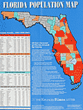 | Details | Kiplinger Washington Editors, Inc. | 1991 |
| Florida Population map for 1991 |
|
Kiplinger Washington Editors, Inc. |
|
| 1991 |
| LOC:87 |
| $100.00 | Kiplinger-Washington-Editors--Inc- | Florida-Population-map-for-1991 | Colorful, poster sized, Florida Population Map for 1991 produced for The Kiplinger Florida Letter. The map shows county forecasts for population growth in 1996 and 2001 in the State of Florida. Kiplinger forecast that the population of Florida would grow from 13.2 million to 16 million in 2001, a 21% increase. Kiplinger is a Washington, D.C.-based publisher of business forecasts and personal finance advice.
<br></br>
Includes four population tables and text. Price when issued was $5.00.
<br></br>
Clearly marked as "Not to be used for navigation." |
| 5144 | 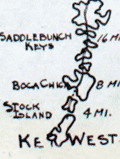 | Details | Zorsky, Joseph | 1940 |
| Map from Cactus Terrace Cottages First Motel in Key West |
|
Zorsky, Joseph |
|
| 1940 |
| LOC:11 |
| $95.00 | Zorsky--Joseph | Map-from-Cactus-Terrace-Cottages-First-Motel-in-Key-West | Map of the Florida Keys ca. 1940 from Cactus Terrace Cottages and Motel which was the first motel built in Key West, in the 1930's. The Cactus Terrace was located on Highway 1 across from the Catholic Church. With a larger scale inset map showing roads and location of the motel on the island of Key West.
<br></br>
In the 1930's Joseph Zorsky (1894 - 1971) founded the Cactus Terrace Motor Court on land that formerly contained Key West Mayor Walter Maloney's fruit orchard, as well as the historic Maloney House, built in 1854.. In 1971 Zorsky was killed during a robbery attempt and eventually the property was renamed Key Lime Village (now Key Lime Inn).
<br></br>
Verso with faint half-tone images of the hotel and properties which include an early bird's-eye photograph of the Cactus Terrace Motel and of "the largest collection of cactus east of the Mississippi." |
| 5137 | 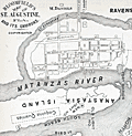 | Details | Bloomfield, Max | 1884 |
| Bloomfield's Map of St. Augustine Fla. and its Environs |
|
Bloomfield, Max |
|
| 1884 |
| LOC:11 |
| $250.00 | Bloomfield--Max | Bloomfield-s-Map-of-St--Augustine-Fla--and-its-Environs | Antique map of St. Augustine, Florida from "Bloomfield's Illustrated Historical Guide Embracing an Account of the Antiquities of St. Augustine, Florida." Fine detail shows the coquina quarries, Fort Marion, the Matanzas River, Anastasia Island and both the new lighthouse and the location of the old lighthouse. A shell road is shown entering the city past the city gates.
<br></br>
Published in 1884 by Max Bloomfield, Bookseller, News dealer and Stationer of St. Augustine, Florida. Copyrighted. At right a list of references in the City of St. Augustine including the old Spanish graveyard, the Huguenot Cemetery, the old slave market, and a monument to the Confederate dead.
<br></br>
North oriented to right. |
| 5132 |  | Details | J. Walker Pope and Son | 1919 |
| Official Road Map of Polk County Florida, 1919 |
|
J. Walker Pope and Son |
|
| 1919 |
| LOC:87 |
| $265.00 | J--Walker-Pope-and-Son | Official-Road-Map-of-Polk-County-Florida--1919 | Scarce map of Polk County, Florida highways: "Official Road Map of Polk County Florida, 1919 showing the famous 300 mile system of asphalt paved highways. Approved by J. Walker Pope. President Polk County Good Roads Association, Winter Haven." District roads are shown in dark red. According to advertising copy on the map:
<div class="indenttextblocksingle">
Polk County ships over a million boxes of citrus fruits and two thousand car loads of winter vegetable annually -- and furnishes over 40 per cent of the world's output of phosphate."
</div>
<br></br>
The map is printed on the verso of a single-sheet folding advertisement for J. Walker Pope and Son of Winter Haven, Florida. Recto with six half-tone photographs including local orange groves, Mountain Lake Golf Course, Lake Wales, and the offices of J. Walker Pope and Richard D. Pope of Winter Haven, Florida.
<br></br>
J.W. Polk was President of the Polk County Good Roads Association, President of the Winter Haven Motor Club, and Vice-President of the United States Highway Association. |
| 5129 | 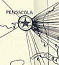 | Details | U.S. Army Engineers | 1929 |
| Port of Pensacola, Florida scarce photomosaic and two maps |
|
U.S. Army Engineers |
|
| 1929 |
| LOC:0 |
| $300.00 | U-S--Army-Engineers | Port-of-Pensacola--Florida-scarce-photomosaic-and-two-maps | Small booklet of 66 pages that includes 3 cartographic artifacts related to Pensacola, Florida.
<div class="indenttextblocksingle">
<ul style="list-style-type: circle;">
<li>Mosaic Composed of Aerial Photographs Pensacola Florida. Made by Air Service, U.S. Army 4th Photo Section. Dec. 22, 1922.</li>
<li>Origin of Imports and Destination of Exports Pensacola, Fla. 1928. Quantities expressed in cargo tons of 2240 lbs. and shown thus. 1929.</li>
<li>Port Facilities at Pensacola, Fla. 1929.</li>
</ul>
</div>
Along with many data tables and additional photographs the contents of the entire booklet include:
<div class="indenttextblocksingle">
<ul style="list-style-type: circle;">
<li>Port and Harbor Conditions</li>
<li>Port Customs and Regulations</li>
<li>Port Services and Charges</li>
<li>Fuel and Supplies</li>
<li>Port and Harbor Facilities</li>
<li>Communications</li>
<li>The freight rate situation</li>
<li>Commerce of the port</li>
<li>The territory tributary to the port</li>
<li>General</li>
</ul>
</div>
War Department Corps of Engineers and United States Shipping Board Port Series No. 3 Part 2 THE PORT OF PENSACOLA, FLORIDA.
Printed by the U.S. Government Printing Office, Washington, D.C. 1929. Price when issued 30 cents. |
| 5124 | 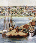 | Details | Straub, W.L. | 1917 |
| Antique airplane views of St. Petersburg Florida |
|
Straub, W.L. |
|
| 1917 |
| LOC:11 |
| $400.00 | Straub--W-L- | Antique-airplane-views-of-St--Petersburg-Florida | Brochure with maps and scarce airplane views of St. Petersburg, Florida including a fine oblique elevated view of the harbor: "St. Petersburg, the Place 'of Proved Desire and Known Delight' " by artist W.L. Straub (15" x 6"). Found at the center of a six-panel folding brochure- "St. Petersburg Florida, The Sunshine City Issued by the St. Petersburg Board of Trade."
<br></br>
Along with numerous smaller illustrations and photographs the brochure includes additionally two fine views and two maps:
<div class="indenttextblocksingle">
<ul style="list-style-type: circle;">
<li>View of the "mole", the "spa", the municipal pier and bathing beaches</li>
<li>Panoramic view of St. Petersburg, Fla. from the Plaza Theater (by Van Deventer & Sons 1913.</li>
<li>Map showing location of St. Petersburg Florida with Railroad and Steamship Connections.</li>
<li>Map of Pinellas County, Florida showing location of St. Petersburg "The Sunshine City".</li>
Brochure folds to 9" x 4". |
| 5118 | 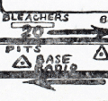 | Details | Coker, Broward | 1958 |
| Sebring Endurance Race Official Safety and Communications Card |
|
Coker, Broward |
|
| 1958 |
| LOC:11 |
| $125.00 | Coker--Broward | Sebring-Endurance-Race-Official-Safety-and-Communications-Card | Official safety and communications card for the 12-Hour Florida International Grand Prix of Endurance. This 12-hour endurance race for the Amoco Trophy was held at the Sebring Air Terminal on March 22, 1958, the seventh year the race was run. A Ferrari 250 TR 58, driven by Phil Hill and Peter Collins won the race.
<br></br>
Map shows the course layout among the runways and taxiways of the air terminal. The card documents radio communications procedures and protocols for ambulances and fire trucks during the race.
<br></br>
Sebring International Raceway, America’s oldest road racing track, evolved from Hendricks Field, a World War II airbase used to train B-17 combat crews. Sebring is well known for celebrity participation. Steve McQueen, James Brolin, Paul Newman, Gene Hackman and even journalist Walter Cronkite have competed in the race. (Source: https://www.sebringraceway.com/track-info/about-sir) |
| 5122 | 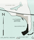 | Details | Ramrod Investments, Inc. | 1965 |
| Scarce map and sales brochure for Cutthroat Harbor Estates Cudjoe Key Florida |
|
Ramrod Investments, Inc. |
|
| 1965 |
| LOC:87 |
| $120.00 | Ramrod-Investments--Inc- | Scarce-map-and-sales-brochure-for-Cutthroat-Harbor-Estates-Cudjoe-Key-Florida | Plat of the first addition to Cutthroat Harbor Estates on the ocean side of Cudjoe Key, Florida. Plat is in a folding ten-panel sales brochure offering lots for sale in Cutthroat Harbor from $1,990 bordering Sacarma Bay, eighteen miles from Key West on U.S. Highway 1. Dated within to 1965, the brochure includes a small-scale map of the development in relationship to the southern portion of Cudjoe Key, and an aerial photograph of the same area.
<br></br>
The brochure includes a table of annual average weather conditions, photographs of construction work at the area, local fishing and boating activities, and the Key West International Airport. |
| 5103 |  | Details | Burgert Brothers | 1920 |
| Lakemont Florida Early Bird's-eye View |
|
Burgert Brothers |
|
| 1920 |
| LOC:11 |
| $125.00 | Burgert-Brothers | Lakemont-Florida-Early-Bird-s-eye-View | Scarce drawn bird's-eye view of Lakemont, Florida ca. 1920 as it was being platted and developed for sale. Below the scene of lots, lakes, and orange groves, a brief description explains the view (shown looking south):
<div class="indenttextblocksingle">
"Lakemont, located between Avon Park and Sebring, Fla., at the crossing of scenic highway and S.A.L.R.R. [Seaboard Air Line Railway]"
</div></br>
Description on the verso reads:
<div class="indenttextblocksingle">
"LAKEMONT, FLA. A new townsite now being developed and destined to become a city within the next few years, located in the Ridge Section at the crossing of scenic highway and new S.A.L. Railroad. Four miles north of Sebring and five miles south of Avon Park, Florida."
</div></br>
Major topographic features include the city of Sebring with Dinner Lake, Lake Jackson, Basket Lake, Bonnet Lake, and Little Red Water Lake.
<br></br>
Folding postal card in two panels. White border (1915-1930). No. 103139. Fl. Fla. Postally unused. Dated with reference to the founding of Sebring, Florida in 1912. Published by Burgert Brothers of Tampa, Florida. |
| 5108 |  | Details | Lake Worth Herald Press | 1928 |
| 1927 Florida State Road Map |
|
Lake Worth Herald Press |
|
| 1928 |
| LOC:87 |
| $125.00 | Lake-Worth-Herald-Press | 1927-Florida-State-Road-Map | Road map for the entire state of Florida in a ten-panel folding brochure published during the 1920's Florida land boom, prior to the Great Depression. The brochure is titled: "Greeting Nobles, Oases of Lake Worth welcomes you. This road guide will assist you in your tour of Florida while attending the Shrine Convention at Miami, May 1, 2, 3, 1928."
<br></br>
Cover with logo for the Shriner organization. Verso captioned "Lake Worth Greets You" and filled with text descriptions and half-tone photographs of Lake Worth's attractions including the Municipal Recreational Center, the Gulf Stream Hotel, and its fine schools.
<br></br>
Published by the Lake Worth Herald Press. |
| 5109 |  | Details | Winter Park Board of Realtors | 1951 |
| Mid-century map of Winter Park Florida |
|
Winter Park Board of Realtors |
|
| 1951 |
| LOC:87 |
| $115.00 | Winter-Park-Board-of-Realtors | Mid-century-map-of-Winter-Park-Florida | Map of the city of Winter Park, Florida and vicinity published by the Winter Park Board of Realtors (1952) in a 12-panel folding format. Lakes shown boldly in green. Key at bottom left with road reference locations in Orlando, Eatonville, Maitland, and Winter Park. One section of road highlighted in red. Small manuscript notation in pencil.
<br></br>
Verso titled "Maps and facts about Winter Park Florida <b>City of Homes</b>." Full of text and photographs related to Winter Park, particularly to Rollins College and to the history behind Winter Park's appellation as the "City of Homes." With logo for the National Association of Real Estate Boards at bottom right. Border with alpha-numeric location index indicators.
<br></br>
Shows more than a dozen lakes of all sizes including Lake Fairview, Lake Killarney, Lake Maitland, Lake Osceola, Lake Corrine, and Lake Rowena.
<br></br>
Copyright 1952 by James T. Ellis. Interesting compass rose style unknown logo by Ellis' name. |
| 5114 | 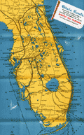 | Details | Poole Brothers, Inc. | 1935 |
| Map Dixie Route rail service to Florida |
|
Poole Brothers, Inc. |
|
| 1935 |
| LOC:11 |
| $200.00 | Poole-Brothers--Inc- | Map-Dixie-Route-rail-service-to-Florida | Map (8" x 15") within a twenty-two page folding brochure for <b>The Dixie Route</b>, a train service that in 1939 operated three passenger trains across several affiliated railroads and their stops to provide passenger service from the Midwest (St. Louis and Chicago) to Florida. The railway companies contributing to the brochure included:
<div class="indenttextblocksingle">
<ul style="list-style-type: circle;">
<li>Chicago and Eastern Illinois Railway</li>
<li>Louisville and Nashville Railroad</li>
<li>Nashville, Chattanooga, and St. Louis R.Y</li>
</ul></div>
Daily Dixie Route trains to Florida were The Dixieland (with overnight service to Florida) , The Dixie Flyer, and The Dixie Limited.
<br></br>
Copyright 1935 by publishers Poole Brothers, Inc. Published October 1939 (dated within).
<div class="indenttextblocksingle">
Poole Brothers was a publishing company founded in 1870 by George Amos and William H. Poole. The company was the largest printing house in the country that catered to transportation companies. According to The Inland Printer, "practically every railroad in the country used Poole Brothers materials." [1] </div>
</br>
[1] Source: https://en.wikipedia.org/wiki/Poole_Brothers |
| 5099 |  | Details | U.S. Coast and Geodetic Survey | 1951 |
| Tampa Bay Tidal Current Chart Book |
|
U.S. Coast and Geodetic Survey |
|
| 1951 |
| LOC:0 |
| $200.00 | U-S--Coast-and-Geodetic-Survey | Tampa-Bay-Tidal-Current-Chart-Book | Scarce 1951 tidal chart book on card stock with 12 (front and back) charts of Tampa Bay, Florida showing the direction and velocity of tidal flow across Tampa bay for each hour of its semi-daily tidal cycle.
<br></br>
Price when issued 35 cents; when sold 50 cents. U.S. Government Printing Office. Serial no.743. |
| 5095 |  | Details | Gulf Coast Impressions | 1996 |
| 50th anniversary poster map Pensacola Blue Angels |
|
Gulf Coast Impressions |
|
| 1996 |
| LOC:87 |
| $145.00 | Gulf-Coast-Impressions | 50th-anniversary-poster-map-Pensacola-Blue-Angels | Pictorial poster map of Pensacola, Florida printed for the 50th Anniversary of The Navy Blue Angels Precision Flying Squadron. With advertising for local businesses. Glossy paper.
<br></br>
The Blue Angels were formed in 1946 under the leadership of Admiral Chester Nimitz to increase public interest in naval aviation. Since 1955 the Blue Angels have made Forrest Sherman Field, Naval Air Station Pensacola, Florida their home base during the air show season. |
| 5096 |  | Details | Louisville and Nashville Railroad | 1971 |
| Lot of 2 scarce Louisville and Nashville Railroad Florida Track Profile Charts |
|
Louisville and Nashville Railroad |
|
| 1971 |
| LOC:0 |
| $600.00 | Louisville-and-Nashville-Railroad | Lot-of-2-scarce-Louisville-and-Nashville-Railroad-Florida-Track-Profile-Charts | Lot of 2 scarce original Louisville and Nashville Railroad Florida track profile charts for their Pensacola & Atlantic Sub-division and Yellow River Branch lines. First printed in 1930 and revised and redrawn in Mobile, Alabama by R.W.P. in October 1971.
<br></br>
Condensed track profile charts are engineering documents giving mile-by-mile documentation of every aspect of a railroad’s right-of-way and trackwork: track layout, grades, curvature, bridgework, etc. Track profile charts may contain:
<div class="indenttextblocksingle">
<ul style="list-style-type: circle;">
<li>Milepost numbers</li>
<li>Direction of the line via compass heading for sub-segments of the line</li>
<li>Slope of the grade for each sub-segment</li>
<li>Details about culverts, bridges, arches, and boxes</li>
<li>Town names</li>
<li>Locations of railway infrastructure (freight depots, passenger stations, and signals) </li>
</ul>
</div>
First printed in 1930, these two volumes were updated in 1971 by "R.W.P."
<div class="indenttextblocksingle">
<ul style="list-style-type: circle;">
<li>The smaller of the two books (Vol. 1) contains track map profiles for 43 miles of track of the Pensacola Division of the L & N R.R. extending south from Flomaton, Alabama to Pensacola, Florida. Includes two pages of railway symbol conventions and common abbreviations; a list of stations on the route; and layouts for the Pensacola, Goulding, and Flomaton rail yards.</li>
<li>The larger volume (Vol. 2) includes track profiles for the Yellow River Branch of the L & N R.R. from Florala to Crestview, Florida and for the Pensacola and Atlantic Branch of the L & N R.R. extending from Pensacola (Red Bluff), Florida eastward to River Junction, Florida. Includes two pages of railway symbol conventions and common abbreviations; a list of stations on the route; and layouts for the Muskogee Wharf, Pensacola, Pace, and River Junction rail yards and facilities.</li>
</ul>
</div> |
| 5089 | 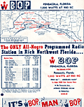 | Details | WBOP Radio | 1963 |
| WBOP All-Negro AM Radio Pensacola Florida Coverage Map |
|
WBOP Radio |
|
| 1963 |
| LOC:11 |
| $225.00 | WBOP-Radio | WBOP-All-Negro-AM-Radio-Pensacola-Florida-Coverage-Map | Coverage contour map for AM radio station WBOP in Pensacola, Florida from September 1963. Map compiled by Bill Lee of WLAK Electronics Service, Lakeland, Florida. With consumer marketing data for the black population in the WBOP market area. African-American interest. Station coverage extends as far north as South Flomaton and as far east as Foley, Florida. |
| 5087 |  | Details | Tampa Board of Trade | 1923 |
| Tampa the Strong Box in the Treasure House of Florida |
|
Tampa Board of Trade |
|
| 1923 |
| LOC:11 |
| $250.00 | Tampa-Board-of-Trade | Tampa-the-Strong-Box-in-the-Treasure-House-of-Florida | Pre-depression advertising map promoting Tampa and Hillsborough County as: "The Strong Box in the Treasure House of Florida". Beneath the map an explanation describes the benefits to be found in Hillsborough County:
<div class="indenttextblock">
"Containing lands, rich and of infinite variety, adapted for fruit raising, agriculture in all its phases, trucking, poultry farming, stock raising, and all those novelty lines for which Florida is famous. The marketplace of practically all of South and West Coast Peninsular Florida, with over fifty miles of salt water shoreline. Look us over."
</div>
Unusual and scarce. 1923.
<br></br>
Map image with strong graphics is inside the front cover of 44-page brochure ( 9" x 6") about Tampa, Florida. Brochure wraps covered with images of local leisure activities for Tampa (front) and Hillsboro County (rear). On both covers images of bi-planes cruising aloft attest to the importance of Tampa, Florida as an early aviation center. |
| 5088 |  | Details | Rockford Map Publishers | 1975 |
| Atlas and Plat Book Suwannee County Florida 1975 |
|
Rockford Map Publishers |
|
| 1975 |
| LOC:2001 |
| $200.00 | Rockford-Map-Publishers | Atlas-and-Plat-Book-Suwannee-County-Florida-1975 | Atlas and Plat Book Suwannee County Florida 1975, published by Rockford Map Publishers, Inc. Rockford, Illinois. Sponsored by Daniel Crapps, Realtor, Live Oak, Florida.
<br></br>
Contents contain an index map for Suwannee County; an alphabetized business directory; important facts about land descriptions; detailed maps for each of 23 townships in the index map; a map of the capital city of Suwannee County- Live Oak; a map of the city of Branford; and a reduced general highway map of Suwannee County, Florida. |
| 5076 |  | Details | Smiley, Russ | 1987 |
| Russ Smiley's Fishing-Boating Map Cape Sable to Crystal River |
|
Smiley, Russ |
|
| 1987 |
| LOC: |
| $175.00 | Smiley--Russ | Russ-Smiley-s-Fishing-Boating-Map-Cape-Sable-to-Crystal-River | Late 1980's chart of the Everglades, South Florida, and the Florida Keys surrounded by Smiley's illustrations of colorful fishes. Chart is overprinted with dots representing hot fishing spots and with the names of the fishes that might be caught in an area.
<br></br>
Created and published by Miami, Florida artist Russ Smiley. Last copyright is from 1979 by Russ Smiley. Purchased as new old stock. Published by Windward Publishing, Miami.
<br></br>
Verso with illustrations of south Florida fishes, fishing techniques, and baits. |
| 5066 | 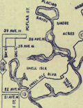 | Details | Anonymous | 1951 |
| Route Map of the Municipal Transit System St. Petersburg, Florida |
|
Anonymous |
|
| 1951 |
| LOC:87 |
| $150.00 | Anonymous | Route-Map-of-the-Municipal-Transit-System-St--Petersburg--Florida | Scarce route map of the Municipal Transit System in St. Petersburg, Florida (not to scale). On thinnish yellow paper a fourteen-panel folding sheet folds to 3" x 8". Includes an inset plan for downtown St. Petersburg revised October, 1951. The Yellow Issue published Dec 3, 1951. |
| 5057 |  | Details | Florida East Coast Railway | 1933 |
| Map of Florida East Coast Railway the St. Augustine Route |
|
Florida East Coast Railway |
|
| 1933 |
| LOC:200 |
| $250.00 | Florida-East-Coast-Railway | Map-of-Florida-East-Coast-Railway-the-St--Augustine-Route | Colorful folding map of Henry Flagler's Florida East Coast Railway, the St. Augustine Route. Includes the Key West extension and the route from Key West to Havana, Cuba of the Peninsular and Occidental Steamship Company.
<br></br>
Interesting and seemingly out-of-place notations for two fishing camps on the Keys: Pirates Cove fishing camp and Long Key fishing camp. Printed by the Record Company, St. Augustine, Florida. Map is in the center of a folding brochure of 15 pages. |
| 5058 |  | Details | Anonymous | 1930 |
| Lane Park Cottages Lake Harris Tavares, Florida |
|
Anonymous |
|
| 1930 |
| LOC:11 |
| $50.00 | Anonymous | Lane-Park-Cottages-Lake-Harris-Tavares--Florida | Small map of Lane Park Cottages on Lake Harris, three miles southwest of downtown Tavares, Florida ca. 1930's. Lane Park is named for Captain A.J. Lane who as early as 1883 had plans for developing a peninsula that extended into Lake Harris. Map is on a postcard with two photographs of the cottages.
<br></br>
These cottages were likely the same as those attributed to Robert Kleiser:
<div class="indenttextblock">
"Kleiser's Fish Camp was established in 1918 on an island located in the middle of Lake Harris. Robert Forest Kleiser acquired the island and built six cottages, several boat sheds, and a pier. Several years later, Kleiser disassembled the cottages and moved the camp to Lane Park." (Grenier, Bob. Images of America: Tavares. Arcadia Publishing. 2011)
</div>
</br>
Printed by the County Seat Printers, Tavares, Florida. |
| 5061 |  | Details | U.S. Army Engineers | 1960 |
| Two maps of recreation facilities on the Okeechobee Waterway. |
|
U.S. Army Engineers |
|
| 1960 |
| LOC:87 |
| $150.00 | U-S--Army-Engineers | Two-maps-of-recreation-facilities-on-the-Okeechobee-Waterway- | Two charts of recreation facilities on the Okeechobee Waterway stretching across the state from East Florida to West Florida. Recto with a map of recreation facilities including locks and dams along the Caloosahatchee River from Pine Island Sound to Moore Haven on Lake Okeechobee. Includes the Ortona Lock and Dam and the Franklin Lock and Dam.
<br></br>
Verso with a map of Lake Okeechobee and the Okeechobee waterway outlet to the Atlantic Ocean at Stuart, Florida. Published by the U.S. Army Corps of Engineers, Jacksonville District. |
| 5062 | 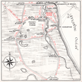 | Details | St. Augustine Green Cove Springs Bridge Company | 1928 |
| Map of Shands Bridge over the St. Johns River |
|
St. Augustine Green Cove Springs Bridge Company |
|
| 1928 |
| LOC:11 |
| $180.00 | St--Augustine-Green-Cove-Springs-Bridge-Company | Map-of-Shands-Bridge-over-the-St--Johns-River | Map of the first Shand's Bridge over the St. Johns River in Florida from 1928. Map in folding brochure 18" x 6" with information on the Shand's Toll Bridge in the year of its opening. The bridge was conceived, financed and built privately by the St. Augustine Green-Cove Springs Bridge Company.
<br></br>
Title: "Shands Bridge over the St. Johns River connecting scenic highways St. Augustine and Green Cove Springs: Florida's longest single span bridge Open April 10, 1928."
<br></br>
In 1928 the bridge was a toll bridge of wooden construction, except for the draw span. The current bridge, located just south of the old bridge, opened in 1963. |
| 5056 |  | Details | Anonymous | 1960 |
| Map Seven Seas Sightseeing Miami and Miami Beach Cruise |
|
Anonymous |
|
| 1960 |
| LOC:11 |
| $85.00 | Anonymous | Map-Seven-Seas-Sightseeing-Miami-and-Miami-Beach-Cruise | Brochure for a 2.5 hour lectured cruise of North Biscayne Bay, Miami Beach, Florida aboard the double-decked motorboat Seven Seas. With a map of the cruise route (in red) around North Biscayne Bay.
<br></br>
Unlike other cruises on south Biscayne Bay (e.g. Uncle Sam cruise) the Seven Seas cruise was operated in<b> North Biscayne Bay</b>, departing from Pier 8 at the Miami City Yacht Basin twice daily. The cruise passed the Venetian Causeway, passed the Charles Deering estate, and sailed past the 79th street causeway, retiring past Mt. Sinai Hospital and making a circle in Sunset Lake before docking 2 1/2 hours later. Other points of interest included the Goodyear Blimp Base, Flagler Memorial Monument, Little River, and Indian Creek Village.
<br></br>
Printed on both sides and folds to 4" x 9". |
| 5054 |  | Details | Green, John B. | 1951 |
| Map brochure for Brightwaters Snell Isle Harbour St. Petersburg Florida |
|
Green, John B. |
|
| 1951 |
| LOC:87 |
| $400.00 | Green--John-B- | Map-brochure-for-Brightwaters-Snell-Isle-Harbour-St--Petersburg-Florida | Scarce original plat map of <b>Snell Isle Harbor</b> in St. Petersburg, Florida ca. 1951, by John B. Green, a local realtor. Includes red manuscript notes about lots previously sold. With an inset photograph of the area surrounding Brightwaters Snell Isle. Shows the outline of property for Clark's Sunset Golf Course and a block reserved as a business center. North is oriented to left bottom. Plat includes Snell Isle Boulevard, Cordova Boulevard, Toledo Way, Miramar Blvd., and Brightwaters Boulevard. Verso with information and a fine bird's eye view of the planned development.
<br></br>
Now one of St. Petersburg’s most upscale and desirable neighborhoods, Snell Isle was once nothing more than a low-lying mangrove swamp. When C. Perry Snell, a Kentucky pharmacist, came to visit the area in 1899, he envisioned a residential waterfront enclave and invested in the property of what is now Coffee Pot Bayou and Snell Island. In 1911, he began developing Snell Island.
<br></br>
In 1926, Snell opened the Coffee Pot Bayou Golf Club, now the 18-hole Vinoy Renaissance Resort Golf Club on Snell Isle. A few years later in 1928, he gifted land to the St. Petersburg Woman’s Club which still stands today on Coffee Pot Bayou and is on the U.S. Register of National Historic Places.
<br></br>
Snell Isle is completely residential, with several apartment communities, two schools, and two churches. Many original homes from the 1920s still exist today, with charming European and Spanish architecture. More than 80 percent of homes on Snell Isle enjoy waterfront views, some of the Bay and others on interconnected waterways. |
| 5055 |  | Details | Anonymous | 1962 |
| Lot of six (6) scarce Fin Fishing Charts Lemon Bay to Tarpon Springs Florida |
|
Anonymous |
|
| 1962 |
| LOC:40 |
| $180.00 | Anonymous | Lot-of-six-(6)-scarce-Fin-Fishing-Charts-Lemon-Bay-to-Tarpon-Springs-Florida | Lot of six scarce "Fin Fishing Charts" for Florida coastal areas in the vicinity of Tampa Bay, Florida. Charts folded as issued.
<br></br>
All charts fit inside a point-of-sale envelope/folder printed with an index map of southern Florida showing all available Fin Fishing charts and highlighting these specific charts from Lemon Bay to Tarpon Springs: W7, W8, W9, W10, W11, W12.
<br></br>
Hot fishing spots are highlighted with red dots and tide table adjustments are included for several locations. Several marinas and other business establishments are noted in red on the charts, probably locations that sold these charts or that paid for the advertisement. Ink stamp on the folder carries a date of March 6, 1962. Creator of the charts is unattributed and very few, if any, of these charts are available on the market. |
| 5050 | 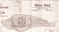 | Details | Lovett Company | 1925 |
| Rare, early map of Nela Isle Subdivision Orlando Florida. |
|
Lovett Company |
|
| 1925 |
| LOC:11 |
| $350.00 | Lovett-Company | Rare--early-map-of-Nela-Isle-Subdivision-Orlando-Florida- | Early, pre-construction map of the Nela Isle Subdivision on Lake Conway at Orlando, Florida in Orange County. Rare. Map on verso of a four-panel folding brochure. Dated within at August, 1925.
<br></br>
By The Lovett Company 118 S. Orange Avenue, Orlando, Florida. Map drawn by M. Klein, Cleveland, Ohio. With an inset large-scale context map showing Nela Isle in the larger Orlando, Lake Conway, Pine Castle area.
<br></br>
Verso with title and a fine two-panel Artist's Conception of the New Bridge to Nela Isle. According to the brochure:
<div class="indenttextblocksingle">
"Plans are being developed by the Florida Associated Engineers--- The Bridge will soon be a Reality. Watch Nela Grow." </div>
MS signature of Geo[rge] W. Ireland 1897 (likely the phone number). Scale 1" = 200'. |
| 5052 | 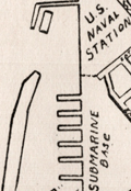 | Details | Rice, George T. | 1931 |
| Map of Key West Florida |
|
Rice, George T. |
|
| 1931 |
| LOC:11 |
| $250.00 | Rice--George-T- | Map-of-Key-West-Florida | Scarce map of Key West Florida in booklet "Fifth Annual Tourists Sight Seeing Guide of Key West Florida 1933 Courtesy of Key West Business People". Locations identified numerically on the map appear not to correspond to numbered locations in the booklet. It is informative to compare this map with a very similar sightseeing map (1945-1948) in the Touchton Map Library. Numerous changes to Key West related to WWII are apparent, especially the construction of Meacham Field.
<br></br>
Booklet 3.5" x 7" with advertisements for local Key West businesses including: The Artman Press, The Key West Citizen, Gardner's Pharmacy, Columbia Laundry, The Key West Colonial Hotel and more. With a list of facts about Key West and a description of a tour of local sights including the "turtle crawls":
<div class="indenttextblocksingle">
"3. Visit the turtle crawls where turtles weighing over two hundred pounds may be seen swimming by dozens in pens while waiting to be slaughtered. Turtles have been caught near Key West weighing over one thousand pounds. This is a sight to remember. Located: Dock at North end of Margaret street."
</div></br>
The map was compiled under the direction of George T. Rice, Captain 13th C.A. (Coast Artillery). Drawn by A.D. Shirk, Staff Sergeant, 13th C.A. July 10, 1931. |
| 5053 | 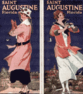 | Details | Anonymous | 1918 |
| Two manuscript maps of St. Augustine, Florida and of the area. |
|
Anonymous |
|
| 1918 |
| LOC:11 |
| $400.00 | Anonymous | Two-manuscript-maps-of-St--Augustine--Florida-and-of-the-area- | Two manuscript maps on a single sheet inserted into a tourism brochure of St. Augustine, Florida after printing. Unusual. Maps show St. Augustine at street-level detail and on verso a smaller-scale map of the area surrounding St. Augustine. Type-written text on one map sheet indicates re-use of a telephone service remittance document for creation of the map. The small scale map of the area around St. Augustine appears only to consider railway lines (F.E.C., A.C.C.) of importance as railways are highlighted in color and stops along each route are identified.
<br></br>
Booklet (folds to 4" x 9") presented with the compliments of the St. Augustine Hotel Association. Fine cover graphics of period clothing. Booklet art work, engraving and printing by the Record Company, St. Augustine. Dated between 1916 and 1919 based on information provided about the Flagler Hospital, under construction at printing, after a fire in 1916 destroyed much of the original structure. |
| 5049 | 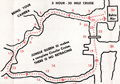 | Details | Jungle Queen Tours | 1960 |
| Route Map Jungle Queen Sightseeing Cruises Fort Lauderdale |
|
Jungle Queen Tours |
|
| 1960 |
| LOC:11 |
| $80.00 | Jungle-Queen-Tours | Route-Map-Jungle-Queen-Sightseeing-Cruises-Fort-Lauderdale | Map of the routes followed by the "World Famous Original" Jungle Queen Sightseeing Cruises ca. 1960. Two cruises were offered on the New River by the operator departing from the Jungle Queen Docks in Bahia Mar, Fort Lauderdale, Florida. One option, the 3-hour Circular Jungle and Everglades Tour, was highlighted by a stop at the Seminole Indian Village (including alligator wrestling). For passengers desiring a later start, at 7:00 p.m. the Jungle Queen II departed with as many as 250 passengers for their Bar-B-Q and Shrimp Dinner cruise followed by a vaudeville review and dancing under the stars.
<br></br>
Three-panel folding brochure closes to a compact 4" x 9".
<br></br>
Tourism has been an important part on the Florida economy for more than 100 years. For many decades operators have offered boat tours as a way of showing off the many attractions of Florida to large numbers of customers. From glass-bottomed boats to mail boats to today's high-speed thrill rides the enthusiasm of tourists for excitement and entertainment on the water has not diminished. |
| 5035 | 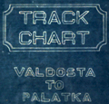 | Details | Georgia Southern and Florida Railway | 1916 |
| Track Chart Valdosta GA to Palatka FL for Georgia Southern and Florida Railway |
|
Georgia Southern and Florida Railway |
|
| 1916 |
| LOC:300 |
| $350.00 | Georgia-Southern-and-Florida-Railway | Track-Chart-Valdosta-GA-to-Palatka-FL-for-Georgia-Southern-and-Florida-Railway | Rare unrecorded cyanotype accordion-folded track chart or track profile (1916) for the <b>Georgia Southern and Florida Railway</b> over their Valdosta, Georgia to Palatka, Florida line. Measures more than 16 feet long. Railroad track charts are very rare and comprise an often-overlooked source for detailed geographic data that is unavailable elsewhere. Published January, 1916 with a MS note on the title page that the ballast is corrected to December 31, 1917.
<br></br>
The blueprint track chart was produced for internal use in the railway Engineering and Maintenance Office and thus may be the only copy remaining. Provides an unique source of detailed data for the railroad line which could be combined with existing cartographic data to enable father analysis.
<br></br>
Data includes railroad milepost numbers, track elevation, track grade, ballast composition (earth or cinders), track weight per linear yard, and geographical features. Notes features along the route including passenger stations, freight depots, water stations, coal stations, trestles, drains, culverts, and stock pens.
<br></br>
Please enquire for complete photographs of this 16' track chart. |
| 5025 |  | Details | Florida State Road Department | 1955 |
| Lot of 14 Florida County General Highway and Transportation Maps |
|
Florida State Road Department |
|
| 1955 |
| LOC:0 |
| $900.00 | Florida-State-Road-Department | Lot-of-14-Florida-County-General-Highway-and-Transportation-Maps | Lot of fourteen (14) transportation maps of Florida, published by the Florida State Road Department, Traffic Planning Division in coordination with the U.S. Department of Commerce Bureau of Public Roads. Mid 20th-century.
<br></br>
<b>General Highway and Transportation Maps:</b>
<div class="indenttextblocksingle">
<ul style="list-style-type: circle;">
<li>Lafayette County. 1936 Revised 1956. </li>
<li>Madison County. 1936 Revised 1955.</li>
<li>Suwannee County. 1936 Revised 1956.</li>
</ul>
</div>
<b>General Highway Maps:</b>
<div class="indenttextblocksingle">
<ul style="list-style-type: circle;">
<li>Baker County. 1955.</li>
<li>Palm Beach County. 1949. 3 of 4 sheets. </li>
<li>Bay County. 1956. 2 of 2 sheets. </li>
<li>Calhoun County. 1949.</li>
<li>Bradford County. 1951 / 1956. </li>
<li>Dade County. 1952 / 1956. Supplemental sheet.</li>
<li>Flagler County. 1948. </li>
<li>Union County . 1951 / 1956. </li>
<li>Liberty County. 1953. </li>
<li>Escambia County. 1956. Supplemental sheet. </li>
<li>Washington County. 1951 / 1956. </li>
</ul>
</div> |
| 5026 |  | Details | Carr and McFadden, Inc. | 1927 |
| Map and Brochure for Palm Beach Regatta 1927 |
|
Carr and McFadden, Inc. |
|
| 1927 |
| LOC:87 |
| $365.00 | Carr-and-McFadden--Inc- | Map-and-Brochure-for-Palm-Beach-Regatta-1927 | Map (9" x 12") and booklet for the Washington's Birthday Regatta on Lake Worth. Palm Beach Yacht Club, 1927. Florida. Map shows the course of the Regatta races. Very scarce.
<br></br>
33 pages with advertisements, race rules, race history, and members of the Palm Beach Regatta Association.
<br></br>
Map drawn by Carr & McFadden, Inc. Civil Engineers in West Palm Beach Florida. |
| 5029 |  | Details | Anonymous | 1960 |
| Map and Brochure New Uncle Sam Cruise Tour Biscayne Bay Florida |
|
Anonymous |
|
| 1960 |
| LOC:11 |
| $80.00 | Anonymous | Map-and-Brochure-New-Uncle-Sam-Cruise-Tour-Biscayne-Bay-Florida | Brochure for a 2.5 hour touristic cruise of Biscayne Bay, Miami Beach, Florida aboard the glass-enclosed motorboat Uncle Sam. With a map of the path of the cruise (in red) around Biscayne Bay.
<br></br>
The diesel-powered 84-passenger Uncle Sam departed Pier 10 at the Miami Yacht Basin in Bayfront Park and passed the Venetian Islands, the Flagler Memorial, Fisher's Island then crossed the Rickenbacher Causeway. On the return to the yacht basin the Uncle Sam passed the bayfront estates of James Deering (Villa Viscaya), Charles Coryell, Damon Runyon, and more.
<br></br>
Detailed inset map of access roads and parking for the Uncle Sam cruise. Multi-lingual brochure ca. 1960's with key details translated and targeted to appeal to a Spanish-speaking audience: "Mostrando especialmente las mansiones de Cubanos y Portorriquenos en la zona residential…"
<br></br>
Printed on both sides and folds to 4" x 9". |
| 5016 |  | Details | Silver Springs Transportation Company | 1924 |
| Map of Silver Springs Daylight Route Cruise Ocklawaha River |
|
Silver Springs Transportation Company |
|
| 1924 |
| LOC:11 |
| $295.00 | Silver-Springs-Transportation-Company | Map-of-Silver-Springs-Daylight-Route-Cruise-Ocklawaha-River | Florida 1920's land-boom era map of Silver Springs Daylight Route cruise over the Silver River, Ocklawaha River, and St. John's River Florida, a distance of 135 miles. Map is one page in a folded brochure "Daylight Route Ocklawaha River" produced by the Silver Springs Transportation Company for the 1923-24 season. For more than a century tourism and transportation have both greatly contributed to Florida's growth. The map, supported by the rest of the brochure, details the route, landings, and sights for one of three boats operated by the Silver Springs Transportation Company the "City of Ocala", "Silver Springs", and "Wekiwa".
<br></br>
During the season two trips were offered daily, six days a week with one boat traveling from Silver Springs to Palatka and the other from Palatka to Silver Springs. Map identifies important points along the trip including Gore's Landing, Hell's Half Acre, Forty Feet Cliff, Fort Brooks, McBride's landing and many more. |
| 5012 | 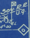 | Details | Atlantic Coastline Railroad Company | 1939 |
| Lot of 2 very rare Atlantic Coastline Railroad Florida Track Charts |
|
Atlantic Coastline Railroad Company |
|
| 1939 |
| LOC:0 |
| $950.00 | Atlantic-Coastline-Railroad-Company | Lot-of-2-very-rare-Atlantic-Coastline-Railroad-Florida-Track-Charts | Lot of two rare condensed books of profile maps, or track charts providing unique, detailed data for a cross-section of Florida traversed by the Atlantic Coastline Railway. The two books were intended for use only within the railway system and include:
<div class="indenttextblocksingle">
<ul style="list-style-type: circle;">
<li>Northbound and southbound mainline of the Atlantic Coast Line Railroad Company between Richmond, Virginia and Jacksonville, Florida.</li>
<li>Track charts of A. C. L. R. R. feeder lines including Dunnellon to Wilcox, Trilby to St. Petersburg, Uceta to Tampa, and other routes.</li>
</ul>
</div>
By the Office of the Chief Engineer for the Atlantic Coast Line Railroad Company ca. 1938. Profiles are printed via the cyanotype process (blueprint). Numerous manuscript edits in red to maintain track profiles and routes current over time.
<br></br>
Provides a mile by mile detailed record of the path of the A.C.L.R.R. as it made its way south along the Atlantic Coast region and within Florida, for the routes noted above. Most of the data provided in these profiles are unavailable elsewhere and include:
<div class="indenttextblocksingle">
<ul style="list-style-type: circle;">
<li>Track weight per linear foot and year track was laid</li>
<li>Milepost number</li>
<li>Direction of the line via compass heading for sub-segments of the line</li>
<li>Slope of the grade for each sub-segment</li>
<li>Details about every opening beneath the railway including drainage pipes, bridges, arches, and boxes</li>
<li>County boundaries</li>
<li>Town and village names</li>
<li>Locations of railway infrastructure (freight depots, passenger stations, and signals) </li>
</ul>
</div>
Charts are paginated in booklet format. Charts are blank on verso. |
| 5005 | 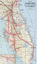 | Details | Seaboard Air Line Railway | 1927 |
| Map of Seaboard Airline Railway and Connections |
|
Seaboard Air Line Railway |
|
| 1927 |
| LOC:61 |
| $425.00 | Seaboard-Air-Line-Railway | Map-of-Seaboard-Airline-Railway-and-Connections | Map of Seaboard Airline Railway and Connections. Covers the route along the United States East Coast from Virginia, through the Carolinas to Florida. Verso blank.
<br></br>
Folds into card stock folder with a List of Stations and Index to locations on map. Issued by the Freight Traffic Department, Norfolk, Virginia. June, 1927.
<br></br>
Printed by the Whitney Graham Co. Inc. Buffalo and New York City. |
| 4994 | 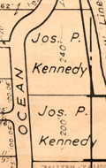 | Details | Brockway, George S. | 1936 |
| Lot of 3 maps Palm Beach Atlas Florida MS notes |
|
Brockway, George S. |
|
| 1936 |
| LOC:11 |
| $525.00 | Brockway--George-S- | Lot-of-3-maps-Palm-Beach-Atlas-Florida-MS-notes | Lot of three (3) scarce cadastral maps from the Palm Beach, Florida Atlas ca. 1936 by Civil Engineer George S. Brockway. Data printed on each sheet include tract/development name, deed reference location, lot dimensions, street names and lot number.
<br></br>
Sheets may contain manuscript pencil notations (ca. 1947 / 1948) with additional property owner names, property prices and indications of whether there was a structure on the property. Verso of each sheet contains Brockway's ink-stamped disclaimer of legal responsibility.<br></br>
<b>Details for the three atlas plates include</b>
<div class="indenttextblocksingle">
<ul style="list-style-type: circle;">
<li>Sheet 5: Covers an area bounded by Merrain Road (N), La Puerta Way (S), Lake Worth (W), Atlantic Ocean (E). Developments include the Bello Lido, Alto Lido and Mockingbird Trail tracts. </li>
<li>Sheet 6: Covers and area bounded by La Puerta Way (N), Orange Grove Road (S) - Lake Worth (W) Atlantic Ocean (E). Includes developments of Palm Beach Shores, Gregory Addition and the New Siears tracts. Shows the former <b>Kennedy Estate with two lots owned by Joseph P. Kennedy</b> totaling 440 feet of ocean frontage.</li>
<li>Sheet 15-A: Bounded by Seminole Ave (N), Royal Poinciana Way (S), Lake Worth (W), North County Road (E) Includes the Flagler Memorial Bridge, old <b>Biltmore Hotel and the Beach Club</b>. Developments include Ocean Park, Floral Park, and Bungalow Park.</li>
</ul>
</div> |
| 4996 | 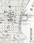 | Details | Young, George F. | 1925 |
| St Petersburg Florida map issued by the CoC |
|
Young, George F. |
|
| 1925 |
| LOC:87 |
| $325.00 | Young--George-F- | St-Petersburg-Florida-map-issued-by-the-CoC | Map of St Petersburg, Florida drawn by engineer George F. Young and issued by the St. Petersburg Chamber of Commerce in 1925. Verso with an oblique birds-eye photo view of St. Petersburg, Florida looking toward land from offshore. Scarce.
<br></br>
George F. Young, Inc. is one of the oldest Florida engineering and surveying companies, established in 1919. Today G.F. Young, Inc. has professional offices located in St. Petersburg, Tampa, Lakewood Ranch, Gainesville, and DeBary, Florida
<br></br>
Shows the Coffee Pot Golf Club. In 1920, St. Petersburg developer, C. Perry Snell opened a 9-hole golf course along Coffee Pot Bayou called the <b>“Coffee Pot Golf Club.”</b> In 1926, Snell hired golf architects, Wayne Stiles and John van Kleek to build a modern 18-hole golf course. It was renamed the Snell Island Golf Course. In 1948, , known as Sunset Golf and Country Club, the operation was purchased by the Alsonett Hotel Corporation, and re-named the <b>Vinoy Golf Club.</b>
<br></br>
During February, 2019 Vinoy Golf Club was featured as Florida Historic Golf Trail Course of the Month by the Florida Department of State.
<br></br>
Publisher's colophon reads : "Map prepared in office of G.F. Young Civil and Landscape Engineer Drafting and Blueprints 633 Central Ave. St. Petersburg Fla." [FL. Fla.] |
| 4882 |  | Details | Sutherland, McConnel and Co. | 1911 |
| Fine Original Broadside for Florida Land Speculators |
|
Sutherland, McConnel and Co. |
|
| 1911 |
| LOC:61 |
| $695.00 | Sutherland--McConnel-and-Co- | Fine-Original-Broadside-for-Florida-Land-Speculators | <br></br>
<div style="text-align: center;font-size:125%;">
"Successful Men Do It Now - <br />Failures Wait Until Tomorrow"
</div>
<BR />
An original antique advertising broadside from the early Florida land boom. A fine, surviving 18" x 24" lithographed copy on thin paper, touting the opportunity that awaited the investor in Florida real estate, including 27,000 acres ("the best tract for farming") near Jacksonville, in Duval County. A fine piece of ephemera that supports and extends any collection of Florida cartography or the history of the Southeast.
<br></br>
The artifact could be considered as the "poster child" of antique Florida ephemera as the two tear-out coupons strongly suggest the broadside was not expected to have a long life and would be discarded after use.
<br></br>
"Virgin Soil", "Pure Water", "1,000,000 Acres to Choose From", "Healthful Climate", "Big Crops".
<br></br>
Offered at prices from $12.50 to $30.00 per acre by the Colonization Department of the partnership of Sutherland, McConnel & Co. of Jacksonville, Florida, Clifford Greve, General Manager. The Auck Brothers of Bucyrus, Ohio were appointed as "Special Agents" for the sale. |
| 4821 | 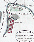 | Details | Jefferys, Thomas | 1770 |
| Rare Original Antique Chart of Amelia Island, Florida and Vicinity |
|
Jefferys, Thomas |
|
| 1770 |
| LOC:61 |
| $4,000.00 | Jefferys--Thomas | Rare-Original-Antique-Chart-of-Amelia-Island--Florida-and-Vicinity | Scarce engraved, hand-colored British navigation chart from 1770 containing three maps of Amelia Island, the Nassau River, Talbot Island and Cumberland Island, Georgia on the same sheet:
<div class="indenttextblocksingle">
<ul style="list-style-type: circle; ">
<li><b>Plan of Amelia Island in East Florida.</b> Based on an earlier survey by military engineer, surveyor, and cartographer John William Gerard de Brahm. De Brahm is known publishing “A Map of South Carolina and a Part of Georgia” in 1857.</b></li>
<li><b>A Chart of the Entrance to the St. Mary's River taken by Captn. W. Fuller.</b></li>
<li><b>A Chart of the Mouth of Nassau River and the Soundings on it taken at Low Water by Captn. W. Fuller.</b></li>
</ul>
</div>
Dedicated to John Earl of Egmont by William Fuller. Published by Thomas Jefferys, London, March 1770. |
| 4800 | 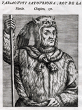 | Details | Thevet, Andre | 1584 |
| Portrait of the King of Florida Paraousti Satouriona |
|
Thevet, Andre |
|
| 1584 |
| LOC:87 |
| $450.00 | Thevet--Andre | Portrait-of-the-King-of-Florida-Paraousti-Satouriona | Fine antique portrait of Paraousti Satouriona, styled the <b>"King of Florida",</b> and dressed in a thick animal skin, wearing a head-dress made from what is apparently the skull and head of a lynx, with the front legs and claws stylishly knotted about the King's neck.
<BR> </BR>
This scarce engraving comes from "Les vrais pourtraits et vies des hommes illustres grecz, latins et payens" by Andre Thevet. That source contained a collection of over two hundred portraits and biographies of subjects such as Montezuma, Atahualpa, Cortez, Paracoussi "Roy du Platte", and this Paraousti Satouriona the "Roy de La Floride" .
<BR> </BR>
Andre Thevet, born around 1516, became a Franciscan friar and wrote extensively about his travels in both the old world and new, widely embellishing the stories and images with myth and fiction.
<BR> </BR>
French text on verso and recto. Page 661. |
| 4774 | 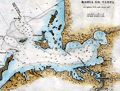 | Details | Direccion Hidrografia | 1818 |
| Scarce antique Spanish chart of Tampa Bay, Florida |
|
Direccion Hidrografia |
|
| 1818 |
| LOC:200 |
| $1,650.00 | Direccion-Hidrografia | Scarce-antique-Spanish-chart-of-Tampa-Bay--Florida | A scarce Spanish antique nautical chart of a large area now encompassing St. Petersburg and Tampa, Florida, and all of Tampa Bay. With anchorages identified, depth soundings, and several Spanish place-names. One unidentified location, "Cayo de Aguada" or Watering Key, remains unknown to me. That location likely would have been very attractive to pirates and privateers as it offered both close proximity to fresh water and to the nearby deeper entrance channels to Tampa Bay.
<br></br>
Contains numerous coastal locations with their second-Spanish period names: Longboat Key ("Id. Larga"), Passage Key ("Cayo del Passage"), Sweetwater Creek ("Rio de Aguadulce"), Little Manatee River ("Rio de Manaties"), Point Pinellas (Punta de Pinar [Sp. pine]). During the research for Spanish place-names our search turned up an exact match for "Punta de Piedras" or Rocky Point on the northeast shore of Old Tampa Bay. Unfortunately, that location for "Punta de Piedras" is on the wrong side of the bay. The search continues.
<br></br>
From the second part of "Portolano de la America...", published in 1818 by Spain's Admiralty department, the Dirección de Hidrografía. In 1809 the Direccion first published this atlas of plans of bays, harbors, and ports from Spain’s New World possessions: "Portolano de la America Septentrional Construido en la Direccion de Trabajos Hidrograficos". Plate 36. |
| 4770 | 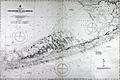 | Details | British Admiralty Hydrographical Office | 1920 |
| Large Antique Chart of The Florida Keys |
|
British Admiralty Hydrographical Office |
|
| 1920 |
| LOC:61 |
| $1,375.00 | British-Admiralty-Hydrographical-Office | Large-Antique-Chart-of-The-Florida-Keys | Fine antique British Admiralty sea chart with cartographic coverage of the islands of the <b>Florida Keys</b>. Hydrographic data on this early 1866 British navigational chart extend past Key West. Though updated to 1920, this scarce survivor retains the appearance of a 19th-century British copperplate-engraved nautical chart, a visual charm more recent charts do not generally possess.
<br></br>
An inset diagram shows an example <b>navigational beacon</b>, made of iron, 36 feet in height and carrying an identifying letter within a moveable vane. These beacons, or day marks, delineated the southern boundary of the Florida Keys. The accompanying note states:
<br></br>
<div class="indenttextblock">
<img src="/PageImages/Beacon for 4770.jpg" alt="Florida keys navigational beacons (day marks)" width="120" align="left" style="margin: 0px 20px">
"The Beacons marking the outer Florida Reefs are distinguished by Letter or Numbers in the vane which each carries, commencing off Key West and proceeding in alphabetical or numerical order toward Cape Florida. With the exceptions of that American Shoal which is brown and that on Fowey Rock which is black, the Beacons are all painted white. These beacons are likely to be washed away."
</div>
<br></br>Manuscript notations in pencil from a previous owner record eight of the beacons as "damaged."
<br></br>
This chart of Lower Matacumbe Cay to Boca Grande Cay should be treasured by anyone with interests in fishing, sailing, or boating in the Florida Keys.
<br></br>
After U.S. Coast Survey charts from the last half of the 19th century. First published by the British Admiralty on July 18, 1866, with several editions and later corrections after, the last correction in 1920. Originally sold by J.D. Potter, agents, London. Chart no. 1098. |
| 4746 | 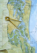 | Details | Leary, Pat | 1987 |
| Limited edition print of Amelia Island, Florida |
|
Leary, Pat |
|
| 1987 |
| LOC:61 |
| $175.00 | Leary--Pat | Limited-edition-print-of-Amelia-Island--Florida | Signed and numbered decorative limited-edition nautical print of the coast near <b>Amelia Island, Florida</b>. This fine modern print features a 20th-century Coast Survey chart of the Atlantic Coast in that area overlaid with a eighteenth-century "Plan of Amelia Island in East Florida" by Fuller/Jefferys. With images of shrimp boats, nets and other artifacts that evoke the laid-back low-country charm of that area.
<br></br>
Signed in pencil and dated within to 1987. Number 399/500.
<br></br>
A fine original gift for those with interests in boating, fishing, or beach recreation in the area near Amelia Island or the Florida Altantic Coast. |
| 3642 | 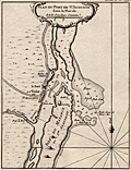 | Details | Bellin, Jacques Nicolas | 1764 |
| Neat French antique map of St. Augustine, Florida and harbor. |
|
Bellin, Jacques Nicolas |
|
| 1764 |
| LOC:87 |
| $400.00 | Bellin--Jacques-Nicolas | Neat-French-antique-map-of-St--Augustine--Florida-and-harbor- | Fine small French navigation chart of the port and harbour of St. Augustine, Florida ca. 1764 from Bellin's "Petit Atlas Maritime". Anastasia Island, directly offshore the harbor is titled "Isle de Matance ou St. Anastasie". Shows the entrance to the harbor encircled by shallow sand-banks with a tower ("balise") serving as a navigational aid. Other features noted by Bellin include an "Eglise des Indiens" or church for native americans; the fort- Castillo de San Marcos; a monastery; the "Riviere Diego" now the Tolomato River; and "Riviere St. Sebastien" .
<br></br>
From J.N. Bellin's master work <b>Le Petit Atlas Maritime</b> . North is oriented to the top. Uncolored. Tome I, No. 39. |
| 3618 |  | Details | U.S. Coast and Geodetic Survey | 1849 |
| Reconnaissance of Pensacola and Perdido Bays |
|
U.S. Coast and Geodetic Survey |
|
| 1849 |
| LOC:11 |
| $120.00 | U-S--Coast-and-Geodetic-Survey | Reconnaissance-of-Pensacola-and-Perdido-Bays | Small coastal survey chart of Florida from Bonsecour Bay to the east end of Santa Rosa Island. Includes Pensacola Bay, Escambia Bay, Garcon Point, Blackwater River, Perdido Beach, Mast Bay, Forster's Island, and Fort Pickens. <strong>Price includes hand coloring.</strong>
<br><br>
Chart shows the triangulation network employed in an early survey conducted by the U.S. Coast [and Geodetic] Survey in 1849. Changes in topography inland are indicated by hachuring.
<br></br>
In surveying, triangulation is the process of determining the location of a point by measuring only angles to it from known points at either end of a fixed baseline. The point can then be fixed as the third point of a triangle with one known side and two known angles. Surveying error is minimized if first a mesh of triangles is created at the largest appropriate scale. Then points inside the triangles can all then be accurately located with reference to the triangulation network. |
| 2565 | 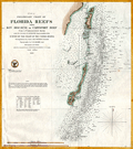 | Details | U.S. Coast and Geodetic Survey | 1855 |
| Preliminary Chart of Florida Reefs from Key Biscayne |
|
U.S. Coast and Geodetic Survey |
|
| 1855 |
| LOC:200 |
| $475.00 | U-S--Coast-and-Geodetic-Survey | Preliminary-Chart-of-Florida-Reefs-from-Key-Biscayne | Fine antique hydrographic survey chart of <b>Biscayne Bay</b>, Florida and surrounding area. Hundreds, perhaps thousands of depth soundings.
<br></br>
Miami, Florida is distinctly noted at the very top while a lighthouse is noted at the southern tip of Cape Florida. Other named features include: Old Rhodes Bank, Caesars Creek Bank, Elliott's Key, Triumph Reef, and Virginia Key.
<br></br>
Recommended reference for <b>treasure hunters</b>. Shows some locations of wrecks, dangerous reefs and banks.
<br></br>
Includes a list of abbreviations used to denote the sea floor composition (ex: S for Sand , C for clay).
<br></br>
A preliminary reduced-format hydrographic survey chart from a U.S. Coast Survey atlas with the U.S.C.G.S. circular winged logo. On thin paper with folds as issued. |
| 2564 | 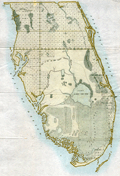 | Details | Anonymous | 1858 |
| Map of the Florida Peninsula |
|
Anonymous |
|
| 1858 |
| LOC:87 |
| $180.00 | Anonymous | Map-of-the-Florida-Peninsula | Very attractive antique map of the Florida Peninsula from 1858. Shows status of surveys below the 2nd basis parallel conducted to that date. |
| 2482 |  | Details | Moll, Herman | 1709 |
| Mexico, or New Spain With Guadalajara, Guatemala, and Florida |
|
Moll, Herman |
|
| 1709 |
| LOC:3 |
| $500.00 | Moll--Herman | Mexico--or-New-Spain-With-Guadalajara--Guatemala--and-Florida | A map dealer's map!! I love it!
<br></br>
Hermans Moll's classic map of the United States, Caribbean, and Central America. Moll has divided the area into the four provinces of Mexico, Guadalajara Guatemala, and Florida. Pacific Ocean is labeled "The Great South Seas"; the Gulf of Mexico is sub-titled "the Bay of Mexico". Beginning of Chapter VII. Page 214. English text on verso. |
| 1457 |  | Details | Gold, Joyce | 1804 |
| Chart of the Supposed Course of the Florida Stream |
|
Gold, Joyce |
|
| 1804 |
| LOC:3 |
| $400.00 | Gold--Joyce | Chart-of-the-Supposed-Course-of-the-Florida-Stream | Graphically arresting thematic chart of the "Florida Stream" or Gulf Stream with its flow northwards up the east coast of the United States, well past Bermuda, and then into the North Atlantic Ocean. Direction of the Gulf Stream current is shown visually by arrows supplemented with written notations indicating the compass direction at several locations across the stream.
<br></br>
The map may be considered to be an example of persuasive cartography. The concept of the Gulf Stream was novel at that time (hence the "supposed"); many mariners had not fully adopted the notion when this map was published. The direction and flow of the Gulf Stream was proposed by Benjamin Franklin in 1770 based on measurements he took during voyages from the U.S. to England and France.
<br></br>
London Published May 31, 1804 by J. Gold, 103 Shoe Lane. |
| 1369 | 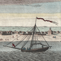 | Details | Tirion, Isaac | 1767 |
| Very early view of Pensacola, Florida from 1767 |
|
Tirion, Isaac |
|
| 1767 |
| LOC:11 |
| $260.00 | Tirion--Isaac | Very-early-view-of-Pensacola--Florida-from-1767 | Antique elevation view of Pensacola, Florida on the Florida Panhandle. This attractive engraved view documents the very few structures that existed in that Gulf of Mexico port 250 years ago just after the end of Spanish rule over the city. German text.
<br></br>
From the English-language edition of this view we learn the names of six objects or locations on the view: 1. The Fort. 2. The Church. 3. The Governor's House. 4. The Commandant's House. 5. A Well. 6. A Bungo. (A bungo was a type of boat or canoe used in the southern United States made of a hollowed-out tree.)
<br></br>
This engraving is the one of the earliest available printed views of Pensacola.
<br></br>
After Dominic Serres (1719-1793), a French-born painter primarily of nautical or maritime subjects. Serres was assigned to the Brtitish expedition to capture Havana, led by Admiral Sir George Pocock. It is possible that Serres visited Pensacola during that cruise. |
| 1358 | 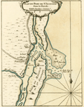 | Details | Bellin, Jacques Nicolas | 1764 |
| Antique mid-eighteenth century chart of the harbor of St. Augustine, Florida |
|
Bellin, Jacques Nicolas |
|
| 1764 |
| LOC:11 |
| $475.00 | Bellin--Jacques-Nicolas | Antique-mid-eighteenth-century-chart-of-the-harbor-of-St--Augustine--Florida | Fine small French navigation chart of the port and harbour of St. Augustine, Florida ca. 1764 from Bellin's "Petit Atlas Maritime". Anastasia Island, directly offshore the harbor is titled "Isle de Matance ou St. Anastasie". Shows the entrance to the harbor encircled by shallow sand-banks with a tower ("balise") serving as a navigational aid. Other features noted by Bellin include an "Eglise des Indiens" or church for native americans; the fort- Castillo de San Marcos; a monastery; the "Riviere Diego" now the Tolomato River; and "Riviere St. Sebastien"
<br></br>
Tome I No 39. |
| 1323 | 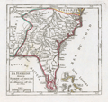 | Details | Vaugondy, Robert de | 1749 |
| Interesting antique map of Florida and the Carolinas |
|
Vaugondy, Robert de |
|
| 1749 |
| LOC:11 |
| $280.00 | Vaugondy--Robert-de | Interesting-antique-map-of-Florida-and-the-Carolinas | Attractive and fascinating map of south-eastern United States with "Virginie, Caroline, Louisiane, and Floride". Named features include Pensacola, the Bahama Islands, Cape Canaveral, St. Augustine, Saint Simons Island, Tybee Island, Savannah, Charleston, Cape Fear, and the "Montagnes de Apalaches". Florida is depicted as an archipelago of islands as some sources believed at the time. Published by the family of Robert Vaugondy in 1749.
<br></br>
This scarce map is an authentic French copper-plate engraving printed ca. 1749 on a larger 11" x 8.5 inch sheet of old chain-laid paper. |
| 1290 | 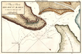 | Details | Direccion Hidrografia | 1818 |
| Scarce Spanish chart of north Amelia Island and St. Marys River bar. |
|
Direccion Hidrografia |
|
| 1818 |
| LOC:200 |
| $1,350.00 | Direccion-Hidrografia | Scarce-Spanish-chart-of-north-Amelia-Island-and-St--Marys-River-bar- | A scarce Spanish nautical chart of the mouth (boca) and bar (barra) of the Saint Mary's River, Florida. A scholarly summary of the map from the University of Miami notes the rarity of this small antique chart:
<div class="indenttextblock">
"This <b>rare map</b> shows the St. Marys River, which is the northern border of eastern Florida. It is from a Spanish portfolio showing harbor areas in its last colony in North America's eastern portion. <b>Very few maps are available that were made by them in the second Spanish Period</b>." <a href="http://scholar.library.miami.edu/floridamaps/view_image.php?image_name=dlp00020000860001001&group=cartographer" target="_blank">Internet. </a>
</div>
No record of the sale of the "Rio Santa Maria" map is reported in the Antique Map Price Record.
<br></br>
Includes portions of Fernandina Beach and north Amelia Island, Florida; Little Tiger Island, Florida; and south Cumberland Island Georgia.
<br></br>
Over 200 years ago, this chart of the bar with depth soundings, would have been very useful to mariner's entering or departing the St. Marys river. Shows "Fort Arruinado" ( Fort William ) on the southern tip of Cumberland Island.
<br></br>
The St. Marys River is a remote blackwater stream, located in southeastern Georgia and northeastern Florida, forming the easternmost border between the two states. The St. Marys serves as critical habitat for numerous rare, threatened or endangered species.
<br></br>
From the second part of "Portolano de la America...", published in 1818 by Spain's Admiralty department, the Dirección de Hidrografía. In 1809 the Direccion first published this atlas of plans of bays, harbors, and ports from Spain’s New World possessions: "Portolano de la America Septentrional Construido en la Direccion de Trabajos Hidrograficos". (Updated in 1818). Plate 40. |
| 1291 | 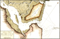 | Details | Direccion Hidrografia | 1818 |
| Antique Spanish chart of the mouth of St. Johns River, Florida |
|
Direccion Hidrografia |
|
| 1818 |
| LOC:200 |
| $1,325.00 | Direccion-Hidrografia | Antique-Spanish-chart-of-the-mouth-of-St--Johns-River--Florida | A scarce Spanish nautical chart by the Direccion Hidrografia of the mouth (boca) and bar (barra) of the Saint Johns River, Florida near Jacksonville. A scholarly summary by the the University of Miami of a similar map notes the rarity of these early antique Spanish charts:
<div class="indenttextblock">
"It is from a Spanish portfolio showing harbor areas in its last colony in North America's eastern portion. <b>Very few maps are available that were made by them in the second Spanish Period</b>." <a href="http://scholar.library.miami.edu/floridamaps/view_image.php?image_name=dlp00020000860001001&group=cartographer" target="_blank">Internet. </a>
</div>
<br></br>
North is oriented at the upper right.
<br></br>
The St. Johns is the longest river in Florida - 310 miles long. It is one of the few rivers in the United States that flows north. The source of the river is a large marshy area in Indian River County that flows north and turns eastward at Jacksonville, FL to its mouth in the Atlantic Ocean.
<br></br>
From the second part of "Portolano de la America...", published in 1818 by Spain's Admiralty department, the Dirección de Hidrografía. In 1809 the Direccion first published this atlas of plans of bays, harbors, and ports from Spain’s New World possessions: "Portolano de la America Septentrional Construido en la Direccion de Trabajos Hidrograficos". (Updated in 1818). Plate 40. |
| 1232 | 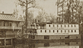 | Details | Colby, C. H. | 1895 |
| Antique Cabinet Card of Steamboat Okeehumkee at Silver Springs, Florida |
|
Colby, C. H. |
|
| 1895 |
| LOC:0 |
| $175.00 | Colby--C--H- | Antique-Cabinet-Card-of-Steamboat-Okeehumkee-at-Silver-Springs--Florida | Large antique cabinet card of the steamer Okeehumkee docked at the Silver Springs' Florida landing, moss-covered trees in the background. The Okeehumkee, also known as "Queen of the Ocklawaha River," was a 84' x 21'river steamboat that provided transportation along Florida rivers in the late 19th century. The Okeehumkee was equipped with a paddle wheel positioned in the lower stern part of the boat which allowed it to traverse narrow and shallow rivers.
<br></br>
The steamer Okeehumkee was built in 1873 by Hubbard Hart, founder of the Ocklawaha Navigation Company's Hart's Line, at his East Palatka Hart's Point shipyard. It was named after a Native American chief from the area of the Ocklawaha lakes. The boat was outfitted with shutters on the windows to keep tree branches out and a livestock pen at the rear of the boat, on the upper deck. The boat was altered several times throughout its service lifetime. In 1893, a second deck of cabins was added. In 1919, Hart's Line ceased operation and the Okeehumkee was moored at Hart's Point shipyard in East Palatka.
<br></br>
In 1883 Lady Duffus Hardy published a <a href="https://books.google.com/books?id=-Iw-AAAAYAAJ&printsec=frontcover&dq=inauthor:%22Lady+Duffus+Hardy%22&hl=en&sa=X&ved=0ahUKEwjJvM-_nNHTAhXQZiYKHWdED4sQ6AEIJzAA#v=onepage&q&f=false" target="_blank">vivid account</a> of her trip aboard the Okeehumkee on the Oklawaha River from Silver Springs, Florida to Palatka. Lady Hardy relates how pine logs were burned in a large cauldron at the top of the vessel to provide illumination at night. "Now the blue flame flashes up to the great tree tops, then darts downward like a fiery serpent, and up some winding water lane, and for a second, a thousand weird forms float before our eyes, and change and fade and melt into nothingness." |
| 1167 | 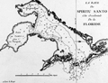 | Details | Le Rouge, George | 1778 |
| Scarce early nautical chart of Tampa Bay, Florida |
|
Le Rouge, George |
|
| 1778 |
| LOC:200 |
| $1,500.00 | Le-Rouge--George | Scarce-early-nautical-chart-of-Tampa-Bay--Florida | Fine and very scarce copper-plate engraved harbor chart of the "Baye du Spiritu Santo" comprised of "Bay de Tampa" and the "Baye de Hillsborough", by George le Rouge, from Paris. Coverage on this fine historic French nautical artifact covers areas in Florida that are today's <b>St. Petersburg, Tampa, Brandon, Bradenton and Sarasota</b>. Only one sale recorded in AMPR, 28 years ago.
<br></br>
Le Rouge noted only a few key features including: two references to "Eau douce" (Trans. 'sweet water'); a location noted as "Black Rocks"; "Egmont Island"; and "Long Island" (today's Longboat Key).
<br></br>
From Pilote américain septentrional by <b>George le Rouge</b>, this is one of the <b>earliest available large-scale nautical charts of Tampa Bay</b> with the entrance to the Gulf of Mexico. Rouge's Pilote américain septentrional drew heavily upon the work of William Faden and Thomas Jefferys. The maps were modified with French nomenclature but their British origin explains why some place names are in English. Latitude is noted but no metrics exist for longitude. Distance scale is in English miles. Manuscript number "27" in upper right. |
| 1145 | 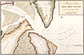 | Details | Direccion Hidrografia | 1818 |
| Boca y Barra Del Rio Nasau |
|
Direccion Hidrografia |
|
| 1818 |
| LOC:200 |
| $1,475.00 | Direccion-Hidrografia | Boca-y-Barra-Del-Rio-Nasau | Rare Spanish nautical chart of the mouth (boca) and bar (barra) in Nassau Sound, Florida in 1818. One of the earliest available large-scale charts of the entrance to the Nassau River and the coastal margins near that waterway which divides Amelia Island from Talbot Island.
<br></br>
From the second part of "Portolano de la America Septentrional Construido en la Direccion Detrabajos Hidrograficos" published in 1818 by Spain's Admiralty department, the
<a href="https://www.rarecharts.com/DireccionHidrografiaBackground.aspx " target="_blank">Dirección de Hidrografía. </a> Plate 326. |
| 1076 | 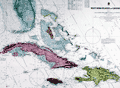 | Details | British Admiralty Hydrographical Office | 1926 |
| Antique British Chart of the Caribbean Sea and West Indies |
|
British Admiralty Hydrographical Office |
|
| 1926 |
| LOC:61 |
| $750.00 | British-Admiralty-Hydrographical-Office | Antique-British-Chart-of-the-Caribbean-Sea-and-West-Indies | Spectacular large and original early twentieth-century nautical chart of south Florida and the Caribbean. Points in the USA include towns south of Orlando: Tampa, Cape Canaveral, Key West , Lake O-kee-cho-bee, and much more. Includes the islands of Jamaica, Cuba, Hispaniola, the Bahamas, Turks and Caicos. Hundreds of soundings and navigational hazards are identified.
<br></br>
Later edition of a British Admiralty chart first engraved and published from London in 1876. This bold, dark print retains the cartographic look and style of the late 19th century with updated hand-coloring by a professional map colorist. More recent charts do not display the character of this beauty.
<br></br>
Oval logo of the British Hydrographical office at upper right. Price when sold was three shillings. Chart number 761. Sold by J.D. Potter. |
| 896 | 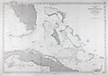 | Details | Depot de la Marine | 1873 |
| Antique French Chart of the Straits of Florida and Bahamas |
|
Depot de la Marine |
|
| 1873 |
| LOC:1111 |
| $900.00 | Depot-de-la-Marine | Antique-French-Chart-of-the-Straits-of-Florida-and-Bahamas | Attractive antique French navigation chart covers the <b>Strait of Florida</b>, Grand Bahama Bank, Little Bahama Bank, and much of Cuba. Originally released in 1865 this edition was printed with updates in 1873 by France's Depot de la Marine. Includes the Florida Keys, the Tortugas, Great Abaco Island, Grand Bahama Island, Andros Island, and the Bahamian island chain as far south as Great Inagua Island. Named habitations include Tampa, Florida, and Havana, Cuba.
<br></br>
Perhaps the most signifcant feature of the map is the lack of settlements along Florida's east coast. Hydrographic features on the lower east coast include the Indian River, Jupiter Inlet, Biscayne Bay, and Hillsboro Inlet ("Entre de Hillsboro") but the sole settlement is <b>Fort Dallas</b>, established on Key Biscayne by the U.S. Navy in 1836 to prevent trade between the indigenous Seminole Indians and traders from Cuba and the West Indies.
<br></br> Chart is a lithograph, based on U.S. and Spanish precursor charts, produced in 1873 by France's Depot de Cartes et Plans de la Marine, their official hydrographic agency. |
| 557 | 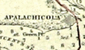 | Details | U.S. Coast and Geodetic Survey | 1914 |
| 1914 Inside Route Pilot Key West to New Orleans |
|
U.S. Coast and Geodetic Survey |
|
| 1914 |
| LOC:2001 |
| $400.00 | U-S--Coast-and-Geodetic-Survey | 1914-Inside-Route-Pilot-Key-West-to-New-Orleans | Very scarce, intact 1914 Coast Pilot with six strip charts and sailing directions for what is now the Gulf Intracoastal Waterway, from Key West, Florida heading north and then west to New Orleans, Louisiana. Published by the U.S. Coast and Geodetic Survey. Contains 93 pages of text plus an index.
<br><br/>
In its early history some portions of the 'inside route' were owned and dredged by private entities who charged a toll to vessels for passage, sometimes by stringing a chain across narrow passages to restrict traffic flow. After 1919 Congress mandated that the entire passage should be turned over to the Federal government and the tolls were eliminated.
<br><br/>
The sailing directions for Bayou St. John describe a moment in time that New Orleans residents can only imagine today: <dir class="indenttextblock">The channel at the entrance is protected by training walls on each side. Spanish Fort is a pleasure resort at the mouth of Bayou St. John and is connected with New Orleans by an electric car line... Small craft of all kinds use the bayou as far as Esplanade Street, about 2 3/4 miles above the entrance, but pleasure boats rarely go above that point." </dir>
Size of each chart when folded is approximately 8" x 5". The pilot's lithographed working navigational charts capture the full extent of the southern U.S. Inside Route in detail. Chart sections include roughly these areas and chart sizes: (fully opened, height is 10" and width is listed below). <br>
1. Key West to Matanzas Pass - 24"<br>
2. Matanzas Pass to Clearwater - 23"<br>
3. Clearwater to Tampa - 27"<br>
4. Tampa to St. Andrews Sound - 24"<br>
5. St. Andrews Sound to Bay St. Louis - 36"<br>
6. Bay St. Louis to New Orleans. - 23"<br>
<br><br/>
If they were placed end to end, the charts would extend over 13 feet long. Original price 20 cents. Published by the Government Printing Office in Washington DC in 1915. |
| 341 |  | Details | U.S. Geological Survey | 1892 |
| Turtle Harbor Florida |
|
U.S. Geological Survey |
|
| 1892 |
| LOC:3 |
| $75.00 | U-S--Geological-Survey | Turtle-Harbor-Florida | Small lithographed antique chart of Key Largo and Turtle Harbor Florida. The chart, from the U.S. Geological Survey, is derived from a U.S. Coast Survey chart and overlaid with hachured topographic details. Lighthouses, soundings, and navigational aids are shown. Water shown in blue. Some of the features shown include Pumpkin Key, Carysfort Reef, Angelfish Key, and Palo Alto Key. <BR> </BR>
Produced for the U.S. Geological Survey Thirteenth Annual Report. Produced by George S. Harris Lithographers, Philadelphia. Plate 36. |
| 343 |  | Details | U.S. Geological Survey | 1892 |
| Delta at Caesars Creek (Florida) |
|
U.S. Geological Survey |
|
| 1892 |
| LOC:3 |
| $75.00 | U-S--Geological-Survey | Delta-at-Caesars-Creek-(Florida) | Small lithographed antique chart of the area around Caesars Creek, on the southeast coast of Florida. The chart, from the U.S. Geological Survey, is derived from a U.S. Coast Survey chart (no. 66) and overlaid with hachured topographic details. Soundings, and navigational aids are shown. Water shown in blue. Some of the features shown include Elliott Key, Rubicon Key, Tottens Key, and Reids Key, Adams Key. <BR> </BR>
Produced for the U.S. Geological Survey Thirteenth Annual Report. Produced by George S. Harris Lithographers, Philadelphia. Plate 42. |