| | Thumbnail | | Creator | Date | Title / Author / Date / Location | Price | | | Description |
| 585 |  | Details | Homann Heirs | 1740 |
| Regni Sinae vel Sinae Propriae |
|
Homann Heirs |
|
| 1740 |
| LOC:0 |
| $0.00 | Homann-Heirs | Regni-Sinae-vel-Sinae-Propriae | SOLD<br></br>Large hand-colored engraved antique map of China ca. 1740 divided into provinces. Coverage includes Shanghai, the large islands of Hainan and Taiwan, and the Pearl River delta with Hong Kong and Macau.
<br></br>
Decorative title cartouche at bottom right is flanked by a pair of "Chinamen" and Chinese dragons.
<br></br>
Published by the firm Homann Heirs. Homann Heirs (also "Homannianis Heredibus" or "Homann Erben" or "Heritiers de Homann") was a company established after the death of German cartographer J.B. Homann to carry on the publishing business of the firm he started in the early 1700's. The designation "Homann Heirs" appears on maps published by that successor firm from about 1730 to 1848. |
| 570 | 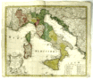 | Details | Homann Heirs | 1742 |
| Italia |
|
Homann Heirs |
|
| 1742 |
| LOC:58 |
| $490.00 | Homann-Heirs | Italia | Attractive antique map of Italy divided into provinces with the islands of Corsica ( Corse ), Sardinia ( Sardegna or Sardigna ), Sicily ( Sicilia ), Malta, Gozo, and Lampedusa. This large 18th century, hand-colored engraving was published from Nuremberg, Germany in 1742 (dated at top of map). Decorative title cartouche in Latin at bottom left of the map.
<br></br>
By the heirs of J. B. Homann. Homann Heirs (also "Homannianis Heredibus" or "Homann Erben" or "Heritiers de Homann") was a company established after the death of the famous German cartographer Johann Baptist Homann to carry on the publishing business of the firm he started in the early 1700's. The designation "Homann Heirs" appears on maps published by that successor firm from about 1730 to 1848. |
| 1040 |  | Details | Homann Heirs | 1743 |
| Carte d' Artois et des Environs |
|
Homann Heirs |
|
| 1743 |
| LOC:0 |
| $250.00 | Homann-Heirs | Carte-d--Artois-et-des-Environs | Decorative antique map of France covers the Duchy of Artois from Dunkerque to Abbeville and inland to Lille, Douai and Cambrai. Decorated with a very attractive uncolored title cartouche.
<br></br>
Published by the firm Homann Heirs. Homann Heirs (also "Homannianis Heredibus" or "Homann Erben" or "Heritiers de Homann") was a company established after the death of German cartographer J.B. Homann to carry on the publishing business of the firm he started in the early 1700's. The designation "Homann Heirs" appears on maps published by that successor firm from about 1730 to 1848. |
| 582 | 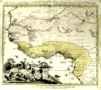 | Details | Homann Heirs | 1743 |
| Guinea propia |
|
Homann Heirs |
|
| 1743 |
| LOC:54 |
| $350.00 | Homann-Heirs | Guinea-propia | Decorative antique map of the West Coast of Africa from 1743 with several regions denoted by outline/wash coloring: Sahara, Ethiopia, Guinea. Map is marked with names of sub-regions, tribal kingdoms, and numerous notations in Latin. Large decorative cartouche at left of map focuses on the daily life of indigenous tribesmen and elephant tusks.
<br></br>
Published by the firm Homann Heirs. Homann Heirs (also "Homannianis Heredibus" or "Homann Erben" or "Heritiers de Homann") was a company established after the death of German cartographer J.B. Homann to carry on the publishing business of the firm he started in the early 1700's. The designation "Homann Heirs" appears on maps published by that successor firm from about 1730 to 1848. |
| 584 | 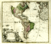 | Details | Homann Heirs | 1743 |
| Americae Mappa Generalis |
|
Homann Heirs |
|
| 1743 |
| LOC:52 |
| $500.00 | Homann-Heirs | Americae-Mappa-Generalis | Extremely decorative mid 18th-century antique map of North and South America by Homann.
<br></br>
Geographic coverage on this fine old relic includes Western Europe, West Africa, and large portions of both the Atlantic and Pacific Oceans. The territory in the U.S. Pacific Northwest was largely unexplored when the map was created and the area is shown as blank. At the time this map was printed knowledge of U.S. west coast geography had improved past the point in time when California was thought to be an island.
<br></br>
A highly decorative title cartouche at bottom left of this antique map features four native Americans and two erupting volcanos along with a large vessel containing coins.
<br></br>
Published by the firm Homann Heirs. Homann Heirs (also "Homannianis Heredibus" or "Homann Erben" or "Heritiers de Homann") was a company established after the death of German cartographer J.B. Homann to carry on the publishing business of the firm he started in the early 1700's. The designation "Homann Heirs" appears on maps published by that successor firm from about 1730 to 1848. |
| 3692 | 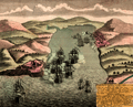 | Details | Homann Heirs | 1743 |
| Scarce antique view of Portobelo, Panama |
|
Homann Heirs |
|
| 1743 |
| LOC:77 |
| $225.00 | Homann-Heirs | Scarce-antique-view-of-Portobelo--Panama | Very scarce birds-eye view of Portobelo, Panama in Colon Province during its capture and destruction in 1739-1742 during the War of Jenkins' Ear. The map depicts the town of Portobelo, Fort Gloria, and the immediate vicinity, including the harbor and Fort Hierro (iron), constructed across the harbor from Portobelo. Several sailing ships depict a naval battle scene and notes in the title block identify and explain sixteen important locations and actions on the view.
<br></br>
Portobelo was founded in March 1597 as "San Felipe de Portobelo". A military compound, Portobelo belonged to a Spain's colonial defensive system, including Veracruz (Mexico), Cartagena (Colombia), and Havana (Cuba), to protect the route of commercial trade between the Americas and Spain. Portobelo, where the annual late summer trade fairs were held, was one of the principal Caribbean ports and played a leading role controlling Spain's imperial trade in the Americas.
<br></br>
Published by the firm Homann Heirs. Homann Heirs (also "Homannianis Heredibus" or "Homann Erben" or "Heritiers de Homann") was a company established after the death of German cartographer J.B. Homann to carry on the map publishing business of the firm he started in the early 1700's. The designation "Homann Heirs" appears on maps published by that successor firm from about 1730 to 1848. |
| 579 | 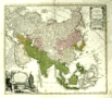 | Details | Homann Heirs | 1744 |
| Carte de l'Asie |
|
Homann Heirs |
|
| 1744 |
| LOC:59 |
| $355.00 | Homann-Heirs | Carte-de-l-Asie | Decorative antique map of Asia dated to 1744. Coverage include Egypt, Saudia Arabia, the Persian Gulf, India, China, Borneo, New Guinea, Siberia, and Japan, and the North Pole. Bottom left of this antique map contains a title cartouche with a large lizard, natives, and subtropical fauna.
<br></br>
Published by the firm Homann Heirs. Homann Heirs (also "Homannianis Heredibus" or "Homann Erben" or "Heritiers de Homann") was a company established after the death of German cartographer J.B. Homann to carry on the map publishing business of the firm he started in the early 1700's. The designation "Homann Heirs" appears on maps published by that successor firm from about 1730 to 1848.
<br></br> |
| 571 | 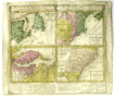 | Details | Homann Heirs | 1745 |
| Dominia Anglorum in America Septentrionali |
|
Homann Heirs |
|
| 1745 |
| LOC:53 |
| $495.00 | Homann-Heirs | Dominia-Anglorum-in-America-Septentrionali | Four early maps of the British colonies in North America on one page made 30+ years before the Revolutionary war, ca. 1745. These antique maps are based on the work of Herman Moll, a London-based cartographer and engraver.
<br></br>
Coverage on this antique copperplate engraving includes Newfoundland and Saint Lawrence Bay in Canada, New York, New England, New Jersey, Pennsylvania, the Carolina and Florida Territories, Virginia, and Maryland including Chesapeake Bay.
<br></br>
The four inset maps are titled as follows:<br>
A. Newfoundland od. Terra Nova S. Laurentii Bay die fisch-bank Acadia… New Schotland.<br>
B. New Engelland, New York, New Jersey, und Pensilvania.<br>
C. Virgina und Maryland<br>
D. Carolina ... Florida
<br></br>
Text below the maps elaborates on the maps, the Iroquis indians, and provides a brief dictionary of terms translated to German.
<br></br>
By the heirs of J. B. Homann. Homann Heirs (also "Homannianis Heredibus" or "Homann Erben" or "Heritiers de Homann") was a company established after the death of the famous German cartographer Johann Baptist Homann to carry on the map publishing business of the firm he started in the early 1700's. The designation "Homann Heirs" appears on maps published by that successor firm from about 1730 to 1848. |
| 569 | 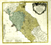 | Details | Homann Heirs | 1748 |
| Status Ecclesiastici Toscanae |
|
Homann Heirs |
|
| 1748 |
| LOC:66 |
| $290.00 | Homann-Heirs | Status-Ecclesiastici-Toscanae | Fine, large, hand-colored, copper-plate engraved antique map of Italy centered on Tuscany by the heirs of J. B. Homann. Includes Rome, Citavecchia, Ostia, Elba, Pisa, Ravenna, and the northern tip of Corsica. Leafy cartouche at top right decorated with the arms of Rome and Tuscany.
<br></br>
The map was published from Nuremberg, Germany in 1748 (dated at top).
<br></br>
Homann Heirs (also "Homannianis Heredibus" or "Homann Erben" or "Heritiers de Homann") was a company established after the death of the famous German cartographer Johann Baptist Homann to carry on the map publishing business of the firm he started in the early 1700's. The designation "Homann Heirs" appears on maps published by that successor firm from about 1730 to 1848. |
| 1073 |  | Details | Homann Heirs | 1756 |
| Plan of the town and port of Mahon on Minorca |
|
Homann Heirs |
|
| 1756 |
| LOC:58 |
| $1,050.00 | Homann-Heirs | Plan-of-the-town-and-port-of-Mahon-on-Minorca | Spectacular antique engraved port plan of the harbor, town, and defences of Mahon, the capital city of Menorca ( Minorca ) one of the Balearic Islands in the Mediterranean Sea, belonging to Spain. This attractive chart shows great detail of the interior of the island with delineation of hills, roads, streams and individual fields. Printed on 2 separate sheets each measuring approximately 18" x 18".
<br></br>
Britain captured and occupied Minorca beginning in 1708 until 1756 (year this chart was published) when France captured the island after the Siege of Fort St. Philip, led by the Duke de Richelieu, of France.
<br></br>
Two charts on separate sheets, not joined. Insets: Plan of Fort St. Philippe; cross-section of Fort St. Philippe.
<br></br>
Published in Nuremberg by Homann Heirs (also "Homannianis Heredibus" or "Homann Erben" or "Heritiers de Homann"), a company established after the death of German cartographer J.B. Homann to carry on the map publishing business of the firm he started in the early 1700's. The designation "Homann Heirs" appears on maps published by that successor firm from about 1730 to 1848. |
| 575 | 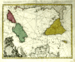 | Details | Homann Heirs | 1762 |
| Antique chart of the Mediterranean featuring Sicily Sardinia Corsica Malta Gozo |
|
Homann Heirs |
|
| 1762 |
| LOC:50 |
| $650.00 | Homann-Heirs | Antique-chart-of-the-Mediterranean-featuring-Sicily-Sardinia-Corsica-Malta-Gozo | Decorative antique chart of the southern boot of Italy with the islands of <strong>Corsica</strong> ( Corse ) , <strong>Sardinia</strong> ( Sardegna or Sardegna ), <strong>Sicily</strong> ( Sicilia ), <strong>Malta</strong>, <strong>Gozo</strong> and much more to the Gulf of Tunis and northern coast of Africa (Barbaria). Based on the work of Rizzi Zannoni. Dated in the top title to 1762. A highly decorative title cartouche at bottom left of this antique map contains angels carrying state coats of arms above symbols of war including a warship firing a salvo from its starboard side.
<br></br>
Published by the firm <strong>Homann Heirs</strong>. Homann Heirs (also "Homannianis Heredibus" or "Homann Erben" or "Heritiers de Homann") was a company established after the death of German cartographer J.B. Homann to carry on the map publishing business of the firm he started in the early 1700's. The designation "Homann Heirs" appears on maps published by that successor firm from about 1730 to 1848. |