| | Thumbnail | | Creator | Date | Title / Author / Date / Location | Price | | | Description |
| 806 | 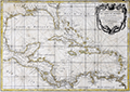 | Details | Rizzi Zannoni , Giovanni Antonio | 1762 |
| Gulf of Mexico and Caribbean Islands |
|
Rizzi Zannoni , Giovanni Antonio |
|
| 1762 |
| LOC:0 |
| $0.00 | Rizzi-Zannoni---Giovanni-Antonio | Gulf-of-Mexico-and-Caribbean-Islands | SOLD
<br></br>
Neat antique French map of the Gulf of Mexico, Southern United States, Mexico, Central America, Colombia and Venezuela with all the Caribbean islands described in French including Cuba, Porto Rico, St. Domingue, St. Croix, Antigua, la Martinique, la Barbade, and la Grenade. Florida is represented as an archipelago of islands, as was thought to be the case in the mid 18th century. Prominently marked habitations include Vera Cruz, Mexico; New Orleans, Louisiana; Pensacola, San Marcos ( Jacksonville ), and St. Augustine Florida; Port Royal, Jamaica; Cartagena, Colombia; and la Havane ( Havana ), Cuba.
<br></br>
Decorative 18th century cartouche with garland and a network of crossed rhumb lines gives this work a definitely nautical flavor. Engraved and published by Lattre from Rue St. Jacques, Paris. |