| | Thumbnail | | Creator | Date | Title / Author / Date / Location | Price | | | Description |
| 872 | 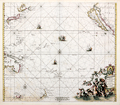 | Details | de Wit, Frederick | 1675 |
| Magnum Mare del Zur cum Insula California |
|
de Wit, Frederick |
|
| 1675 |
| LOC:0 |
| $3,100.00 | de-Wit--Frederick | Magnum-Mare-del-Zur-cum-Insula-California | This beautiful antique sea chart of the Pacific Ocean from 1675 is one of the earliest obtainable nautical charts of Oceana. The chart extends eastward from Japan, Korea and New Guinea to the newly explored west coast of North America with California shown as an island. The incomplete outline of landforms in Australasia reflect the limited exploration of that area.
<br></br>
This chart is the first and most desirable state, engraved by Frederick de Wit, with the imprint: "Gedruckt't Amsterdam by Frederick de Wit inde Calverstraet. " Published in de <b>Wit's Orbis Maritimus ofte Zee Atlas</b>, comprised of twenty-seven nautical charts of the world's oceans.
<br></br>
The concept that <b>Baja California was an island</b> rather than a peninsula dates back to the early 1500's. In 1701 Jesuit priest and cartographer Eusebio Francisco Kino published a map based on his explorations of the area showing Baja California to be a peninsula, but despite that work the question was not finally accepted by all cartographers until the mid-eighteenth century.
<br></br>
<b>Hollandia Nova</b>, or New Holland was the name given to the vast continent of Australia. On this early chart only the north coast of Australia and the Gulf of Carpentaria are depicted, with an incomplete outline of western New Guinea drawn above. Below, the outline of the southern half of Tasmania ( " Anthoni van Diemens Landt" ) and a portion of the east coast of New Zealand with the Cook Strait shown as a bay.
<br></br>
A very attractive decorative cartouche at bottom right features a portrait of Ferdinand Magellan gazing over a tableau of Poseidon and his consort Amphitrite riding a chariot through the sea while putti drape garland over the scene. Empty areas in the chart are filled with depictions of square-rigged warships under sail and firing cannon. Title is in Latin and Dutch. |
| 558 | 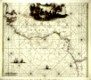 | Details | de Wit, Frederick | 1680 |
| Tractus Littorales Guineae |
|
de Wit, Frederick |
|
| 1680 |
| LOC:54 |
| $1,100.00 | de-Wit--Frederick | Tractus-Littorales-Guineae | Beautiful antique sea chart of north-west Africa. 1680. This chart was created by Frederick de Wit (1630-1706) a Dutch cartographer residing at the time in Amsterdam. A large cartouche at the top shows what is apparently a slave market with captive Africans bound kneeling as strange lizards roam the foreground.
<br></br>
The chart is decorated with images of sailing vesels and with numerous rhumb lines. Coverage extends from Cabo Blanco past cape Verde to the Congo River and beyond. |
| 969 | 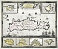 | Details | de Wit, Frederick | 1690 |
| Frederick de Wit's map of Crete with Heraklion, Chania and more |
|
de Wit, Frederick |
|
| 1690 |
| LOC:0 |
| $0.00 | de-Wit--Frederick | Frederick-de-Wit-s-map-of-Crete-with-Heraklion--Chania-and-more | SOLD
<br></br>
Highly decorative antique hand-colored map by de Wit of the island of Crete (Creta), Greece with six attractive insets plans showing the fortifications of Canea/ Chania, Candia / Heralkion, Spinalonga / Kalydon, Retimo/ Rethimnon, Thine / Tinos and Suda. The insets are after drawings of Sébastien Pontault de Beaulieu (1612-1674). Pontault, a French engineer, is considered to have been the inventor of the art of military topography.
</br></br>
For the insets of both Chania and Iraklio Wit has included a legend of key place names keyed alphabetically to locations on the plans. In the interior of this lovely map of Crete Wit includes mountains, rivers, villages, lakes, forts, and he records an extensive road network ranging widely across the island. Decorative elements include square-rigged ships, galleys, and putti carrying a sheet containing the title block.
</br></br>
At upper left are portions of the nearby islands of Kythera ("Cerigo") and Antikythera ("Cecerigo"). Fortifications of Spinalonga Island or Kalydon (just north of the Spinalonga Peninsula, near Elounda and Agio Nikolaos) are shown at bottom right. During the Venetian occupation of Crete Spinalonga Island was home to a fortress controlled by the Ventians until 1715.
</br></br>
From Amsterdam ca. 1690. Attribution reads: "by Frederick de Wit inde Kalverstraat inde Witte Paskaert".
Plate 23. Manuscript numeric "60" in top right corner. |