| | Thumbnail | | Creator | Date | Title / Author / Date / Location | Price | | | Description |
| 315 |  | Details | van Keulen, Gerard | 1698 |
| Nouvelle carte marine croissante en degres d'une partie des cotes maritime de Bretagne |
|
van Keulen, Gerard |
|
| 1698 |
| LOC:0 |
| $375.00 | van-Keulen--Gerard | Nouvelle-carte-marine-croissante-en-degres-d-une-partie-des-cotes-maritime-de-Bretagne | Antique nautical chart of Brittany (Bretagne) from 1698 by Gerard van Keulen, well known Dutch chart maker. Coverage is centered on the coastline, estuary and rivers near Morlaix, France. Goulven, St. Paul de Leon, and Lanion are among the largest towns depicted. Chart contains picturesque details that would have been useful to coastal navigators including villages, churches, windmills, offshore rocks and islands (Les Seit Isles; roche blanche) and navigational aids. Chart is set on a series of rhumb lines with two decorative compass roses. |
| 572 | 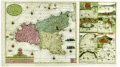 | Details | van Keulen, Gerard | 1724 |
| Sicilia |
|
van Keulen, Gerard |
|
| 1724 |
| LOC:0 |
| $4,000.00 | van-Keulen--Gerard | Sicilia | Extra-large, rare, original antique nautical chart of the island of Sicily, Italy. <strong>Two views of an erupting Mount Aetna ( Etna ) in Catania.</strong> Includes nine smaller harbor charts on the same sheet: Palermo, Trapani, Messina, Milazzo, Augusta, Catania, Agrigento and Siracusa. Unusually colorful and attractive specimen. Unusual to find this combination of large-scale and small-scale charts on a single page.
<br></br>
Inset at right in the sea shows two scenes related to the Battle of Cape Passaro, between Spanish and British naval forces on August 11, 1718 off the coast of Sicily. During the Battle of Cape Passaro, off the southeast coast of Sicily, forces led by British Admiral Sir George Byng aboard the flagship 'Barfleur' defeated Spanish naval forces led by Rear-Admiral Don Fernando Chacon.
<br></br>
By Gerard van Keulen, with the royal privilege, possibly from the third part of 'De Nieuwe Groote Lichtende Zee-Fakkel' published 1724. Near van Keulen's name is found the Coat of Arms of the Kingdom of Sicily with two facing eagles flanking the red stripes of the arms of the House of Aragon. |
| 544 | 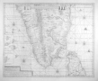 | Details | van Keulen, Gerard | 1728 |
| Nova Tabula Terrarum Cucan, Canara, Malabaria, Madura, Coromandelia |
|
van Keulen, Gerard |
|
| 1728 |
| LOC:0 |
| $0.00 | van-Keulen--Gerard | Nova-Tabula-Terrarum-Cucan--Canara--Malabaria--Madura--Coromandelia | SOLD<br></br>
Scarce Dutch chart of the Laccadive Islands, southern India, northern Sri Lanka (Ceylon) including the capital of Colombo. Based on the work of Adriaan Reland (Reelant) (1676-1718), a Dutch scholar and cartographer. The chart is decorated with numerous vignettes of sailing vessels and five compass roses.
<br></br>
Published by Gerard van Keulen in the fifth part of the sea-atlas "Zee-Fakkel" or Sea Torch which was issued by the House of Keulen in various editions from 1678 - 1753. According to C. Koeman this specific chart first appeared in the 1728 edition of the Zee-Fakkel. |
| 735 | 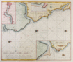 | Details | van Keulen, Gerard | 1730 |
| De Rivier Tyne Of New Castle |
|
van Keulen, Gerard |
|
| 1730 |
| LOC:64 |
| $575.00 | van-Keulen--Gerard | De-Rivier-Tyne-Of-New-Castle | Original detailed Dutch sea chart ca. 1730 of the north-east coast of England from Sunderland and the River Wear in the south to the River Blyth ( Blyt Haven ) in the north. Major geographic areas that Keulen identifies in this antique chart include: The Bishoprik of Durham, Nort ( Noord ) Humberland, and Schotland. With three detailed insets: of the Tyne river to Newcastle on Tyne; the mouth of the Tyne River; and the mouth of the Blyth River. Most place names are in Dutch and some also include their English equivalent. Numerous soundings, aids to navigation, rocks, sandbanks and other hazards along with 4 compass roses and numerous rhumb lines attest to the nautical nature of this working nautical chart.
<br></br>
By Gerard van Keulen (1678–1726), son of Johannes van Keulen (d 1715), founder of the Dutch publishing house that produced "the largest and finest marine atlases in Holland". Gerard possessed mathematical, scientific, and engraving skills that enabled him to build the firm started by his father into a substantial and respected business venture. (C. Koeman. "The Sea on Paper: The Story of the Van Keulens and their 'Sea Torch'."Theatrum Orbis Terrarum Ltd. Amsterdam, 1972). |
| 741 | 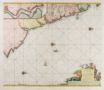 | Details | van Keulen, Gerard | 1730 |
| Antique Chart of northeast England near Newcastle and Tyne River |
|
van Keulen, Gerard |
|
| 1730 |
| LOC:64 |
| $550.00 | van-Keulen--Gerard | Antique-Chart-of-northeast-England-near-Newcastle-and-Tyne-River | Antique Dutch nautical chart depicting the Yorkshire coast of England and Scotland's east coast south of Edinburgh. Contains a detailed inset showing the river Tyne and Newcastle at top left. Coverage of coastal habitations and geographical features includes: Flamborough Head, Filey Bay, Stockton-on-Tees, Newcastle, Hartlepool, Sunderland, the Tyne River, Morpeth, North Berwick, and the entrance to the Firth of Forth ("de Rivier van Edenborg").
<br></br>
Very decorative title cartouche in Dutch depicts a mermaid and mermen with fishes. The blank area in the North Sea is decorated with a sea serpent, three colorful compass roses, and a square-rigged sailing vessel. North is oriented to the right. Plate 23.
<br></br>
Gerard van Keulen (1678–1726) was the son of Johannes van Keulen (d. 1715), founder of the Dutch publishing house that produced "the largest and finest marine atlases in Holland". Gerard possessed mathematical, scientific, and engraving skills that enabled him to build the firm started by his father into a substantial and respected business venture. (C. Koeman. "The Sea on Paper: The Story of the Van Keulens and their 'Sea Torch'."Theatrum Orbis Terrarum Ltd. Amsterdam, 1972). |
| 740 | 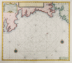 | Details | van Keulen, Gerard | 1730 |
| Antique Nautical Chart of South Cornwall Including Plymouth |
|
van Keulen, Gerard |
|
| 1730 |
| LOC:64 |
| $525.00 | van-Keulen--Gerard | Antique-Nautical-Chart-of-South-Cornwall-Including-Plymouth | Antique Dutch nautical chart of a portion of South Cornwall, England coastline extending from Falmouth in the southwest past Plymouth Sound as far east as Bigbury-on-the Sea. Noted features include Pendennis Castle, St. Mawes Castle, Fay Castle, Palmere, Fovey, Rame Head, Trematon Castle, Eddystone Light, and the Citadel at Plymouth. Published ca. 1730 from Amsterdam by Gerard van Keulen with a title cartouche written in English, and Dutch.
<br></br>
Gerard van Keulen (1678–1726) was the son of Johannes van Keulen (d. 1715), founder of the Dutch publishing house that produced "the largest and finest marine atlases in Holland". Gerard possessed mathematical, scientific, and engraving skills that enabled him to build the firm started by his father into a substantial and respected business venture. (C. Koeman. "The Sea on Paper: The Story of the Van Keulens and their 'Sea Torch'."Theatrum Orbis Terrarum Ltd. Amsterdam, 1972). |
| 736 | 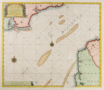 | Details | van Keulen, Gerard | 1730 |
| Dutch chart of the English Channel from Calais to Dover |
|
van Keulen, Gerard |
|
| 1730 |
| LOC:64 |
| $0.00 | van-Keulen--Gerard | Dutch-chart-of-the-English-Channel-from-Calais-to-Dover | SOLD <br></br>
Original antique Dutch nautical chart ca. 1730 of the English Channel by Gerard van Keulen with a title cartouche written in English, French, and Dutch. On the English side of the Channel in Kent the shoreline extends from Rye and Socket with the Rye Camber past Hyth, Sandgate Castle, Dover and Dover Castle, ending at the South Foreland. Just east of the mouth of the Rye is shown a lighthouse on a large sandbar- the Dungeness ( Dungines of Singel ) . This is probably the structure known as 'Lamplough's Tower' originally constructed in 1635 that would have still been standing 100 years later.
<br></br>
Across the Channel the coast of France is shown from Dannes to Pointe d' Alpree, Boulogne, Fort d'Ordre, Ambleteuse, Wissant ( Wisam ) Cap Grines, Cap Blanet, and ends at Calais ( Cales ), France. Features noted on the chart include the Forest d' Mardelot, La Liane, Moulin de Ramseau, Moulin de Coquelle, and Fort Nieulay.
<br></br>
By Gerard van Keulen (1678–1726), son of Johannes van Keulen (d 1715), founder of the Dutch publishing house that produced "the largest and finest marine atlases in Holland". Gerard possessed mathematical, scientific, and engraving skills that enabled him to build the firm started by his father into a substantial and respected business venture. (C. Koeman. "The Sea on Paper: The Story of the Van Keulens and their 'Sea Torch'."Theatrum Orbis Terrarum Ltd. Amsterdam, 1972). |
| 1448 | 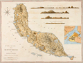 | Details | van Keulen, Gerard | 1775 |
| Curacao by Gerard van Keulen West-India Atlas Jefferys Sayer |
|
van Keulen, Gerard |
|
| 1775 |
| LOC:51 |
| $1,800.00 | van-Keulen--Gerard | Curacao-by-Gerard-van-Keulen-West-India-Atlas-Jefferys-Sayer | Fine, very desirable chart of Curaçao in the Lesser Antilles of the Caribbean Sea. Inset plan of Fort Amsterdam, in Willemstad, constructed in 1634 by the Dutch West India Company. A beautiful British published chart based on hydrographic surveys by Dutch cartographer Gerard van Keulen.
<br></br>
The chart is from the scarce <b>first issue of 1775 by Sayer</b>, the other issues being 1781, 1787, 1794, 1796, 1807, and 1818 published by Sayer and then Laurie and Whittle. <a href="https://www.davidrumsey.com/home" target="_blank">(Online).</a>
<br></br>
From: "The West-India Atlas: or, A Compendious Description of the West-Indies: illustrated with Forty Correct Charts and Maps, taken from Actual Surveys. Together with An Historical Account of the Several Countries and Islands which compose that part of the world. Their Discovery, Situation, Extent, Boundaries, Product, Trade, Inhabitants, Strength, Government, Religion, &c."
Authors: Gerard van Keulen, Thomas Jefferys.
Publishers: Robert Sayer.
Jefferys died in 1771; Sayer acquired Jefferys' materials in preparation for this atlas, and published the atlas posthumously under his name. |
| 1450 | 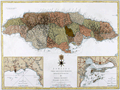 | Details | van Keulen, Gerard | 1775 |
| Jefferys Sayers Chart of Jamaica from West-India Atlas |
|
van Keulen, Gerard |
|
| 1775 |
| LOC:51 |
| $450.00 | van-Keulen--Gerard | Jefferys-Sayers-Chart-of-Jamaica-from-West-India-Atlas | Attractive, very desirable antique British chart of the Island of Jamaica in the Caribbean Sea by Thomas Jefferys. After surveys by Dutch cartographer Gerard Van Keulen.
<br></br>
This spectacular chart is from the scarce <b>first issue of The West-India Atlas, 1775 by Sayer</b>, the other issues being 1781, 1787, 1794, 1796, 1807, and 1818 published by Sayer and then Laurie and Whittle. <a href="https://www.davidrumsey.com/home" target="_blank">(Online).</a>
<br></br>
"The West-India Atlas: or, A Compendious Description of the West-Indies: illustrated with Forty Correct Charts and Maps, taken from Actual Surveys. Together with An Historical Account of the Several Countries and Islands which compose that part of the world. Their Discovery, Situation, Extent, Boundaries, Product, Trade, Inhabitants, Strength, Government, Religion, &c."
Authors: Gerard van Keulen, Thomas Jefferys.
Publishers: Robert Sayer.
Jefferys died in 1771; Sayer acquired Jefferys' materials in preparation for this atlas, and published the atlas posthumously under his name. |