| | Thumbnail | | Creator | Date | Title / Author / Date / Location | Price | | | Description |
| 760 | 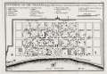 | Details | Bellin, Jacques Nicolas | 1744 |
| Plan of New Orleans French Quarter German ed. |
|
Bellin, Jacques Nicolas |
|
| 1744 |
| LOC:3 |
| $0.00 | Bellin--Jacques-Nicolas | Plan-of-New-Orleans-French-Quarter-German-ed- | SOLD<BR> </BR>
German edition of J.N. Bellin's well-known plan of the city of New Orleans, based on a manuscript document created approximately 15 years after the city was founded along high ground on the east bank of the Mississippi river. This plan from New Orlean's French colonial period, shows the city neatly laid out with streets most residents would recognize today as the French Quarter.
<BR> </BR>
The plan is based on a design initially created by military engineers Adrien de Pauger and Le Blond de la Tour in 1722. That plan envisioned a street grid extending six blocks northward from the Mississippi River, a plan that was likely scaled back in 1729 as a result of the Natchez Indian massacre of settlers at Fort Rosalie near Natchez Mississippi. At that point security became paramount. This plan by Bellin is more similar to an unsigned manuscript plan of New Orleans from 1732, which showed the city extending only 4 blocks north from the river, and partially surrounded by a defensive moat. The new emphasis on security, when the population totaled less than 2000 persons, is reflected in some of the other features found in Bellin's plan: guardhouses, a powder magazine, and a single bridge controlling access across the moat to the city. Those features were absent in Pauger's plan.
<br></br>
This plan was probably published in a German edition of Charlevoix's 'History and General Description of New France' which was originally published in French from Paris during 1744. (Source: Lemmon, Alfred E., John T Magill, and Jason R. Wiese. Charting Louisiana. The Historic New Orleans Collection. 2003).
<br></br><hr>
<a style="color:#0000EE" rel="nofollow" href= "https://www.rarecharts.com/ShowDetail/Creator/Tirion--Isaac/Title/Maps-of-French-Colonial-New-Orleans-and-the-Mississippi-River/1069">View this similar, larger map by Isaac Tirion from 1769.<br><br/>
<img src="http://www.rarecharts.com/ZoomifyImages/SC_1069/TN.gif"/> </a><BR> </BR><hr> |
| 1057 | 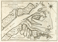 | Details | Bellin, Jacques Nicolas | 1744 |
| Antique chart of the mouth of the Mississippi River |
|
Bellin, Jacques Nicolas |
|
| 1744 |
| LOC:3 |
| $0.00 | Bellin--Jacques-Nicolas | Antique-chart-of-the-mouth-of-the-Mississippi-River | SOLD</br><br>One of the earliest available charts to focus solely on the passes at the mouth of the Mississippi River, then considered by the French to be their overseas possession. The location covered by this chart lies roughly 75 miles southeast of New Orleans, Louisiana which had only been founded in 1718 by the French Mississippi Company, under the leadership of Jean-Baptiste Le Moyne de Bienville.
<br></br>
This is the first and earliest of two small charts by the Depot de la Marine; the later chart appeared in Bellin's 1764 "Le Petit Atlas Maritime". This chart is characterized by numerous descriptions of the hydrography ("recif" or reef; "bancs de vase molle" or soft mudflats; and "le bare") but contains no depth soundings. The southwest pass is particularly interesting for it is labeled "Embouchure par ou les vaisseau entrant" or mouth where vessels enter. Just inside the mouth near two reefs a small ship is depicted aground ("V[aisse]au Echoué"). Further up the channel ("Chenal") is Fort de la Balise (Fr. seamark). At that spot the French constructed a 62 foot high pyramidal wooden tower (the Balise) in 1721.
<br></br>
This chart was undoubtedly based on observations prior to 1740 when the Balise was destroyed by a hurricance. Bellin's later 1764 chart shows no structure at that location, just a mass of debris. |
| 4694 | 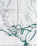 | Details | Anville, Jean Baptiste Bourguignon d' | 1752 |
| Carte De La Louisiane |
|
Anville, Jean Baptiste Bourguignon d' |
|
| 1752 |
| LOC:53 |
| $1,250.00 | Anville--Jean-Baptiste-Bourguignon-d- | Carte-De-La-Louisiane | Large, scarce antique map by d'Anville of the lower Mississippi, the Arkansas, the Red, the Osage, and lower Missouri rivers as well as much of the coast bordering on the Gulf of Mexico. States included in this copperplate-engraved French antique map are Texas, Louisiana, Mississippi, Alabama and Florida.
<br></br>
Large inset map of the Mississippi River system including the Illinois and Missouri Rivers with several French forts. Identifies locations of numerous native American Indian settlements including the Metchigamias, Caskakias, Osage, Kansez, Tapouchas, Chacchoumas, and Petits Akansas. The town of St. Louis, Missouri, not founded until 1763, is not shown but two references to the Cahokia Indians including an "Ancien Village des Caho." are identified.
<br></br>
This two-sheet map is sometimes found in separate sheets but here both sheets are joined together resulting in a large 37" wide image.
<br></br>
Points of interest include New Orleans, Pascagoula, Mobile, and Pensacola Bay (Baye de Ste. Marie de Galbes), and St. Josephs Bay. |
| 1415 | 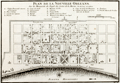 | Details | Bellin, Jacques Nicolas | 1753 |
| Antique Colonial-era Plan of the French Quarter in New Orleans, Louisiana |
|
Bellin, Jacques Nicolas |
|
| 1753 |
| LOC:3 |
| $600.00 | Bellin--Jacques-Nicolas | Antique-Colonial-era-Plan-of-the-French-Quarter-in-New-Orleans--Louisiana | Antique French plan of the city of New Orleans, Louisiana ("la Nouvelle Orleans") from the period of French colonization ca. 1753. This antique city plan of New Orleans by Nicolas Bellin was based on a manuscript map created by Pauger approximately 15 years after the city was founded on the east bank of the Mississippi river.
<BR> </BR>
Bellin's plan shows the city laid out with French Quarter streets most residents would recognize today including Bienville, Bourbon, Chartres, Royale and at the center of the plan- Jackson Square. Note the spelling of the Mississippi River below the town with one "P" as "Fleuve Mississipi".
<BR> </BR>
On this old uncolored, copper-plate engraved map nineteen key points within the city are keyed to a legend on the map just below the title. These important locations within early New Orleans include:
<div class="indenttextblock">
<ul style="list-style-type: circle;">
<li>Prisons</li>
<li>Place d'Armes (today's Jackson Square)</li>
<li> l'Eglise Paroissiale (parish church)</li>
<li>Poudriere (powder magazine)</li>
<li>Magasins du Roi (Royal stores)</li>
<li>Nouvelle Maison du Urselines (or new home for the Ursuline nuns, an important force in early New Orleans)</li>
<li>Forges du Roi (the King's forge or metalworking shop)</li>
<li>Moulin a vent et a Cheval (a mill operated by the wind and horse )</li>
</ul>
</div>
The plan is based on a design initially created by military engineers Adrien de Pauger and Le Blond de la Tour in 1722. That plan envisoned a street grid extending six blocks northward from the Mississippi River, a plan that was likely scaled back in 1729 as a result of the Natchez Indian massacre of settlers at Fort Rosalie near Natchez Mississippi. At that point security became paramount, reflected in some of the other features found in Bellin's plan: guardhouses, a powder magazine, and a single bridge controlling access across the moat to the city. Plate number 19. |
| 1193 | 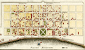 | Details | Bellin, Jacques Nicolas | 1753 |
| Plan de la Nouvelle Orleans (3) |
|
Bellin, Jacques Nicolas |
|
| 1753 |
| LOC:3 |
| $700.00 | Bellin--Jacques-Nicolas | Plan-de-la-Nouvelle-Orleans-(3) | Antique French plan of the city of New Orleans, Louisiana ("la Nouvelle Orleans") from the period of French colonization ca. 1753. This antique city plan of New Orleans was based on a manuscript map created approximately 25 years after the city was founded on the east bank of the Mississippi river. This neat hand-colored, copper-plate engraved map shows the city laid out with French Quarter streets most residents would recognize today including Bienville, Bourbon, Chartres, Royale and at the center of the plan- Jackson Square. Note the spelling of Mississippi below the town with one "P" as "Fleuve Mississipi".
<BR> </BR>
Nineteen key points within the city are keyed to a legend on the map just below the title. These key points within early New Orleans include:
<div class="indenttextblock">
<ul style="list-style-type: circle;">
<li>Prisons</li>
<li>Place d'Armes (today's Jackson Square)</li>
<li> l'Eglise Paroissiale (parish church)</li>
<li>Poudriere (powder magazine)</li>
<li>Magasins du Roi (Royal stores)</li>
<li>Nouvelle Maison du Urselines (or new home for the Ursuline nuns, an important force in early New Orleans)</li>
<li>Forges du Roi (the King's forge or metalworking shop)</li>
<li>Moulin a vent et a Cheval (a mill operated by the wind and horse )</li>
</ul>
</div>
Interestingly, what appears to be a defensive wall around the city is labeled "fosse' plein d'eau". Fosse' is French for "canal". Therefore, even at this relatively early point in its history New Orleans, Louisiana had a canal originating in the vicinity of today's Canal Street. An opening for a gate labeled "St. Jean" would have allowed access to a road leading to Bayou St. John, then an important route to points East. Plate number 19. |
| 99 | 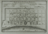 | Details | Bellin, Jacques Nicolas | 1753 |
| Plan de la Nouvelle Orleans - SOLD |
|
Bellin, Jacques Nicolas |
|
| 1753 |
| LOC:0 |
| $0.00 | Bellin--Jacques-Nicolas | Plan-de-la-Nouvelle-Orleans---SOLD | <BR></BR>
This plate has been SOLD but please see another <a style="color:#0000EE" rel="nofollow" href="https://www.rarecharts.com/ShowDetail/Creator/Bellin--Jacques-Nicolas/Title/Plan-de-la-Nouvelle-Orleans-(3)/1193">hand-colored engraving of Bellin's plan.</a>
<br><br/>
Bellin's famous plan of the city of New Orleans, based on a manuscript map created approximately 25 years after the city was founded along high ground on the east bank of the Mississippi river. Shows the city neatly laid out with streets most residents would recognize today including Bourbon, Chartres, Royale and at the center of the plan- Jackson Square. Number 19.<BR> </BR>
Interestingly, what appears to be a defensive wall around the city is labeled "fosse' plein d'eau". Fosse' is French for "canal". Therefore, even at this relatively early point in its history New Orleans had a canal originating in the vicinity of today's Canal Street. |
| 591 | 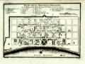 | Details | Bellin, Jacques Nicolas | 1753 |
| Plan de la Nouvelle Orleans |
|
Bellin, Jacques Nicolas |
|
| 1753 |
| LOC:0 |
| $0.00 | Bellin--Jacques-Nicolas | Plan-de-la-Nouvelle-Orleans | <BR></BR>
This plate has been SOLD but please see another <a style="color:#0000EE" rel="nofollow" href="https://www.rarecharts.com/ShowDetail/Creator/Bellin--Jacques-Nicolas/Title/Plan-de-la-Nouvelle-Orleans-(3)/1193">hand-colored engraving of Bellin's plan.</a>
<br><br/>
J.N. Bellin's early plan of the city of New Orleans, Louisiana. |
| 378 | 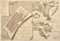 | Details | Jefferys, Thomas | 1759 |
| Plan of New Orleans and the Mississippi River |
|
Jefferys, Thomas |
|
| 1759 |
| LOC:0 |
| $0.00 | Jefferys--Thomas | Plan-of-New-Orleans-and-the-Mississippi-River | SOLD
<BR></BR>
Large, early foundational map for the collector of New Orleans cartography. By English cartographer Thomas Jefferys. Stunning and quite scarce plan of New Orleans, Louisiana with insets of the mouth of the Mississippi River and also a long stretch of the river from south of Donaldsonville to the passes. The map of New Orleans's French Quarter is similar to the earlier chart by <a rel="nofollow" href = "http://www.rarecharts.com/creator/Bellin--Jacques-Nicolas/" > Jacques Bellin</a> but contains additional details outside the French Quarter, which was largely marsh land at that time, including a road to Bayou St. John.<BR> </BR>
See <a rel="nofollow" href= "https://www.rarecharts.com/displaybycategory/city/new%20orleans"> other New Orleans items.</a> <BR> </BR>
Attribution and date at bottom: "Nov 1759. Published According to Act of Parliament by T. Jefferys at Charing Cross Price 2d.<BR> </BR> |
| 1111 | 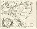 | Details | London Magazine | 1761 |
| A New Map of Louisiana and the River Mississipi from the Sea to Bayagoulas |
|
London Magazine |
|
| 1761 |
| LOC:0 |
| $0.00 | London-Magazine | A-New-Map-of-Louisiana-and-the-River-Mississipi--from-the-Sea-to-Bayagoulas | SOLD<br></br>Detailed antique map of the Mississippi River Delta taken from Thomas Jefferys' larger three-part map of the vicinity of New Orleans. Captures a point in time before subsidence and the rising sea level caused the loss of many hundred thousand acres of Louisiana land to the sea.
<br></br>
Bayou Lafourche is named "Cheimachas River" ; in contemporaneous French documents the waterway, once a distributary stream of the Mississippi River, was called "Bayou Lafourche des Chitimachas" after the Chitimacha Indians who inhabited land near present day Donaldsonville. The map shows the course of the Mississippi from Bayagoulas near the present-day town of Bayou Goula in Iberville Parish, Louisiana to Fort la Balise, which defended the entrance and channel of the river.
<br></br>
Contains very intersting notations including "Forest of Holms Fit for Ship Building" ("holm" refers to evergreen oak trees- probably the southern live oak ) and "Tchaouachas where Marshall de Bellisle had his grant". The latter notation near upper Plaquemine Parish refers to François Simars de Bellisle, first an officer of the French West Indies Company who wandered south-east Texas and Louisiana as a indian captive and slave from 1719 - 1721. In 1753 de Bellisle became a member of the Superior Council of Louisiana and served as town commander of New Orleans.
<br></br>
An important feature of this map is the depiction of the ruins of Fort La Boulaye the First Settlement made in 1700. This fort, located on the eastern bank of the Mississippi River about fifty miles from the Gulf of Mexico, was established by Pierre Le Moyne d'Iberville in 1700 and was abandoned about seven years later. In 1933 the remains of Fort La Boulaye were discovered near present-day Phoenix, Louisiana, in Plaquemines Parish. |
| 3640 | 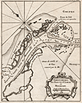 | Details | Bellin, Jacques Nicolas | 1763 |
| Scarce mid eighteenth-century antique map of the Mississippi River passes. |
|
Bellin, Jacques Nicolas |
|
| 1763 |
| LOC:77 |
| $400.00 | Bellin--Jacques-Nicolas | Scarce-mid-eighteenth-century-antique-map-of-the-Mississippi-River-passes- | Very attractive early French maritime map shows the mouth of the "Fleuve St. Louis" or Mississippi River in Louisiana. Noted locations include Passe a la Loutre and Isle de la Fort de Balise.
<br></br>
From J.N. Bellin's <b>Le Petit Atlas Maritime</b> . With soundings at the key passes into the Gulf of Mexico. Lacks latitude and longitude scales. North is oriented to the top left of map. Tome I, No. 38. |
| 1069 | 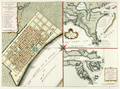 | Details | Tirion, Isaac | 1769 |
| Maps of French Colonial New Orleans and the Mississippi River |
|
Tirion, Isaac |
|
| 1769 |
| LOC:10 |
| $1,175.00 | Tirion--Isaac | Maps-of-French-Colonial-New-Orleans-and-the-Mississippi-River | Scarce early plan of New Orleans, Louisiana with insets of the mouth of the Mississippi River and also a long stretch of the Mississippi river from south of Donaldsonville to the passes. Published less than 50 years after the founding of New Orleans, Tirion's map of New Orlean's French Quarter is derived from an earlier map by Jacques Bellin / Brion de la Tour but contains additional details outside the French Quarter, which was largely marsh land at that time, including a road to Bayou St. John, a key trade route to the city from the east.
<br></br>
The sheet with three views is based on the layout of Thomas Jefferys earlier work (1759), who borrowed the earlier works of Jacques Bellin, of France's Depot de la Marine. Text is in German.
<br></br>
Isaak Tirion, (1705 - 1765) was a Dutch publisher who produced serveral atlases and Dutch town plans from the Kalverstraat, in Amsterdam. Tirion produced eight atlases in multiple editions |
| 449 | 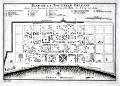 | Details | Bellin, Jacques Nicolas | 1774 |
| Plan de la Nouvelle Orleans (2) |
|
Bellin, Jacques Nicolas |
|
| 1774 |
| LOC:0 |
| $0.00 | Bellin--Jacques-Nicolas | Plan-de-la-Nouvelle-Orleans-(2) | <BR></BR>
This plate has been SOLD but please see another <a style="color:#0000EE" rel="nofollow" href="https://www.rarecharts.com/ShowDetail/Creator/Bellin--Jacques-Nicolas/Title/Plan-de-la-Nouvelle-Orleans-(3)/1193">hand-colored engraving of Bellin's plan.</a>
<br><br/>
A very desirable map and one of the few maps available from the colonial period, Nicolas Bellin's famous plan of the city of New Orleans, Louisiana is based on a manuscript map created approximately 15 years after the city was founded along high ground on the east bank of the Mississippi river. The plan depicts the city neatly laid out with streets most residents would recognize today including Bourbon, Chartres, Royale and at the center of the plan- Jackson Square.
<BR> </BR>
Copies of this map are increasingly difficult to find and prices have increased substantially since Hurricane Katrina. From "Histoire Generale des Voyages ou Nouvelle Collection de Toutes Relations de Voyages par Mer et par Terre". Published by van Harrevelt and Changuion; Amsterdam. Volume 21.
<BR> </BR>
The plan is based on a design initially created by military engineers Adrien de Pauger and Le Blond de la Tour in 1722. That plan envisioned a street grid extending six blocks northward from the Mississippi River, a plan that was likely scaled back in 1729 as a result of the Natchez Indian massacre of settlers at Fort Rosalie near Natchez Mississippi. At that point security became paramount. This plan by Bellin is more similar to an unsigned manuscript plan of New Orleans from 1732, which showed the city extending only 4 blocks north from the river, and partially surrounded by a defensive moat. The new emphasis on security, when the population totaled less than 2000 persons, is reflected in some of the other features found in Bellin's plan: guardhouses, a powder magazine, and a single bridge controlling access across the moat to the city. Those features were absent in Pauger's plan. |
| 3591 | 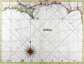 | Details | Jefferys, Thomas | 1775 |
| Antique Chart of Coast of West Florida and Louisiana |
|
Jefferys, Thomas |
|
| 1775 |
| LOC:51 |
| $0.00 | Jefferys--Thomas | Antique-Chart-of-Coast-of-West-Florida-and-Louisiana | SOLD<br><br>
Fine antique nautical chart and an important chart for the collector of Gulf Coast history. Geographic coverage on this antique chart extends from Sabine Pass, Texas (Cabo del Norte ) to Apalachicola Bay in the Florida Territory.
<br></br>
This first-edition British copper-engraved navigational chart documents the lack of knowledge about Chandeleur Sound (1775) where a note about the waters inside those barrier islands states "Shallow water with many small islands but very little known". In the later second state (not shown) the depiction of the sound is updated with greater detail (Breton Island, Grand osier Island) and the placename "Bay of Spiritu Santu" fills in what we now call Chandeleur Sound. Bayou Lafourche is labeled "Chetimachas River" after the Chitimacha Indians who were known to inhabit the area near Donaldsonville, La. Barataria Bay is labeled "Lake Ouachas".
<br></br>
A decorative flotilla graces the middle of our chart, highlighting a dashed line from west to southeast. That dotted line, Jeffery noted was, "The Flota's Track from la Vera Cruz [Mexico] to Havanna to avoid the Trade Winds".
<br></br>
Very attractive decorative compass rose.
<br></br>
From Sayer's and Bennett's atlas titled: "The West-India Atlas: or, a compendious description of the West-Indies: illustrated with forty one correct charts and maps, taken from actual surveys."
<br></br>
Publishers attribution reads: "London. Printed for Rob.t Sayer, Map and Printseller. No 53 Fleet Street as the Act directs 20th Feb.y 1775. According to Rumsey <div class="indenttextblock">
"Sayer and Bennet acquired his [Jefferys'] materials in preparation for this atlas, and published the atlas posthumously under his name (as they did with the American Atlas) in 1775. (
<a href="http://www.davidrumsey.com/luna/servlet/detail/RUMSEY~8~1~2795~310044:The-coast-of-Yucatan-from-Campeche-" target="_blank">Internet </a>)
</div> |
| 964 | 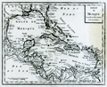 | Details | Anonymous | 1800 |
| Antique map of the Gulf of Mexico and Caribbean Sea |
|
Anonymous |
|
| 1800 |
| LOC:0 |
| $0.00 | Anonymous | Antique-map-of-the-Gulf-of-Mexico-and-Caribbean-Sea | SOLD <br></br>
Antique copper-plate engraved map of the Caribbean, <b>Gulf of Mexico</b>, Central America and portions of Colombia and Venezuela. This original old map ca. 1800 shows Florida as an archipelago of islands as well as the key cities of Havana, Cuba; Saint Augustine and Pensacola, Florida; Mobile, Alabama; <b>New Orleans, Louisiana</b>; and Port-Royal, Jamaica. Because the wide area encompassing the Louisiana Purchase is labeled as "Louisiana" we can date the map to prior to 1803, the date of that transaction.
<br></br>
After a map produced by J.B. Nolin for his "<i>Atlas Général a l'usage des colleges et maisons d'education</i>". Plate 25, |
| 2576 | 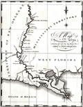 | Details | Schultz, Christian | 1810 |
| Early Original Map of the Mississippi River from Ohio R. to Gulf of Mexico |
|
Schultz, Christian |
|
| 1810 |
| LOC:10 |
| $0.00 | Schultz--Christian | Early-Original-Map-of-the-Mississippi-River-from-Ohio-R--to-Gulf-of-Mexico | SOLD
<br></br>
Finely executed original antique map of the <b>Mississippi River</b> from <b>Fort Jefferson, Kentucky</b>, near the junction with the Ohio River, to the Gulf of Mexico. Fort Jefferson was established in 1780 by George Rogers Clark at the express instruction of the then Governor of Virginia, Thomas Jefferson. The fort was abandoned in June 1781.
<br></br>
The area bounded by Bayou Manchac, Lake Ponchartrain and the Mississippi River is labeled "Island of New Orleans". In 1803 Alexander Hamilton wrote <div class="indenttextblock">"The Island of New-Orleans is in length about 150 miles; its breadth varies from 10 to 30 miles. Most of it is a marshy swamp, periodically inundated by the river. The town of New-Orleans, situated about 105 miles from the mouth of the river, contains near 1300 houses, and about 8000 inhabitants, chiefly Spanish and French. It is defended from the overflowings of the river, by an embankment, or leveé, which extends near 50 miles."(Purchase of Louisiana, [5 July 1803],” Founders Online, National Archives, last modified June 13, 2018, http://founders.archives.gov/documents/Hamilton/01-26-02-0001-0101.) </div>
<br></br>
This fine antique copper-plate engraved map is is one of the earliest maps of the Mississippi River published in America. Drawn by Christian Schultz. Two maps on one sheet.
<br></br>
Published in 1810 for Christian Schultz's "Travels on an Inland Voyage Through the States of New York, Pennsylvania, Virginia, Ohio, Kentucky and Tennessee, and through the territories of Indiana, Louisiana, Mississippi, and New-Orleans; performed in the years 1807 and 1808…"
<br></br>
Schultz's work is one of the earliest works to give a detailed account of travel and the actual risks and dangers encountered in the western country. Schultz's book is a compilation of his letters, and was published in direct response to the negative reports in an earlier travel guide written by Englishman Thomas Ashe in 1806. |
| 6721 |  | Details | Yeager, Joseph | 1817 |
| Battle of New Orleans Engraving Death Packenham |
|
Yeager, Joseph |
|
| 1817 |
| LOC:86 |
| $1,200.00 | Yeager--Joseph | Battle-of-New-Orleans-Engraving-Death-Packenham | This engraved copper-plate print, created in 1817 by Joseph Yeager after William Edward West, depicts the decisive moment in American history when Major General Andrew Jackson led United States forces to a victory over the British Army and Royal Navy near Chalmette, Louisiana in the Battle of New Orleans. This significant triumph marked a turning point in the War of 1812.
<br><br>
The print vividly portrays the intensity and drama of the battle, capturing the heroic victory of the American soldiers over the invading British forces. General Edward Pakenham's death signified the end of the battle.
<br><br>
The print shows the British forces as they advance upon the American earthworks or barricades, which were fiercely defended by Jackson's forces. At the bottom center, a head-and-shoulders portrait of Andrew Jackson, along with American flags and weapons.
<br><br>
Second state issue of the print includes thirteen lettered keys lacking in the first, and also features the figure of Gen. Lambert pointing to the right. In the first state, Lambert is depicted weeping into a handkerchief.
<br><br>
Copper engraving. Printed by Yerkes Saurman (1791- )
<br><br> |
| 1178 | 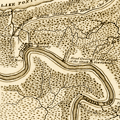 | Details | Melish, John | 1822 |
| 1822 Antique map of the New Orleans, Louisiana vicinity |
|
Melish, John |
|
| 1822 |
| LOC:3 |
| $325.00 | Melish--John | 1822-Antique-map-of-the-New-Orleans--Louisiana-vicinity | Scarce (1822) copperplate engraved map of New Orleans by John Melish. Map is uncommon. Coverage includes Bayou St. John, the lower shore of Lake Ponchartrain and a stretch of the Mississippi river below New Orleans. Legend at bottom graphically identifies two types of swamp surrounding New Orleans: "Cypress Swamp" and "Prairie Swamp".
<br></br>
Melish's named features include:
<div class="indenttextblock">
<ul style="list-style-type: circle;">
<li>Fort St. John</li>
<li>Borough of St. John</li>
<li>Suburb of Marigny</li>
<li>Bayou Sauvage and the Road to Chef Menteur</li>
<li>English Turn</li>
<li>Woodsville</li>
<li>Lake Lery</li>
<li>The Ouatchas River</li>
</ul>
</div>
Contains several notes related to the Battle of 1812 with the landing site and route of British forces identified.
<br></br>
From Melish's "A Geographical Description of the United States, with the Contiguous British and Spanish Possessions." Philadelphia, 1822. |
| 384 | 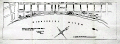 | Details | Pilie, Joseph | 1828 |
| Plan of the Front Part of the City of New Orleans in 1818. |
|
Pilie, Joseph |
|
| 1828 |
| LOC:0 |
| $0.00 | Pilie--Joseph | Plan-of-the-Front-Part-of-the-City-of-New-Orleans-in-1818- | SOLD … but see <a href="https://www.rarecharts.com/ShowDetail/Creator/Pilie--Joseph/Title/Original-Antique-Plan-of-New-Orleans-Waterfront/1386" target="_blank">another example of Pilie's plan here. </a>
<BR> </BR>
Scarce steel-engraved plan depicting the Mississippi River along New Orleans' French Quarter in 1818. |
| 1386 | 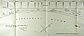 | Details | Pilie, Joseph | 1828 |
| Original Antique Plan of New Orleans Waterfront |
|
Pilie, Joseph |
|
| 1828 |
| LOC:0 |
| $0.00 | Pilie--Joseph | Original-Antique-Plan-of-New-Orleans-Waterfront | SOLD<BR> </BR>
Scarce, early 19th-century engraved plan by city surveyor Gilbert Joseph Pilie depicting the Mississippi (with only one "P") River waterfront with levee and wharfs along New Orleans' French Quarter. Shows the levees, wharves, and a few buildings along the first block fronting the Mississippi River.
<BR> </BR>
Signed by Jh. Pilie, New Orleans, Nov. 15th, 1827. According to "Charting Louisiana" Gilbert Joseph Pilie had been an assistant to Barthelemy Lafon after emigrating to the U.S. from Santo Domingo before 1805. (Lemmon, Magill, and Wiese eds. "Charting Louisiana: Five Hundred Years of Maps". 2003. p. 321.)
<BR> </BR>
Notable features include the water works, Custom House and Market Hall (that site now is home to the famous <s>Morning Call</s> Café du Monde coffee house where tourists line up for beignets and café au lait). Several street names have changed since that time (Iberville Street was then called Custom House Street) and Jackson Square is simply named "Public Square".
<BR> </BR>
From the "Memorial of the Mayor, Aldermen and Inhabitants of New Orleans". 20th Congress, 1st Session. Washington: Gales & Seaton, 1828. |
| 1228 | 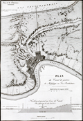 | Details | Poussin, Guillaume Tell | 1834 |
| Antique plan of New Orleans Louisiana ca. 1834 |
|
Poussin, Guillaume Tell |
|
| 1834 |
| LOC:0 |
| $0.00 | Poussin--Guillaume-Tell | Antique-plan-of-New-Orleans-Louisiana-ca--1834 | SOLD
<br></br>
Uncommon antique map or plan of New Orleans, Louisiana comprises the left half of the sheet. By William Tell Poussin (1796 - 1876), French architect, author, engineer, and diplomat.
<BR> </BR>
Detailed antique map of the New Orleans area shows the existing Carondolet Canal, Bienvenue Canal, and Treme Canal. The work also shows the proposed route of a canal to be constructed from the Mississippi River to Lake Ponchartrain running through the Faubourg Marigny along what is today Elysian Fields avenue. The canal was never constructed but in the 1830s the Ponchartrain Railway was built over the same route. The dream of a canal linking the lake with the river was not realized until 1923 with the opening of the Inner Harbor Navigation Canal (INHC), or "Industrial Canal".
<BR> </BR>
Includes a telling longitudinal elevation profile of the proposed canal from the Mississippi river to Lake Pontchartrain. Beginning at its highest point at the Mississippi River levee, the ground elevation along Elysian Fields Avenue declines gradually becoming "Forets inondees" until it crosses the Gentilly Ridge (an old natural levee) and the elevation increases.
<BR> </BR>
Right portion of the sheet contains a map of the Cheasapeake and Delaware Canal with a both a profile of the canal width and the canal length. Title on this half reads: "Plan de trace, situation des Ecluses, Nivellement general et Profile du Canal."
<BR> </BR>
Published in: "Travaux d'ameliorations interieures projetes ou executes par le Gouvernement General des Etats-Unis d'Amerique, de 1824 a 1831"; par Guillaume-Tell Poussin … Atlas. Paris, Anselin, Libraire, pour l'art militaire, les sciences et les arts, rue Dauphine, No. 36, dans le passage Dauphine. Carilian-Goeury, Libraire, des ponts et chaussees et des mines, Quai des Augustins, No. 41. 1834. Imprimerie de Lachevardiere, rue du Colombier, No. 30. |
| 1223 | 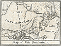 | Details | Anonymous | 1840 |
| Uncommon antique Map of Lake Pontchartrain |
|
Anonymous |
|
| 1840 |
| LOC:3 |
| $200.00 | Anonymous | Uncommon-antique-Map-of-Lake-Pontchartrain | Uncommon and unrecorded version of a lithographed map ca. 1840 of <b>Lake Pontchartrain</b> in Louisiana with three steamboat routes shown: to Madisonville, La., to Mandeville, La. and a mail steamboat route to Mobile, Alabama. Possibly by L. Hirt.
<br></br>
In 1834 it was reported that mail service was provided through three weekly round-trips between New Orleans and Mobile at a total annual cost of <a href="https://books.google.com/books?id=VfcaAAAAYAAJ&pg=PR1&dq=mail+steam+boat+mobile+new+orleans&source=gbs_selected_pages&cad=3#v=onepage&q=mail%20steam%20boat%20mobile%20new%20orleans&f=false" target="_blank">$40,000.</a></a>
<br></br>
This map appears as a vignette in L. Hirt's 1841 " Plan of New Orleans with Perspective and Geometrical Views of the Principal Buildings of the City" from <a href="http://louisdl.louislibraries.org/cdm/ref/collection/p15140coll28/id/76" target="_blank"> The Historic New Orleans Collection.</a> The present map shows signs of being disbound from a smaller volume. Scale: 3 inches to the mile. Louisiana History.
<br></br>
The map features Lake Borgne, Bayou Sauvage, and Bayou Bienvenue. Three steamboat routes terminate at Milneburg, at the north end of the Ponchartrain Rail Road on the south shore of Lake Pontchartrain. The Pontchartrain Rail-Road, the first railway in New Orleans, Louisiana began service in 1831. The route of the railway ran down the center of Elysian Fields Avenue from the Faubourg Marigny to the port of Milneburg, later the Lake Pontchartrain Amusement Park.
<br></br>
This scarce small map shows the city of New Orleans with Bayou St. John, the New Orleans canal, and the Carrolton Railroad. |
| 1224 | 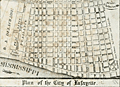 | Details | Anonymous | 1840 |
| Scarce antique map of New Orleans Tenth Ward or the City of Lafayette |
|
Anonymous |
|
| 1840 |
| LOC:3 |
| $250.00 | Anonymous | Scarce-antique-map-of-New-Orleans-Tenth-Ward-or-the-City-of-Lafayette | Unrecorded version of an early wood-cut map of <b>New Orlean's Tenth Ward</b> circa 1840 when it was known as <b>Lafayette City</b>. Earlier, during the French period New Orlean's Tenth Ward was known as the Faubourg Lafayette. Boundaries of Lafayette City include the Mississippi River, Felicity Street, Nayades Street (later known as St. Charles Avenue), and a large tract owned by R. A. Delachaise. Shows the New Orleans and Carrollton Railroad connecting the city of New Orleans to then then distant resort village of Carrollton.
<br></br>
Possibly by L. Hirt, and derived or re-purposed from his larger work. This map appears as a vignette in L. Hirt's 1841 " Plan of New Orleans with Perspective and Geometrical Views of the Principal Buildings of the City" from <a href="http://louisdl.louislibraries.org/cdm/ref/collection/p15140coll28/id/76" target="_blank"> The Historic New Orleans Collection.</a> The present map shows signs of being disbound from a smaller volume. Scale: 3 inches to the mile. Louisiana History.
<br></br>
Faubourg Lafayette was founded with small settlements around steamboat landings in New Orleans. The faubourg became the City of Lafayette, then part of Jefferson Parish and its first parish seat. Lafayette was a separate municipality until it was incorporated into New Orleans, Orleans Parish, in 1852. The present boundaries of the Tenth Ward include St. Charles Avenue, Jackson Avenue, the Pontchartrain Expressway, and Simon Bolivar Avenue. <a href="https://en.wikipedia.org/wiki/Faubourg_Lafayette" target="_blank"> (Source.)</a> |
| 1447 | 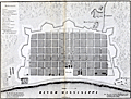 | Details | Pittman, Philip | 1853 |
| Uncommon lithographed map of New Orleans |
|
Pittman, Philip |
|
| 1853 |
| LOC:3 |
| $285.00 | Pittman--Philip | Uncommon-lithographed-map-of-New-Orleans | Uncommon lithographed map ca. 1853 of New Orleans, Louisiana as it appeared in 1770, based upon the reconnaissance of Captain Philip Pittman, a British army engineer. This lithographed mid 19th-century map is the earliest easily obtainable copy of Pittman's 1770 engraved map.
<br></br>
Lithographed by Sarony & Major. Sarony and Major were well known New York lithographers 1846-1853.
<br></br>
Pittman's book was the first English book on the topography, settlements, and inhabitants of the region. In 1764, he traveled the Mississippi River to New Orleans with Major Arthur Loftus.
<br></br>
The map was first printed as an engraved plate in Pittman's "The Present State Of The European Settlements On The Mississippi; with A Geographical Description of that River Illustrated by Plans and Draughts" (J. Nourse, London 1770).
<br></br>
About the site of New Orleans Pittman wrote:
<div class="indenttextblock">
NEW ORLEANS stands on the east side of the river, it has a very easy communication with the northern parts of Louisiana (now West Florida) by means of the Bayou of St. John, a little creek, which is navigable for small vessels drawing less than six feet water, six miles up from the lake Ponchartain, where there is a landing-place, at which the vessels load and un load ; and this is about two miles from the city.
</div>
Pittman described the area around Jackson Square, and St. Louis Cathedral, perhaps New Orleans best-known locations (café du Monde, street artists, carriage rides):
<div class="indenttextblock">
The parade is a large square, in the middle of that part of the town which fronts the river ; in the back part of the square is the church dedicated to St. Louis, a very poor building, framed with wood ; it is in so ruinous a condition that divine service has not been performed in it since the year 1766, one of the king's store houses being at present used for that purpose.
</div> |
| 382 |  | Details | Anonymous | 1853 |
| Lake Pontchartrain Harbour and Breakwater |
|
Anonymous |
|
| 1853 |
| LOC:10 |
| $225.00 | Anonymous | Lake-Pontchartrain-Harbour-and-Breakwater | Fascinating plan of the southern shore of Lake Ponchartrain in New Orleans, Louisiana from 1853. During that era both Bayou St. John and the New Canal (the present <a rel="nofollow" target="_blank" href="http://en.wikipedia.org/wiki/17th_Street_Canal">17th Street Canal</a>) were navigable to small vessels; a lighthouse is shown at the mouth of each canal. The plan shows projected construction of wooden breakwaters in the lake that were designed "to furnish safe anchorage in front of the termini of the Pontchartrain Railroad, Bayou St John, and New Canal…".<BR> </BR>
Other depicted features include Milneburg, then a suburb of New Orleans connected to it by the Pontchartrain Railroad, two lighthouses, and the Jefferson and Lake Pontchartrain Railroad in what is now Jefferson Parish. Construction details of the wooden breakwater are shown in profile and elevation. <BR> </BR>
Today neither of the two railroad lines linking New Orleans to the Lakefront exist. Neither Bayou St. John nor the 17th Street Canal (a large drainage ditch) are navigable. In fact a section of the 17th Street Canal failed after Hurricane Katrina and was responsible for flooding a large part of New Orleans and at least 31 deaths. The deadly breach in the canal can be located on the plan near the bottom of the shaded high land directly adjacent to the New Canal. <BR> </BR>
Dated October 30th, 1853. Printed by Wagner and Mc Guigan Lithographers, Philadelphia. For reference see: |
| 6738 |  | Details | Soule, George | 1859 |
| Very Rare Antebellum New Orleans advertisement Soule Commercial College |
|
Soule, George |
|
| 1859 |
| LOC:150 |
| $6,500.00 | Soule--George | Very-Rare-Antebellum-New-Orleans-advertisement-Soule-Commercial-College | Very rare New Orleans imprint antebellum broadsheet advertisement or "Balance Sheet Circular" produced by George Soule to advertise Soule's Commercial College, established 1856 at the corner of Camp Street and Common Street, in New Orleans, Louisiana. A finely detailed lithograph featuring exquisite calligraphy, numerous inset views of commercial activities, and four example financial statements, including at bottom right, "Statement of Steamer Eclipse Trip No. 8 T.R. Winn Master."
<br><br>
An online search found only one copy of Soule's "Balance Sheet Circular", at the Historic New Orleans Collection.
<br><br>
<div id="6738" align="center">
<a title=""></a>
<img id="6738" src="/ZoomifyImages/SC_6738/SC_6738_400x300.jpg" alt=" Antebellum advertisement for Soule's Commercial College, established 1856 in New Orleans, LA." width="340"/> <br><br> <font size="-2">Soule's Commercial College Balance Sheet Circular</font>
</div><br>
Lithographed by J. Manouvrier. (2) This fine lithograph with beautiful calligraphy was printed in New Orleans in 1859, just after Soule opened the College at Camp and Common Streets. Between 1856 and 1860 Soule's Commercial College graduated a total of more than 275 students. By 1905 the school could boast 1000 students enrolled, 20 teachers, and over 19,000 former students. The school operated in New Orleans continuously, except for a few years during the Civil War, until 1983 when it finally closed.
<br><br>
<div id="6738_2" align="center">
<a title=""></a>
<img id="6738_2" src="/ZoomifyImages/SC_6738/SC_6738_Detail_2.jpg" alt=" Antebellum advertisement for Soule's Commercial College, a view of Jackson Square." width="340"/> <br><br> <font size="-2">Early View of Jackson Square, New Orleans</font>
</div> |
| 1426 | 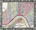 | Details | Mitchell, Samuel Augustus | 1860 |
| Antebellum Map of New Orleans, Louisiana |
|
Mitchell, Samuel Augustus |
|
| 1860 |
| LOC:0 |
| $0.00 | Mitchell--Samuel-Augustus | Antebellum-Map-of-New-Orleans--Louisiana | NOT AVAILABLE
<br></br>
Attractive antique map from 1860 of New Orleans, Louisiana with 11 of its 17 wards. On the West Bank of the Mississippi River three early neighborhoods are identified by their old (current) name: Algiers (Algiers Point); MacDonough (McDonogh), and Belle Ville (Whitney). Most of the boundaries of Wards 1 through 11 were drawn in 1852 when the city was reorganized into one centralized political entity. <a href="https://en.wikipedia.org/wiki/Wards_of_New_Orleans" target="_blank">Online. </a>
<br></br>
This neat, colorful old map clearly shows several early canals which evolved for both drainage and transport over a long period. For example the Carondelet Canal or Old Basin Canal, was a canal in New Orleans, operating for almost 135 years- from 1794 into the 1920s. The canal started at Bayou St. John, which connected with Lake Pontchartrain, and went inland to what was then the back edge of New Orleans, in the Tremé neighborhood. The two-acre turning basin at the head of the Canal inspired the naming of Basin Street in New Orleans.
<br></br>
Attribution at bottom reads: Entered according to Act of Congress, in the year 1860 by S. Augustus Mitchell Jr. in the clerks office of the District Court of the U.S. for the eartern District of Pennsylvania. Number 33.
<br></br>
Samuel Augustus Mitchell Sr. (1792-1868) is one of the pioneers in American cartography of the 19th century and led the conversion of engraved map plates to more affordable lithographic plates. |
| 1272 | 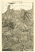 | Details | Anonymous | 1866 |
| Antique Birds Eye View of the Mississippi Basin |
|
Anonymous |
|
| 1866 |
| LOC:0 |
| $0.00 | Anonymous | Antique-Birds-Eye-View-of-the-Mississippi-Basin | SOLD
<br></br>
Unusual post-war antique wood engraving of a birds eye view of the <b>Mississippi basin</b> with numerous rivers, roads and cities identified by name. With this image the viewer looks at the landscape from a new perspective with South at the top of page. Attractive.
<br></br>
<div class="indenttextblock"> "Wood engraving is a printmaking and letterpress printing technique, in which an artist works an image or matrix of images into a block of wood. Functionally a variety of woodcut, it uses relief printing, where the artist applies ink to the face of the block and prints using relatively low pressure. By contrast, ordinary engraving, like etching, uses a metal plate for the matrix, and is printed by the intaglio method, where the ink fills the valleys, the removed areas. As a result, wood engravings deteriorate less quickly than copper-plate engravings, and have a distinctive white-on-black character." (Source: <a href="https://en.wikipedia.org/wiki/Wood_engraving" target="_blank">INTERNET</a> )
</div>
<BR/>
Coverage extends from St. Louis to the Gulf of Mexico and beyond with dozens of cities and town noted including Austin, Texas; Key West, Florida; New Orleans, Louisiana; Brownsville, Galveston, Montgomery, Jackson, Knoxville, Charleston, Savannah, Vicksburg, Natchez and many more.
<br></br>
Includes the Mississippi River, Missouri River, Ohio River, Arkansas River, Savannah River, Chattahoochee River, Escambia River, and the upper Gulf of Mexico. Published in 1866 by Harpers for the "Pictorial History of the Civil War" part 1. |
| 931 | 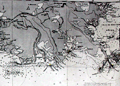 | Details | James Imray and Son | 1876 |
| Gulf of Mexico New Orleans to Tampico Mexico |
|
James Imray and Son |
|
| 1876 |
| LOC:1409 |
| $4,800.00 | James-Imray-and-Son | Gulf-of-Mexico-New-Orleans-to-Tampico-Mexico | A spectacular, huge (6' foot) antique British privately-published blueback nautical chart of the western Gulf of Mexico in very fine condition. Scarce to find this chart, especially an example kept in such great shape as this one. Chart coverage includes United States coastal areas from New Orleans, Louisiana trending west and then south to Tampico, Mexico. Contains the oval blue inked over-stamp that reads "James Imray and Son, 1876, London."
<br></br>
<b>Note:</b> Because of its large size the photo is stitched together from 2 halves. Some abberations in the image may appear.
<br></br>
This old chart is dotted with numeous inset large-scale charts of key ports and important bays, rivers and harbors including: Galveston, Texas; Atchafalya Bay, Louisiaana, Sabine Pass, Matagorga Bay, Rio Grande, and Tampico, Mexico.
<br></br>
During the 1800's there was a trend toward publication of very large small-scale charts with large-scale insets of key passages and harbors. The practice was adopted as much for economics as any other reason. James Imray and Son was one of a handful of British publishers who specialized in these charts which were often backed with canvas or linen cloth or heavy blue paper in order to help them withstand the frequent use and abuse aboard ship, hence the term "blueback chart".
<br></br>
Outer blue paper contains yellow a large seller's label with the logo of James Imray amd Son.
Price when sold 10 s. |
| 1240 |  | Details | Cincinnati and New Orleans Passenger Line | 1880 |
| Trade card for Steamboat Charles Morgan |
|
Cincinnati and New Orleans Passenger Line |
|
| 1880 |
| LOC:0 |
| $180.00 | Cincinnati-and-New-Orleans-Passenger-Line | Trade-card-for-Steamboat-Charles-Morgan | Very interesting and rare antique trade card for the side-wheel <b>steamboat Charles Morgan</b> of the Cincinnati and New Orleans Passenger Line. Built in 1873 and burned in Cincinnati in 1886, the Charles Morgan is well known for having Samuel Clemens a.k.a. Mark Twain as a passenger in 1882 when Clemens took a nostalgic tour to revisit places along the Mississippi River that he had visited in his previous occupation as a riverboat pilot.
<br><br/>
Front of the card contains an image resembing the steamer Charles Morgan. Verso contains the names and distances for approximately 100 of the steamboat stops along the route from Cincinnati to New Orleans, a total. distance of 1440 miles.
<br><br/>
The Charles Morgan was named for its owner, shipping tycoon Charles Morgan (1795-1878). Morgan moved to New York City at the age of fourteen and began a ship chandlery and import business which lead to investments in merchant shipping and ironworks and to management of several lines of sailing and steam packets trading with the South and the West Indies. He was also both partner and rival of Cornelius Vanderbilt in attempts to establish an isthmian transit across Nicaragua in the 1850s.
<br><br/>
Morgan City, Louisiana was named after Charles Morgan. |
| 7948 | 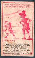 | Details | Cosgrove, John | 1880 |
| Trade Card for John Cosgrove Poydras Market New Orleans |
|
Cosgrove, John |
|
| 1880 |
| LOC:41 |
| $150.00 | Cosgrove--John | Trade-Card-for-John-Cosgrove-Poydras-Market-New-Orleans | Antique trade card advertising for John Cosgrove, a wholesale and retail dealer in fish, turtle, shrimps, crabs, pompano, red fish, snapper, and other seasonal fish at Poydras Market in New Orleans. Date is estimated as circa 1880.
<br><br>
The Poydras Market was a major public food market in 19th-century New Orleans, strategically located on Poydras Street near the Mississippi River and just west of the French Quarter. It was part of a network of municipal markets established to supply the city’s growing population with fresh produce, meats, and seafood. Its proximity to the riverfront made it an ideal site for offloading goods brought in by boat, especially the bounty of the Gulf—shrimp, crabs, pompano, redfish, turtle, and snapper were staples of the stalls.
<br><br>
The market was a bustling commercial hub where independent vendors, such as John Cosgrove, rented numbered stalls to sell seasonal goods. These vendors catered to a diverse clientele that included chefs, homemakers, and restaurateurs, all drawn by the variety and freshness of the offerings. The open-sided structure, typical of Southern markets, allowed for good airflow in the subtropical climate and fostered a lively, communal atmosphere filled with the sounds and scents of everyday commerce.
<br><br>
By the early 20th century, however, changes in transportation, refrigeration, and shopping habits began to erode the dominance of public markets. Poydras Market gradually declined and was eventually demolished—likely by the mid-20th century—as downtown New Orleans transformed into a modern commercial district. While the physical market is long gone, its name and legacy endure in the city’s culinary memory and in rare trade ephemera like this advertising card. |
| 1390 | 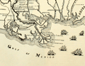 | Details | Lane, Walter A. | 1884 |
| Antique Civil War era map of the Gulf Coast |
|
Lane, Walter A. |
|
| 1884 |
| LOC:0 |
| $0.00 | Lane--Walter-A- | Antique-Civil-War-era-map-of-the-Gulf-Coast | SOLD
<br></br>
Neat decorative original antique map of the southeast Gulf Coast during the U.S. Civil War. Includes locations and features in Texas, Louisiana, Mississippi, Alabama, Florida and the surrounding states. Shows key forts including Fort Pike, Fort Pickens, Fort Jackson, Fort St. Philip and Fort McComb. Includes numerous railroad lines, the key to rapid re-supply. Lane shows and names all the Mississippi River passes (ex. "Pass a Loutre") and fills the empty space in the Gulf of Mexico with depictions of six sailing vessels, some with obvious smoke stacks signifying the use of steam power to assist the sails.
<br></br>
From "The Soldier in Our Civil War" by Frank Leslie. Text and wood-cut images on verso. Dotted line shows the path of Grierson's raid, an attack by 1700 Union cavalry on Baton Rouge, Lousiana in 1863 over routes no Union soldier had traveled prior to the raid. |
| 158 |  | Details | Mugnier, George Francois | 1884 |
| Lower Levee, Shipping |
|
Mugnier, George Francois |
|
| 1884 |
| LOC:0 |
| $0.00 | Mugnier--George-Francois | Lower-Levee--Shipping | SOLD <BR> </BR>
Handsome, detailed, antique albumen cabinet card by New Orleans photographer George Francois Mugnier, taken early in his career circa 1884. Subjects are several 3-masted sailing vessels docked at a New Orleans wharf. Vessel closest to the wharf has sails partially unfurled, possibly to allow them to dry. Also, in the far background a sailor is seen climbing the rigging of another ship. <BR> </BR>
The ship farthest from the wharf can be identified under magnification as the "Glen Grant". On the Canadian Heritage on-line reference library we find 5 voyages by a vessel named "Glen Grant" (official # 69115) to the U.S. Gulf Coast including a round-trip voyage from England to a single Gulf port, unnamed, departing September 1882, returning March 1883. It is possible that this photo was taken during that voyage by Mugnier. <BR> </BR>
Bottom of photo reads: "Mugnier, Photographer Exchange Place N.O. La." Mugnier (1855-1936) achieved fame as a photographer with his 1885 photographs of the World's Industrial and Cotton Centennial Exposition in New Orleans. Number 538. Blank, pinkish verso. |
| 5375 | 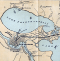 | Details | Louisville and Nashville Railroad | 1886 |
| Birds Eye View of Gulf Coast Louisville and Nashville Railroad |
|
Louisville and Nashville Railroad |
|
| 1886 |
| LOC: |
| $725.00 | Louisville-and-Nashville-Railroad | Birds-Eye-View-of-Gulf-Coast-Louisville-and-Nashville-Railroad | </br>"The Great Through Car Line Between the North and South."</br>
"Unrivaled in Speed, Construction and Equipment."
<br></br>
Fine bird's eye view of the central Gulf Coast highlighting the route of the Louisville and Nashville Railroad from Mobile, Alabama, through Mississippi, to New Orleans, Louisiana. The route includes Bay St. Louis, Ocean Springs, Pass Christian, Mississippi City, Biloxi, Pascagoula. Numerous steam-powered and wind-powered vessels are shown plying the waters of the Gulf of Mexico, Lake Ponchartrain and the Mississippi River.
<br></br>
Six-panel folding map, neatly folded inside a 64-page pamphlet (4.5 " x 7.25") titled "The Gulf Coast". With the ink stamp of Sam. B. Jones, General Agent, New York. Published by the passenger department of the Louisville and Nashville R.R.
<br></br>
Printed in Louisville, KY by the Press of the Courier-Journal Job Printing Company. |
| 340 |  | Details | U.S. Geological Survey | 1892 |
| Mouth of the Mississippi River |
|
U.S. Geological Survey |
|
| 1892 |
| LOC:0 |
| $0.00 | U-S--Geological-Survey | Mouth-of-the-Mississippi-River | SOLD
<BR> </BR>
Small antique lithographed chart of the Mouth of the Mississippi River. The chart, from the U.S. Geological Survey, is derived from a U.S. Coast Survey chart and overlaid with hachured topographic details. Lighthouses, soundings, life saving stations and navigational aids are shown. Water shown in blue. Some of the features shown include Lake Ponchartrain, Timbalier Pass, Bayou Lafourche, Pass Fourchon, Chandeleur Islands, Biloxi, and Pass Christian. <BR> </BR>
Produced for the U.S. Geological Survey Thirteenth Annual Report. Produced by George S. Harris Lithographers, Philadelphia. Plate 22. |
| 383 | 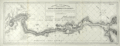 | Details | U.S. Army Engineers | 1893 |
| Barataria and Lake Borgne Levee Districts 1893 |
|
U.S. Army Engineers |
|
| 1893 |
| LOC:0 |
| $0.00 | U-S--Army-Engineers | Barataria-and-Lake-Borgne-Levee-Districts-1893 | SOLD
<BR> </BR>
Draftsman-style map of the lower Mississippi River from New Orleans to the Mississippi River passes. Depicts the levees constructed along the Mississippi River in the 1892-1893 season. The map names levee improvements circa 1893 in Orleans, St. Bernard, Jefferson and Plaquemines parishes with Mississippi river mileage from Cairo, Illinois shown at 5 mile intervals. New Orleans is shown as it existed in 1893 with the northern half of the city to Lake Ponchartrain yet to be developed. <BR> </BR>
Key points along the river that are identified include Southwest Pass, the Jump, Tropical Bend, Devils Plate, Fort Jackson and English Turn. Lines of latitude and longitude. Plate VII. Dated June 1, 1893. <BR> </BR> |
| 1478 |  | Details | U.S. Army Engineers | 1894 |
| Barataria and Lake Borgne Levee Districts 1894 |
|
U.S. Army Engineers |
|
| 1894 |
| LOC:0 |
| $90.00 | U-S--Army-Engineers | Barataria-and-Lake-Borgne-Levee-Districts-1894 | Draftsman-style map of the lower Mississippi River from New Orleans to the Mississippi River passes. Depicts the levees constructed along the Mississippi River from June 1894. The map names levee improvements circa 1894 in Orleans, St. Bernard, Jefferson and Plaquemines parishes with Mississippi river mileage from Cairo, Illinois shown at 5 mile intervals. New Orleans is shown as it existed in 1894 with the northern half of the city to Lake Ponchartrain yet to be developed.
<BR> </BR>
Key points along the river that are identified include Southwest Pass, the Jump, Tropical Bend, Devils Plate, Fort Jackson and English Turn. Lines of latitude and longitude. Plate VII. Dated June, 1894. <BR> </BR> |
| 5371 | 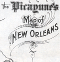 | Details | Daily Picayune | 1901 |
| The Picayune's Map of New Orleans |
|
Daily Picayune |
|
| 1901 |
| LOC:90 |
| $400.00 | Daily-Picayune | The-Picayune-s-Map-of-New-Orleans | Scarce lithographed map of New Orleans, Louisiana published by The Picayune [1] newspaper in 1901. Shows both the West End Railroad and the Ponchartrain Railroad, both now long gone.
<br></br>
The Mississippi River is shown devoid of bridges but with <b>nine ferry crossings</b>. The first bridge across the Mississippi in Louisiana was not built until 1935. Several paddlewheel steamboats are shown underway in the river
<br></br>
The Picayune newspaper was started in 1837 in New Orleans, Louisiana. In 1914 The Picayune merged with the Times-Democrat to form the Times-Picayune.
<br></br>
[1] The Picayune was named after a Spanish coin used in Florida and Louisiana worth about six and one-half cents in the 1850s. |
| 557 |  | Details | U.S. Coast and Geodetic Survey | 1914 |
| 1914 Inside Route Pilot Key West to New Orleans |
|
U.S. Coast and Geodetic Survey |
|
| 1914 |
| LOC:2001 |
| $400.00 | U-S--Coast-and-Geodetic-Survey | 1914-Inside-Route-Pilot-Key-West-to-New-Orleans | Very scarce, intact 1914 Coast Pilot with six strip charts and sailing directions for what is now the Gulf Intracoastal Waterway, from Key West, Florida heading north and then west to New Orleans, Louisiana. Published by the U.S. Coast and Geodetic Survey. Contains 93 pages of text plus an index.
<br><br/>
In its early history some portions of the 'inside route' were owned and dredged by private entities who charged a toll to vessels for passage, sometimes by stringing a chain across narrow passages to restrict traffic flow. After 1919 Congress mandated that the entire passage should be turned over to the Federal government and the tolls were eliminated.
<br><br/>
The sailing directions for Bayou St. John describe a moment in time that New Orleans residents can only imagine today: <dir class="indenttextblock">The channel at the entrance is protected by training walls on each side. Spanish Fort is a pleasure resort at the mouth of Bayou St. John and is connected with New Orleans by an electric car line... Small craft of all kinds use the bayou as far as Esplanade Street, about 2 3/4 miles above the entrance, but pleasure boats rarely go above that point." </dir>
Size of each chart when folded is approximately 8" x 5". The pilot's lithographed working navigational charts capture the full extent of the southern U.S. Inside Route in detail. Chart sections include roughly these areas and chart sizes: (fully opened, height is 10" and width is listed below). <br>
1. Key West to Matanzas Pass - 24"<br>
2. Matanzas Pass to Clearwater - 23"<br>
3. Clearwater to Tampa - 27"<br>
4. Tampa to St. Andrews Sound - 24"<br>
5. St. Andrews Sound to Bay St. Louis - 36"<br>
6. Bay St. Louis to New Orleans. - 23"<br>
<br><br/>
If they were placed end to end, the charts would extend over 13 feet long. Original price 20 cents. Published by the Government Printing Office in Washington DC in 1915. |
| 4908 |  | Details | Higgins Tours | 1922 |
| Pre-depression map and brochure for Higgins Tours in New Orleans |
|
Higgins Tours |
|
| 1922 |
| LOC:0 |
| $140.00 | Higgins-Tours | Pre-depression-map-and-brochure-for-Higgins-Tours-in-New-Orleans | Scarce brochure, with a map (9"x16") of Orleans Parish, for tours of New Orleans, Louisiana by Higgins Tours. In 1922 Higgins Tours' office and garage was at 630 Julia Street, part of what later was to become New Orleans's skid row in the 1970's, and today is part of the revitalized warehouse district.
<br></br>
On the back cover an offer for Higgin's Plantation Tour for $2.00 round trip: "30 Miles on LOUISIANA Shell Roads". Oooh, pinch me! Special points of interest on the Plantation Tour included St. Roch's Shrine, famous old Villere Plantation, slave huts and orange groves. Cars left daily from the corner of Canal and St. Charles Street at 10:00 a.m. and 1:30 p.m. daily. "Look for the green cars."
<br></br>
Light card cover and four interior sheets front and back. Fare $1.00. Printed ca. 1922. |
| 5091 | 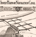 | Details | Board of Commissioners of the Port of New Orleans | 1923 |
| Early Map of New Orleans Inner Harbor Navigation Canal |
|
Board of Commissioners of the Port of New Orleans |
|
| 1923 |
| LOC:3 |
| $250.00 | Board-of-Commissioners-of-the-Port-of-New-Orleans | Early-Map-of-New-Orleans-Inner-Harbor-Navigation-Canal | Scarce early promotional map in an advertisement for the New Orleans Inner Harbor Navigation Canal (the Industrial Canal), a 5 1/2 mile waterway linking Lake Ponchartrain to the Mississippi River. Published from New Orleans, Louisiana by the Board of Commissioners of the Port of New Orleans in 1923, the year the canal opened.
<br></br>
At center right is shown a "possible location of deep-sea connection", a concept that was later, in 1965, to become the Mississippi River Gulf Outlet (MRGO) providing a shorter link for shipping traffic from New Orleans to the Gulf of Mexico.
<br></br>
Published in the May 12, 1923 edition of The Traffic World Magazine by the Traffic Service Corporation. Volume XXXI No. 19. P. 1090. |
| 5350 |  | Details | Speck, Rose M. | 1934 |
| Mississippi River paddleboat cruise to New Orleans broadside |
|
Speck, Rose M. |
|
| 1934 |
| LOC:9 |
| $625.00 | Speck--Rose-M- | Mississippi-River-paddleboat-cruise-to-New-Orleans-broadside | Rare original 1934 broadside for a two week Mississippi River cruise aboard the paddleboat Cape Girardeau. The event, limited to 100 passengers, was planned to depart New York on March 31, 1934 and was sponsored by Rose M. Speck of New York City.
<br></br>
<b>"Two weeks of Adventure on the Lower Section of the Mighty Mississippi -- Aboard the picturesque steam packet "Cape Girardeau"-- Monarch of the River"</b>
<br></br>
The $139 fare included a pullman train from New York to Memphis, Tennessee complete with a recreation car. Aboard the riverboat, passengers could plan on a two-day layover in New Orleans along with onboard entertainment including:
<div class="indenttextblocksingle">
<ul style="list-style-type: circle;">
<li>"Darkey spiritual singers"</li>
<li>Square dances</li>
<li>Costume balls</li>
<li>Masquerades</li>
<li>Deck sports</li>
<li>Sun baths</li>
<li>Swimming in the Gulf of Mexico</li>
</ul>
</div> |
| 1333 |  | Details | U.S. War Department | 1934 |
| Old War Department Map of New Orleans Area 1934 |
|
U.S. War Department |
|
| 1934 |
| LOC:1401 |
| $450.00 | U-S--War-Department | Old-War-Department-Map-of-New-Orleans-Area-1934 | Large, original War Department / U.S. Corps of Engineers blueprint index map from 1934 for south-eastern Louisiana including New Orleans, Donaldsonville, Baton Rouge, Mandeville, Slidell and Bay St. Louis. Names railways, numerous waterways and bodies of water, but does not show roads or highways. Includes the Bonnet Carre Floodway (completed 1931), the Harvey Locks, portions of the Intracoastal Canal (later called the Gulf Intracoastal Waterway or ICWW), Lake Borgne, Lake Ponchartrain, Barataria Bay, Atchafalaya Bay, and the Mississippi River as far south as Venice, Louisiana. Perfect for the man cave.
<br></br>
On this map the route shown for the Intracoastal Canal passes through Lockport, Louisiana and Bayou Terrebonne. The segment of the canal from Larose to Bourg, Louisiana to was not completed until 1949.
<br></br>
Dated within at bottom right to 1934. Drawn by L. Lecaze. |
| 5430 | 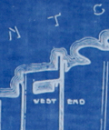 | Details | Anonymous | 1938 |
| Detailed map Railroads Interchanges, and Terminals New Orleans Louisiana |
|
Anonymous |
|
| 1938 |
| LOC:1401 |
| $900.00 | Anonymous | Detailed-map-Railroads-Interchanges--and-Terminals-New-Orleans-Louisiana | Original unrecorded blueprint (cyanotype) map of the railroad network in New Orleans in 1938. At a high level, the map shows the ownership and location of railroad tracks, interconnections (Interchanges) between railroad lines, and input/output points to the rail system (Terminals). Includes parts of the West Bank communities of Avondale, Westwego, Marrero, Harvey, Gretna, and Algiers. Also clearly shows the Industrial Canal (opened 1923) [1] and the New Orleans Lakefront Airport, then the Shushan Airport (opened 1934).
<br></br>
Shows the West End (remember Brunings? Fitzgerald's?) and the <strong> New Basin Canal</strong>, now long filled.
<br></br>
For many years New Orleans was a key seaport. Its location allowed access to large ships (cutting edge technology at that time) from across the world and provided a water route into the heart of the United States that favored movement of bulk goods and people.
<br></br>
At extreme upper left is a numerical index to key streets and locations in New Orleans (e.g. Julia Street, N.O. Cooperative Butchers Abattoir, and the Cotton Warehouse and Elevator). Below that is an index to the location of railroad interchanges and to support locations for railroad logistics operations: Engine Houses, Train Yards, Freight Depots, and Passenger Depots.
<br></br>
[1] More correctly known as the Inner Harbor Navigation Canal (IHNC). The IHNC connects the Mississippi River with Lake Ponchartrain. |
| 6516 |  | Details | Barnes, Myra Zimmerman | 1942 |
| Pictorial plan of New Orleans French Quarter of Vieux Carre |
|
Barnes, Myra Zimmerman |
|
| 1942 |
| LOC: |
| $375.00 | Barnes--Myra-Zimmerman | Pictorial-plan-of-New-Orleans-French-Quarter-of-Vieux-Carre | Very attractive lithographed pictorial map of the Vieux Carre (French Quarter) in New Orleans, Louisiana. Rolled with no folds. Barnes based the overall scope of her map and details on the walls surrounding the Vieux Carre on plans produced by surveyors Carlos Trudeau and Joseph Pilie from 1794 through 1808. Over this early framework Barnes has illustrated local architecture and history with elements of contemporary culture from the early 1940s .
<br><br>
The border is surrounded by vignettes of New Orleans and Louisiana history and culture as it existed in 1942 when Barnes created the map, as well as important key events such as two fires in 1788 and 1794 that destroyed many of the early wooden French structures in the city.
<div class="indenttextblocksingle">
<ul>
<li>The Southern Yacht Club</li>
<li>The Fairgrounds</li>
<li>The Bonnet Carre Spillway</li>
<li>Cutting sugar cane</li>
<li>Suicide Oak</li>
</ul>
</div> |
| 2539 | 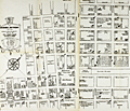 | Details | Miller and Jones | 1944 |
| Map of New Orleans Storyville Jazz and Red-Light District |
|
Miller and Jones |
|
| 1944 |
| LOC:0 |
| $0.00 | Miller-and-Jones | Map-of-New-Orleans-Storyville-Jazz-and-Red-Light-District | SOLD<br></br>
Map of Storyville jazz and red-light district in the Faubourg Treme neighborhood of New Orleans, Louisiana. Redrawn from an earlier map. Storyville was a 38-block area of New Orleans in which prostitution was tolerated between 1897 and 1917. The streets bounding the Storyville district were Iberville, Basin, St. Louis, and North Robertson streets.
<br></br>
Redrawn by Paul Edward Miller and Richard M. Jones from an earlier edition. |
| 1010 | 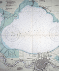 | Details | U.S. Coast and Geodetic Survey | 1946 |
| Lakes Pontchartrain and Maurepas, Louisiana |
|
U.S. Coast and Geodetic Survey |
|
| 1946 |
| LOC:0 |
| $0.00 | U-S--Coast-and-Geodetic-Survey | Lakes-Pontchartrain-and-Maurepas--Louisiana | SOLD
<br></br>
Modern 70 year-old chart of South Louisiana focused on Lake Pontchartain and New Orleans. Key features are the chart's fine unblemished condition and the absence of the Lake Ponchartrain Causeway Bridge. A series of lighted bouys extends from the south shore in Metairie to the north shore near Mandeville. Little development shown in Metairie as expected.
<BR></BR>
Published in 1943 but this edition was published with corrections in 1946. |
| 6504 |  | Details | McClure, Jim | 1973 |
| Fine etching of the New Orleans French Market |
|
McClure, Jim |
|
| 1973 |
| LOC:78 |
| $300.00 | McClure--Jim | Fine-etching-of-the-New-Orleans-French-Market | Fine limited-edition etching of life at the French Market in New Orleans, Louisiana. Very nicely and accurately captures the mood and atmosphere of the French Market and French Quarter in the early 1970's. Titled, dated and signed by the artist. No. 105 of 200. |
| 6533 | 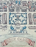 | Details | Fell, April P. | 1976 |
| Plan New Orleans Vieux Carre by April Fell |
|
Fell, April P. |
|
| 1976 |
| LOC:68 |
| $375.00 | Fell--April-P- | Plan-New-Orleans-Vieux-Carre-by-April-Fell | Scarce plan of the Vieux Carre or French Quarter in New Orleans, Louisiana by April P. Fell in 1976. Shows the buildings and street layout of the French Quarter as they existed in 1976. The limits of the Vieux Carre are the Mississippi River, Canal Street, Rampart Street, and Esplanade Avenue.
<br><br>
Todd and April Fell lived in New Orleans beginning in the 70s. They created a travel book called 'The Vignette' that was published until 1987.
<br><br>
Published by The Vignette 240 Rue Chartres. Copyright 1976. |