| | Thumbnail | | Creator | Date | Title / Author / Date / Location | Price | | | Description |
| 167 | 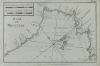 | Details | Roux, Joseph | 1764 |
| Rade de Marseille |
|
Roux, Joseph |
|
| 1764 |
| LOC:4 |
| $110.00 | Roux--Joseph | Rade-de-Marseille | Antique chart engraving of the Bay of Marseille from the atlas of Mediterranean ports produced by Joseph Roux.<BR> </BR>
There were at least four small atlases of port and coastal charts that originated from Marseille hydrographers in the 18th century. Beginning in approximately 1727 these atlases included works by cartographers
<a rel="nofollow" href= "/MichelotBremondBackground.aspx"> Michelot and Bremond</a>,
<a rel="nofollow" href= "/Creator/Ayrouard--Jacques"> Jacques Ayrouard</a>,
<a rel="nofollow" href= "/Creator/Roux--Joseph"> Joseph Roux</a>
, and Jean Allezard. Comparison between Roux's chart of Marseille Bay and that of Michelot and Bremond shows that although Roux's coastal outline is slightly different than Michelot, the hydrographic soundings were lifted directly from Michelot's charts that were produced 40 years earlier. Plate 20. |
| 168 | 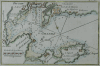 | Details | Roux, Joseph | 1764 |
| Toulon (Sold) |
|
Roux, Joseph |
|
| 1764 |
| LOC:0 |
| $0.00 | Roux--Joseph | Toulon-(Sold) | SOLD<BR> </BR>
Antique engraving of the French port of Toulon from the atlas of Mediterranean ports produced by Joseph Roux. The old nautical chart concentrates on the harbor around Toulon and its surrounding area, including forts St. Louis, Balaguie, Leguillette, and the larger Fort de la Marque.<BR> </BR>
There were at least four small atlases of port and coastal charts that originated from Marseille hydrographers in the 18th century. Between approximately 1720 and 1760 these atlases included works by cartographers
<a rel="nofollow" href= "/MichelotBremondBackground.aspx"> Michelot and Bremond</a>,
<a rel="nofollow" href= "/Creator/Ayrouard--Jacques"> Jacques Ayrouard</a>,
<a rel="nofollow" href= "/Creator/Roux--Joseph"> Joseph Roux</a>
, and Jean Allezard. |
| 997 | 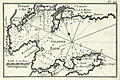 | Details | Roux, Joseph | 1764 |
| Toulon, France harbor |
|
Roux, Joseph |
|
| 1764 |
| LOC:4 |
| $95.00 | Roux--Joseph | Toulon--France-harbor | Antique engraving of the French port of Toulon, France from the atlas of Mediterranean ports produced by Joseph Roux. The old nautical chart concentrates on the harbor around Toulon and its surrounding area, including forts St. Louis, Balaguie, Leguillette, and the larger Fort de la Marque.
<BR> </BR>
Published in Roux's : "Recueil des principaux plans des Ports et Rades de la Mer Mediterranee …" including 121 harbor plans.
<BR> </BR>
There were at least four small atlases of port and coastal charts that originated from Marseille hydrographers in the 18th century. Between approximately 1720 and 1760 these atlases included works by cartographers
<a rel="nofollow" href= "/MichelotBremondBackground.aspx"> Michelot and Bremond</a>,
<a rel="nofollow" href= "/Creator/Ayrouard--Jacques"> Jacques Ayrouard</a>,
<a rel="nofollow" href= "/Creator/Roux--Joseph"> Joseph Roux</a>
, and Jean Allezard.
<BR> </BR>
Plate 23 |
| 627 | 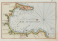 | Details | Roux, Joseph | 1764 |
| Bay of Gibraltar and Algeciras |
|
Roux, Joseph |
|
| 1764 |
| LOC:4 |
| $200.00 | Roux--Joseph | Bay-of-Gibraltar-and-Algeciras | Attractive antique nautical chart by Joseph Roux of the environs around the Bay of Gibraltar in the southwest Mediterranean Sea.
<BR> </BR>
This small original copperplate-engraved chart covers from the British Overseas Territory of Gibraltar in the east to the town of Algeciras in the west with plentiful soundings, sea hazards, and anchorages identified. Named features include numerous lookout towers, Rio Guadarranque ( Cuaranque ), Rio Palamones ( Riviere des Promones ), Fort St. Roch, Fort St. Philippe. Oriented with north to the left. <BR> </BR>
There were at least four small atlases of port and coastal charts that originated from Marseille hydrographers in the 18th century. Beginning in approximately 1727 these atlases included works by cartographers
<a rel="nofollow" href= "/MichelotBremondBackground.aspx"> Michelot and Bremond</a>,
<a rel="nofollow" href= "/Creator/Ayrouard--Jacques"> Jacques Ayrouard</a>,
<a rel="nofollow" href= "/Creator/Roux--Joseph"> Joseph Roux</a>
, and Jean Allezard. This small original chart is from the atlas of Mediterranean ports produced by Joseph Roux - "Recueil des Principaux Plans des Ports et Rades de la Mer Méditerranée". Plate 2. |
| 628 | 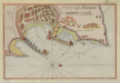 | Details | Roux, Joseph | 1764 |
| Antique chart of Rhodes, Greece |
|
Roux, Joseph |
|
| 1764 |
| LOC:2 |
| $185.00 | Roux--Joseph | Antique-chart-of-Rhodes--Greece | Antique nautical chart of the town and harbor of Rhodes on the island of Rhodes, Greece in the Aegean sea, close to the coast of Turkey.
<BR> </BR>
Original copperplate-engraved chart coverage by Joseph Roux includes the walled village of Rhodes, Casa Cornuta, and Rhodes harbor. The harbor and lighthouse, are shown as flanked by two jetties, each supporting a half-dozen windmills, and terminating offshore with a small fort or bastion. Numerous soundings and anchorages would have assisted 18th century mariners in navigating that area. <BR> </BR>
There were at least four small atlases of port and coastal charts that originated from Marseille hydrographers in the 18th century. Beginning in approximately 1727 these atlases included works by cartographers
<a rel="nofollow" href= "/MichelotBremondBackground.aspx"> Michelot and Bremond</a>,
<a rel="nofollow" href= "/Creator/Ayrouard--Jacques"> Jacques Ayrouard</a>,
<a rel="nofollow" href= "/Creator/Roux--Joseph"> Joseph Roux</a>
, and Jean Allezard. This small original chart is from the atlas of Mediterranean ports produced by Joseph Roux - "Recueil des Principaux Plans des Ports et Rades de la Mer Méditerranée". Plate 127. |
| 629 | 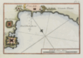 | Details | Roux, Joseph | 1764 |
| Antique harbor chart of Palma, Mallorca |
|
Roux, Joseph |
|
| 1764 |
| LOC:0 |
| $0.00 | Roux--Joseph | Antique-harbor-chart-of-Palma--Mallorca | SOLD
<BR> </BR>
Small and colorful mid 18th-century antique nautical chart of the harbor at Palma, Mallorca ( Majorca ), Spain. Coverage of this original copperplate-engraved harbor chart includes the walled village of Palma ( Palme ), the 'Tour de Lazaret' , Port Pin ( Porto Pi ), and the Vauban-style Fort de Port Pin. Several windmills are located as are soundings with suggested anchorages to aid early navigators unfamiliar with the area. Plate 8. <BR> </BR>
There were at least four small atlases of port and coastal charts that originated from Marseille hydrographers in the 18th century. Beginning in approximately 1727 these atlases included works by cartographers
<a rel="nofollow" href= "/MichelotBremondBackground.aspx"> Michelot and Bremond</a>,
<a rel="nofollow" href= "/Creator/Ayrouard--Jacques"> Jacques Ayrouard</a>,
<a rel="nofollow" href= "/Creator/Roux--Joseph"> Joseph Roux</a>
, and Jean Allezard. This small original chart is from the atlas of Mediterranean ports produced by Joseph Roux - "Recueil des Principaux Plans des Ports et Rades de la Mer Méditerranée". |
| 626 | 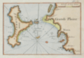 | Details | Roux, Joseph | 1764 |
| Ibiza and Formentera Spain |
|
Roux, Joseph |
|
| 1764 |
| LOC:4 |
| $190.00 | Roux--Joseph | Ibiza-and-Formentera-Spain | Antique engraved nautical chart of the harbor and town of Yvice ( Ibiza ) on the island of Ibiza, Spain. Coverage includes nearby Formentera ( Fromentiere ) Island.
<BR> </BR>
This small original chart is from the atlas of Mediterranean ports produced by Joseph Roux - "Recueil des Principaux Plans des Ports et Rades de la Mer Méditerranée".<BR> </BR>
There were at least four small atlases of port and coastal charts that originated from Marseille hydrographers in the 18th century. Beginning in approximately 1727 these atlases included works by cartographers
<a rel="nofollow" href= "/MichelotBremondBackground.aspx"> Michelot and Bremond</a>,
<a rel="nofollow" href= "/Creator/Ayrouard--Jacques"> Jacques Ayrouard</a>,
<a rel="nofollow" href= "/Creator/Roux--Joseph"> Joseph Roux</a>
, and Jean Allezard.
<br></br>
Comparison between Roux's chart and that of Michelot and Bremond shows that Roux copied Michelot's topography, anchorages, place names, and soundings directly from Michelot's chart that had been produced 40 years earlier. Plate 7. |
| 630 | 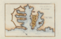 | Details | Roux, Joseph | 1764 |
| Plan of Valletta Malta by Joseph Roux |
|
Roux, Joseph |
|
| 1764 |
| LOC:4 |
| $385.00 | Roux--Joseph | Plan-of-Valletta-Malta-by-Joseph-Roux | Beautifully hand-colored mid 18th-century antique nautical chart and plan of Valetta, Malta ( Malthe ). Plate 75. <BR> </BR>
There were at least four small atlases of port and coastal charts that originated from Marseille hydrographers in the 18th century. Beginning in approximately 1727 these atlases included works by cartographers
<a rel="nofollow" href= "/MichelotBremondBackground.aspx"> Michelot and Bremond</a>,
<a rel="nofollow" href= "/Creator/Ayrouard--Jacques"> Jacques Ayrouard</a>,
<a rel="nofollow" href= "/Creator/Roux--Joseph"> Joseph Roux</a>
, and Jean Allezard. This small original chart is from the atlas of Mediterranean ports produced by Joseph Roux - "Recueil des Principaux Plans des Ports et Rades de la Mer Méditerranée". |
| 1094 | 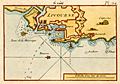 | Details | Roux, Joseph | 1780 |
| Roux antique port plan of Livorno, Italy |
|
Roux, Joseph |
|
| 1780 |
| LOC:4 |
| $165.00 | Roux--Joseph | Roux-antique-port-plan-of-Livorno--Italy | Attractive, antique nautical chart / port plan of the town and harbor of Livorno ("Livourne"), Italy on the Ligurian Sea, southwest of Pisa. Variant edition Plate 24 published from Livorno by Meucci in the "Recueil Des Principaux Plans des Ports et Rades de la Mer Méditerranée, Estraits de ma carte en Douze Feüilles Dediée à Mons. Le Duc de Choiseul Ministre de la guerre et de la Marine …" .
<BR> </BR>
Original copperplate-engraved nautical port plan with depth soundings by Joseph Roux includes the town of Livorno surrounded by double Vauban-style defensive walls; the darce, or interior shipping basin; the Capucine; a lighthouse or signal tower ("fanal"); the "Tours de la Marsoque"; and "Maison de Sante".
<BR> </BR>
Joseph Roux Sr. (1725-1793) was a French cartographer and hydrographer who lived in Marseille. The Roux family, with Roux's son Jospeh Jr. and grandson Antoine Roux, was involved in marine cartography and marine painting from Marseille into the mid-19th century. |
| 1093 | 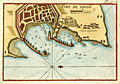 | Details | Roux, Joseph | 1780 |
| Roux antique plan of Rhodes, Greece |
|
Roux, Joseph |
|
| 1780 |
| LOC:2 |
| $225.00 | Roux--Joseph | Roux-antique-plan-of-Rhodes--Greece | Attractive, antique nautical chart / port plan of the town and harbor of Rhodes on the island of <b>Rhodes, Greece</b> in the Aegean sea, close to the coast of Turkey. Variant edition Plate 127A published in "Recueil Des Principaux Plans des Ports et Rades de la Mer Méditerranée, Estraits de ma carte en Douze Feüilles Dediée à Mons. Le Duc de Choiseul Ministre de la guerre et de la Marine …" from Livorno by Meucci.
<BR> </BR>
Original copperplate-engraved chart by Joseph Roux includes the walled village of Rhodes, Casa Cornuta, and Rhodes harbor. The harbor and lighthouse, are shown as flanked by two jetties, each supporting a half-dozen windmills, and terminating offshore with a small fort or bastion. Numerous soundings and anchorages would have assisted 18th century mariners in navigating that area.
<BR> </BR>
Joseph Roux Sr. (1725-1793) was a French cartographer and hydrographer who lived in Marseille. The Roux family, with Roux's son Jospeh Jr. and grandson Antoine Roux, was involved in marine cartography and marine painting from Marseille into the mid-19th century. |
| 1438 | 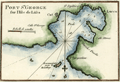 | Details | Roux, Joseph | 1780 |
| Roux antique plan of Vis (Lucca) harbor in Croatia |
|
Roux, Joseph |
|
| 1780 |
| LOC:2 |
| $125.00 | Roux--Joseph | Roux-antique-plan-of-Vis-(Lucca)-harbor-in-Croatia | Attractive, antique nautical chart / port plan of the town and harbor on the island of Vis, Croatia, ("Lissa") off the Dalmatian Coast, in the Adriatic Sea. Vis is furthest island in the Adriatic from the Croatian coast and lies southwest of the islands of Hvar, Brac and Solta.
<BR> </BR>
The port of Vis is identified by Roux as "Lucca". Other key features on this port plan include "Cut", "St. Spilice", "Calle St. George", "Calle Stance", and "Pointe Argentine". On the small and high offshore island of Otočić Host, Roux notes a "Reconnaissance pour le Mouillage" or a place to view the anchorage at Vis.
<BR> </BR>
For many years Vis was the military and naval headquarters of Tito’s partisan army and was closed to the public until 1989. This meant that it largely escaped commercial development and has been able to retain its natural beauty. Plate 85.
<BR> </BR>
Joseph Roux Sr. (1725-1793) was a French cartographer and hydrographer who lived in Marseille. The Roux family, with Roux's son Jospeh Jr. and grandson Antoine Roux, was involved in marine cartography and marine painting from Marseille into the mid-19th century. |
| 1127 | 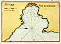 | Details | Roux, Joseph | 1790 |
| Antique harbor plan of Çesme , Turkey |
|
Roux, Joseph |
|
| 1790 |
| LOC:2 |
| $160.00 | Roux--Joseph | Antique-harbor-plan-of-Çesme---Turkey | Antique nautical chart or port plan of the environs around the Bay and village of Çeşme ( Chesme ) Turkey at the far west end of Anatolia near the Çeşme Peninsula. Interestingly, the character "N" in the title "Natolie" is engraved backwards. Çeşme Castle, a 500 year old Ottoman fort is depicted as a walled compound and dominates the east end of the bay. The castle, renovated after the Ottoman-Russian War in 1770, was not used for military purposes after the Crimean War. The castle is is now the Çeşme Archeology Museum.
<BR> </BR>
Çeşme lies in Izmir Province about 50 miles west of the city of Izmir and across a narrow strait from the Greek island of Chios. Çeşme is known as the windsurfing and kite-surfing capital of Turkey, and is considered among the best surfing areas in the world. A few small islands or sandbars, and depth soundings are shown on the map, along with a grove of trees on the north side of the bay.
<BR> </BR>
This small original chart is from a late 18th century edition of the atlas of Mediterranean ports produced by Joseph Roux - "Recueil des Principaux Plans des Ports et Rades de la Mer Méditerranée". Plate 144A.
<BR> </BR>
There were at least four small atlases of port and coastal charts that originated from Marseille hydrographers in the 18th century. Beginning in approximately 1727 these atlases included works by cartographers :
<a rel="nofollow" href= "/MichelotBremondBackground.aspx"> Michelot and Bremond</a>,
<a rel="nofollow" href= "/Creator/Ayrouard--Jacques"> Jacques Ayrouard</a>,
<a rel="nofollow" href= "/Creator/Roux--Joseph"> Joseph Roux</a>
, and Jean Allezard. |