| | Thumbnail | | Creator | Date | Title / Author / Date / Location | Price | | | Description |
| 6337 | 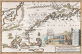 | Details | Aa, Pieter van der | 1707 |
| Nieuw Engeland in Twee Scheeptogten door Kapitein Johan Smith inde iaren 1614 en 1615 Bestevend |
|
Aa, Pieter van der |
|
| 1707 |
| LOC:78 |
| $1,000.00 | Aa--Pieter-van-der | Nieuw-Engeland-in-Twee-Scheeptogten-door-Kapitein-Johan-Smith-inde-iaren-1614-en-1615-Bestevend | Scarce map of New England, Cape Cod, Nantucket and more after John Smith. "Nieuw Engeland in Twee Scheeptogen door Kapitein Johan Smith inde iaren 1614 en 1615 bestevend". (New England as Described by Captain John Smith in two voyages in 1614 and 1615. By Pieter van der Aa, a Dutch mapmaker and publisher.
<br></br> |
| 1116 | 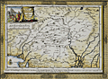 | Details | Aa, Pieter van der | 1713 |
| Antique map of North India or The Empire of the Grand Mogol |
|
Aa, Pieter van der |
|
| 1713 |
| LOC:6 |
| $250.00 | Aa--Pieter-van-der | Antique-map-of-North-India-or-The-Empire-of-the-Grand-Mogol | Attractive antique map by Peter van der Aa of India, the Empire of the Grand Mogol, with the frontiers of Persia and Tartary after the memoires of Nuno de Cunha . Nunho de Cunha, the son of famed Portugese explorer Tristão da Cunha, was the ninth governor of Portuguese possessions in India from 1528 to 1538.
<br></br>
Extends across northern India with parts of Pakistan and Afghanistan. Includes the Indian states of Gujarat ("Guzaratte"), Rajasthan, Madhya Pradesh, and Haryana as well as numerous tributaries to the Ganges and Indus rivers. Key cites noted on the map include Dehli ("Deli"), Ahmedabad ("Hamedebat"), Kabul ("Cabul"), Lahore, Attock, Parvan, Campion, Pitan and numerous others. The map is printed into a finely-engraved decorative frame and will make a handsome presentation when framed.
<br></br>
Pieter van der Aa (1659 - 1733) was a Dutch publisher working in Leiden during the early eighteenth century. He is best known for publishing maps and atlases, though he also printed pirated editions of foreign bestsellers and illustrated volumes. Van de AA's use of stock mock-frame borders is a characteristic for which he is well known. This map shows evidence of two plate marks, one for the mock-frame and the second interior platemark for the smaller map which was printed inside the mock-frame. From "Le nouveau theatre du monde. ou La geographie royale, composée de nouvelles cartes tres-exactes", published from Leiden in 1713. |
| 1118 | 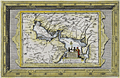 | Details | Aa, Pieter van der | 1713 |
| Antique Dutch Map of the Persian Gulf region |
|
Aa, Pieter van der |
|
| 1713 |
| LOC:0 |
| $0.00 | Aa--Pieter-van-der | Antique-Dutch-Map-of-the-Persian-Gulf-region | SOLD<br></br>
Beautiful intaglio-printed antique map by Peter van der Aa of the Persian Gulf region incorporating portions of present-day Saudi Arabia, Iran, Iraq, India, Bahrain ("Baharem"), Qatar ("Queximi"), Oman, Ormuz, and Kuwait. Key cities va der AA identified by name include: Mecca ("Mecha") , Medina ("Medina t Alnabi"), Basrah ("Bassora"), Muscat ("Mascate"), Ahmedabad ("Hamedebat"), and Khambhat ("Cambaya").
<br></br>
This fine map will make a handsome presentation when framed. An attractive cartouche with European ships in the background shows a local merchant negotiating with two dark, shirtless natives carrying a spear.
<br></br>
Pieter van der Aa (1659 - 1733) was a Dutch publisher working in Leiden during the early eighteenth century. He is best known for publishing maps and atlases, though he also printed pirated editions of foreign bestsellers and illustrated volumes. Van de AA's use of stock mock-frame borders is a characteristic for which he is well known. This map shows evidence of two plate marks, one for the mock-frame and the second interior platemark for the smaller map which was printed inside the mock-frame. From "Le nouveau theatre du monde. ou La geographie royale, composée de nouvelles cartes tres-exactes", published from Leiden in 1713. |
| 1380 | 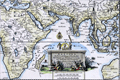 | Details | Aa, Pieter van der | 1713 |
| Antique framed map of Indian Ocean, Asia, Australia |
|
Aa, Pieter van der |
|
| 1713 |
| LOC:0 |
| $0.00 | Aa--Pieter-van-der | Antique-framed-map-of-Indian-Ocean--Asia--Australia | SOLD<br></br>
Very attractive copper-engraved antique map by Pieter van der Aa of Asia, Africa, Madagascar Java, Saudi Arabia, Philippines, western Australia, and much more. Matted and framed measures 17" x 13". Map itself, ca. 1713 within an elaborate and decorative printed border. Based on the voyage of Nuno de Cunha.
<br></br>
This beautiful old map with a fine title cartouche covers the Mediterranean Sea, the Red Sea, Persian Gulf, Arabian Sea, Gulf of Bengal, and the South China Sea.
<br></br>
Pieter van der Aa (1659 - 1733) was a Dutch publisher working in Leiden during the early eighteenth century. He is best known for publishing maps and atlases, though he also printed pirated editions of foreign bestsellers and illustrated volumes. Van de AA's use of stock mock-frame borders is a characteristic for which he is well known. The map shows evidence of two plate marks, one for the mock-frame and the second interior platemark for the smaller map which was printed inside the mock-frame. From "Le nouveau theatre du monde. ou La geographie royale, composée de nouvelles cartes tres-exactes", published from Leiden in 1713. |
| 1381 | 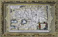 | Details | Aa, Pieter van der | 1713 |
| Fine antique framed map of Tartary or north central Asia |
|
Aa, Pieter van der |
|
| 1713 |
| LOC:0 |
| $240.00 | Aa--Pieter-van-der | Fine-antique-framed-map-of-Tartary-or-north-central-Asia | Matted and framed…
<br></br>
Attractive, framed copper-engraved antique map of Tartary by Pieter van der Aa. The name "Tartary" was used until the twentieth century to designate the great tract of northern and central Asia stretching from the Caspian Sea and the Ural Mountains to the Pacific Ocean. Tartary consisted of the high plateau of central Asia and its north-western slopes, which formed part of the Tartar empire in the Middle Ages.
<br></br>
Includes the Black Sea ("Pontus Euxinus"), Caspian Sea ("Mare Caspium") and western Mediterranean Sea ("Mare Mediterraneum"). Covers parts or all of modern-day Turkey, Iran, Georgia, Azerbaijan, Syria, Iraq, China, Nepal, and Afghanistan.
<br></br>
Matted and framed measures 17" x 13". Map itself, ca. 1713 within an elaborate and decorative printed border.
<br></br>
Pieter van der Aa (1659 - 1733) was a Dutch publisher working in Leiden during the early eighteenth century. He is best known for publishing maps and atlases, though he also printed pirated editions of foreign bestsellers and illustrated volumes. Van de AA's use of stock mock-frame borders is a characteristic for which he is well known. The map shows evidence of two plate marks, one for the mock-frame and the second interior platemark for the smaller map which was printed inside the mock-frame. From "Le nouveau theatre du monde. ou La geographie royale, composée de nouvelles cartes tres-exactes", published from Leiden in 1713. |
| 1186 | 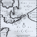 | Details | Aa, Pieter van der | 1719 |
| Scarce Antique Map of Hokkaido, Japan |
|
Aa, Pieter van der |
|
| 1719 |
| LOC:9 |
| $600.00 | Aa--Pieter-van-der | Scarce-Antique-Map-of-Hokkaido--Japan | Antique Dutch map of the island of Eso, today called Hokkaido, the northernmost of Japan's main islands. Printed on a large sheet measuring 19" W x 15" H.
<br></br>
Pieter van der Aa (1659 - 1733) was a Dutch publisher working in Leiden during the early eighteenth century. He is best known for publishing maps and atlases, though he also printed pirated editions of foreign bestsellers and illustrated volumes. From "Nouvel atlas...contenant les principales cartes géographiques dressées suivant les nouvelles observations de Mr. de l'Académie royale des sciences" published in 1714 from Leiden by Van der Aa. Plate number 27 (in manuscript). |
| 1187 | 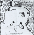 | Details | Aa, Pieter van der | 1719 |
| Scarce Antique Map of Banten in Java Indonesia |
|
Aa, Pieter van der |
|
| 1719 |
| LOC:9 |
| $300.00 | Aa--Pieter-van-der | Scarce-Antique-Map-of-Banten-in-Java-Indonesia | Antique Dutch map of the bay and village of "Bantam" or Banten, Java. Includes a plan of Bantam, and the smaller islands of Pulau Panjang, Groot P. Moby, Poele Don, Cleyn P. Moby, and Hollands kerk-hof. On a much larger sheet of watermarked (with fleur-de-lis), chain laid paper measuring 19" W x 15" H.
<br></br>
Pieter van der Aa (1659 - 1733) was a Dutch publisher working in Leiden during the early eighteenth century. He is best known for publishing maps and atlases, though he also printed pirated editions of foreign bestsellers and illustrated volumes. From "Nouvel atlas...contenant les principales cartes géographiques dressées suivant les nouvelles observations de Mr. de l'Académie royale des sciences" published in 1714 from Leiden by Van der Aa. Plate number 19 (in manuscript). |
| 1191 | 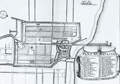 | Details | Aa, Pieter van der | 1719 |
| Antique City Plan of Batavia or Jakarta, Indonesia |
|
Aa, Pieter van der |
|
| 1719 |
| LOC:9 |
| $365.00 | Aa--Pieter-van-der | Antique-City-Plan-of-Batavia-or-Jakarta--Indonesia | Antique Dutch map of the village of "Batavia" or Jakarta, Indonesia. Jakarta was the de facto capital of the Dutch East Indies, formed from the nationalized colonies of the Dutch East India Company (VOC), which came under the administration of the Dutch government in 1800.
<br></br>
Forty-one notable locations are identified numerically on this fine copper-plate engraved plan and are explained in a large table at bottom right. These important locations include defensive positions, churches, and maritime related sites such as:
<div class="indenttextblock">
<ul style="list-style-type: circle;">
<li>le Fort</li>
<li>Redoute d' Amsterdam</li>
<li>Bastion le Saphir</li>
<li>Reduit de Nassau</li>
<li>le Werf Place aux Ancres</li>
<li>Grande Riviere</li>
<li>le Canal</li>
<li>l'Eglise des Portugais</li>
<li>Marche au poissons</li>
<li>le Hospital</li>
</ul>
</div>
On a much larger sheet of antique chain-laid paper measuring 19" W x 15" H.
<br></br>
Pieter van der Aa (1659 - 1733) was a Dutch publisher working in Leiden during the early eighteenth century. He is best known for publishing maps and atlases, though he also printed pirated editions of foreign bestsellers and illustrated volumes. From "Nouvel atlas...contenant les principales cartes géographiques dressées suivant les nouvelles observations de Mr. de l'Académie royale des sciences" published in 1714 from Leiden by Van der Aa. Plate number or notation in manuscript at bottom left. |
| 1177 | 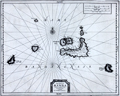 | Details | Aa, Pieter van der | 1719 |
| Antique map of the Banda Islands, Indonesia |
|
Aa, Pieter van der |
|
| 1719 |
| LOC:9 |
| $880.00 | Aa--Pieter-van-der | Antique-map-of-the-Banda-Islands--Indonesia | Rare Dutch map / chart of the Banda Islands, part of the Indonesian province of Maluku, comprising the important Spice Islands. The Banda Islands are part of the Moluccas archipelago to the west of New Guinea. Until the mid-19th century the Banda Islands were the world's only source of the spices nutmeg and mace, produced from the nutmeg tree.
<br></br>
Pieter van der Aa (1659 - 1733) was a Dutch publisher working in Leiden during the early eighteenth century. He is best known for publishing maps and atlases, though he also printed pirated editions of foreign bestsellers and illustrated volumes. From "Nouvel atlas...contenant les principales cartes géographiques dressées suivant les nouvelles observations de Mr. de l'Académie royale des sciences" published in 1714 from Leiden by Van der Aa. Plate number 27 (in manuscript).
<br></br>
Printed on a large sheet measuring 19" W x 15" H. |
| 1185 | 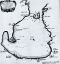 | Details | Aa, Pieter van der | 1719 |
| Bay of Manilla, Philippines Islands |
|
Aa, Pieter van der |
|
| 1719 |
| LOC:0 |
| $0.00 | Aa--Pieter-van-der | Bay-of-Manilla--Philippines-Islands | SOLD<br></br>
Rare Dutch map / chart of the Bay of Manilla, in the Philippine Islands. "De Stadt Manilha" is shown as a cluster of houses and churches. Details provided about depth soundings, and the relative location of rivers, habitations, and churches suggest that this small chart may have had its origin in a working nautical chart.
<br></br>
Pieter van der Aa (1659 - 1733) was a Dutch publisher working in Leiden during the early eighteenth century. He is best known for publishing maps and atlases, though he also printed pirated editions of foreign bestsellers and illustrated volumes. From "Nouvel atlas...contenant les principales cartes géographiques dressées suivant les nouvelles observations de Mr. de l'Académie royale des sciences" published in 1714 from Leiden by Van der Aa. Plate number 27 (in manuscript).
<br></br>
Printed on a large sheet measuring 19" W x 15" H. |
| 1433 | 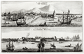 | Details | Aa, Pieter van der | 1725 |
| Scarce antique views of Batavia or Jakarta, Indonesia |
|
Aa, Pieter van der |
|
| 1725 |
| LOC:9 |
| $500.00 | Aa--Pieter-van-der | Scarce-antique-views-of-Batavia-or-Jakarta--Indonesia | Two fine antique copperplate-engraved views of Batavia (Jakarta, Indonesia), capital of the Dutch East Indies. One early view "La Ville de Batavie" with city structures in the background, shows the shallow channel to the inner harbor marked by pilings, with shallow-draft vessels plying the waters. Further off-shore deeper-draft, square-rigged sailing ships are drawn at anchor and tied to tall above-water structures we today would describe as pilings with cribbing. Excellent quality engravings.
<br></br>
The second view "Chateau de Batavia" presents a square-shaped fortress equipped with four protruding bastions made of solid earthen walls and coral with a strong wooden palisade. Batavia Castle was the administrative center of the Dutch East India Company (VOC) in Asia. Batavia Castle housed the administration buildings of the VOC, including the Governor-General's residence, residences for high officials, workshops, a treasury, a prison, storehouses and the meeting hall of the council of the Indies.
<br></br>
Batavia corresponds to the present city of Jakarta, Indonesia. Batavia was founded as the trade and administrative center of the Dutch East India Company and within Batavia's walls, the wealthy Dutch built tall houses and canals.
<br></br>
Published from Leiden by Pieter van der Aa.
<br></br>
Pieter van der Aa (1659 - 1733) was a Dutch publisher working in Leiden during the early eighteenth century. He is best known for publishing maps and atlases, though he also printed pirated editions of foreign bestsellers and illustrated volumes. From "La Galerie Agreable du Monde. Tome premier des Indes Orientales" published in 1725 from Leiden by Van der Aa. This plate was originally published in 'Gezandtschap der Nederlandtsche Oost-Indische Compagnie ...' by J. Nieuhof. |
| 1474 | 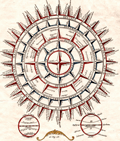 | Details | Aa, Pieter van der | 1729 |
| Philippi Brietii S.J. Ventorum Tabula |
|
Aa, Pieter van der |
|
| 1729 |
| LOC:200 |
| $180.00 | Aa--Pieter-van-der | Philippi-Brietii-S-J--Ventorum-Tabula | Decorative hand-colored engraving of a wind-rose. A wonderful piece that illustrates the ability of graphics to convey information about our earth.
<br></br>
The wind-rose is subdivided into five categories. First, "Divisio & Nomina Ventorum Apud Nautis" reads as "The winds divided and named according to navigators' .It uses an unusual and complicated wind rose to illustrate the directions and names of the best known winds around the world. Included are such names as 'Levante', 'Sirocco', 'Ponante', 'Transmontana' and 'Ostro vel Mezo Giorno'.
<br></br>
Antique engraving in Philip Cluver's magnum opus 'Introductionis in Universam Geographiam', a well-known geography textbook issued in various editions for many years beginning in 1624.
<br></br>
This very attractive engraving comes from a 1729 edition of 'Introductionis..' |
| 1019 | 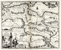 | Details | Aa, Pieter van der | 1730 |
| North Africa Barbarie, Biledulgerid and Libye |
|
Aa, Pieter van der |
|
| 1730 |
| LOC:50 |
| $300.00 | Aa--Pieter-van-der | North-Africa-Barbarie--Biledulgerid-and-Libye | Uncommon, beautifully engraved map of North Africa and the southern Mediterranean Sea by Peter van der Aa. A fine example.
<br></br>
Attractive cartouche with scene of galleys and wild animals, representative of Africa. Includes the southern Mediterranean Sea with Crete and the southern Aegean Archipelago.
<br></br>
Published from Leiden ca 1730 by Covens and Mortier. |