| | Thumbnail | | Creator | Date | Title / Author / Date / Location | Price | | | Description |
| 4728 | 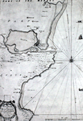 | Details | Adair, John | 1693 |
| Very Rare Antique Chart of Montrose, Angus, Scotland |
|
Adair, John |
|
| 1693 |
| LOC:88 |
| $1,950.00 | Adair--John | Very-Rare-Antique-Chart-of-Montrose--Angus--Scotland | Original antique navigation chart of Montrose (Montross), Scotland by civilian marine surveyor and cartographer John Adair (1655 - 1722). Maps by Adair seldom are found for sale.
<br></br>
Adair was the foremost surveyor of Scotland in the late 1600s, and was appointed to conduct a hydrographical survey of the Scottish coast by a special act of Scottish Parliament to be funded by a tax on vessels entering Scottish ports. The tax proved unpopular and Adair's survey was underfunded and slow in progress. Thus, this chart, engraved in 1693, was not printed until 10 years later in 1703.
<br></br>
Montrose lies along the eastern coast of Scotland about 50 miles north of Dundee. The chart includes small images of local fishing vessels.
<br></br>
This rare chart of the Scottish coast, although compiled and engraved in 1693, was published in 1703 along with 5 other charts in Adair's rare sea atlas "The Description of the Sea- Coast and Islands of Scotland With Large and Exact Maps, for the Use of Seamen" [1]. These other charts in Adair's atlas are titled as below:
<div class="indenttextblock">
1) General chart of Scotland made on a voyage by James the Fifth.</BR>
2) St. Abb's Head to Sunderland Point.</BR>
3) Firth of Forth.</BR>
4) Frith and River Tay.</BR>
5) Red Head to Aberdeen including Montrose.</BR>
</div>
</BR>
The AMPR shows no record of this chart sold individually and records only one copy of Adair's atlas sold (2010).
<br></br>
[1] Robinson, A.H.W. 'Marine Cartography in Britain'. Leicester University Press. 1962. pp. 162; . |