| | Thumbnail | | Creator | Date | Title / Author / Date / Location | Price | | | Description |
| 4944 | 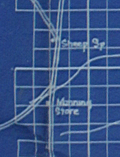 | Details | Adams Engineering Company | 1920 |
| Wildcatters oil-field prospect map for San Juan County, New Mexico |
|
Adams Engineering Company |
|
| 1920 |
| LOC:62 |
| $300.00 | Adams-Engineering-Company | Wildcatters-oil-field-prospect-map-for-San-Juan-County--New-Mexico | Wildcatter's blueprint (cyanotype) oil-field prospect map ca. 1920 for San Juan County, New Mexico. Four corners region near Aztec, Farmington, Shiprock and the Navajo Indian Reservation. The blueprint shows existing and proposed oil wells and oil field leases owned by an anonymous individual or company, annotated with typewritten notes:
<br></br>
"Midwest Oil Co. pool on the Hog Back they just … the 7th well at 690 feet they found sand … this is the most wonderful oil field in the world."
<br></br>
"U.S. Geological Survey of 1916 Professional paper 98-P of the San Juan … I looked this country over carefully for 5 months at the same time trying to get rid of my Rheumatism and [in my] my opinion it will only take development to have an oil field where I have my leases marked in red on this map."
<br></br>
My interpretation of the maps and notes are that the purpose of the map was to persuade investors to invest in the leases marked in red squares (at furthest right center) by reference to other known, producing oil wells (marked with small red dots).
Published by Adams Engineering Company, Oklahoma City, Oklahoma. Drawn by H. Marsh. |