| | Thumbnail | | Creator | Date | Title / Author / Date / Location | Price | | | Description |
| 1058 | 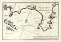 | Details | Allezard, Jean Joseph | 1804 |
| Early French Port Plan of Cannes and Antibes France |
|
Allezard, Jean Joseph |
|
| 1804 |
| LOC:4 |
| $150.00 | Allezard--Jean-Joseph | Early-French-Port-Plan-of-Cannes-and-Antibes-France | Small antique port plan of a portion of the Côte d'Azur on the Mediterranean coast of southeatern France. Coverage includes Cannes and Cap d'Antibes, the peninsula between the Bay of Cannes to the south-west and the Baie des Anges to the north east.
<br></br>
Plate 20 of Allezard's atlas "Recueil de 163 des principaux Plans des Ports et Rades de la Mediterranée, dont 40 ont été derniérement publiés par Jean Joseph Allezard ancien Capitaine de Marine." Essentially this plan is a later copy of a plan first laid down by Michelot and Bremond around 1727 and later published by Roux. |
| 1032 | 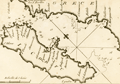 | Details | Allezard, Jean Joseph | 1811 |
| Chart of Corfu by Allezard |
|
Allezard, Jean Joseph |
|
| 1811 |
| LOC:2 |
| $165.00 | Allezard--Jean-Joseph | Chart-of-Corfu-by-Allezard | Antique chart / plan of the Ionian island of Corfu, Greece, the second largest of the Ionian islands. Includes a portion of the west coast of mainland Greece.
<br></br>
Very interesting note by Allezard at the far northwest of the mainland: "Cent quarante les 3 ecolles". Turns out that the area is Sarande, Albania and that the note is a reference to a Byzantine monastery "the Forty Saints" , honoring the "Forty Martyrs of Sebaste" leading to the Italian name "Santi Quaranta" which Allezard spelled phonetically "Cent Quarante".
<br></br>
One of 163 plates of ports on the Mediterranean, Adriatic and Black seas from Allezard's atlas "Recueil de 163 des principaux plans des ports et rades de la Mediterranée, dont 40 ont été derniérement publiés par Jean Joseph Allezard ancien capitaine de marine et plusieurs des autres corrigés" . This atlas was a re-issue of Joseph Roux's atlas published from Marseille in several editions beginning in 1764. Published by Joseph Gamba from Livorno, Italy. Plate 49. |
| 865 |  | Details | Allezard, Jean Joseph | 1817 |
| Antique nautical plan of Venice, Italy and lagoons |
|
Allezard, Jean Joseph |
|
| 1817 |
| LOC:4 |
| $175.00 | Allezard--Jean-Joseph | Antique-nautical-plan-of-Venice--Italy-and-lagoons | Antique harbor plan of Venice, Italy and its nearby islands, canals, and villages. The copperplate-engraved map extends from Chioggia ( "Chiozza" ) in the south past the islands of Lido and Malamocco. Venice is shown as an archipelago of about 30 inhabited islands in the center of the lagoon. Some of the noted towns and villages surrounding Venice include Ville Franche, Termine, Palestrina, Bolta, St. Ange, St. George, Muran ( Murano ), Vignole, Neuveau Lazaret, and St. Francis du Desert. Soundings and navigational aids are absent from this small nautical chart. The primary man-made feature of note is the hospital at the east of Venice.
<br></br>
One of 163 plates of ports on the Mediterranean, Adriatic and Black seas from Allezard's atlas "Recueil de 163 des principaux plans des ports et rades de la Mediterranée, dont 40 ont été derniérement publiés par Jean Joseph Allezard ancien capitaine de marine et plusieurs des autres corrigés" . This atlas was a re-issue of Joseph Roux's atlas published from Marseille in several editions beginning in 1764. Published by Joseph Gamba from Livorno, Italy. Plate 81. |
| 866 | 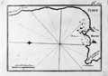 | Details | Allezard, Jean Joseph | 1817 |
| Antique nautical chart of Beirut, Lebanon and approaches |
|
Allezard, Jean Joseph |
|
| 1817 |
| LOC:4 |
| $135.00 | Allezard--Jean-Joseph | Antique-nautical-chart-of-Beirut--Lebanon-and-approaches | Antique maritime chart of the area around and including Beirut, Lebanon, then considered part of Syria ( "Syrie" ). This old copperplate-engraved map extends from Cape Danthon to the east past Beirut and then follows the coast northward until approximately the town of Juniyah. A few soundings and anchorages are defined. Sea charts of ports on the Levantine coast of the Eastern Mediterranean from this time period are somewhat scarce.
<br></br>
One of 163 plates of ports on the Mediterranean, Adriatic and Black seas from Allezard's atlas "Recueil de 163 des principaux plans des ports et rades de la Mediterranée, dont 40 ont été derniérement publiés par Jean Joseph Allezard ancien capitaine de marine et plusieurs des autres corrigés" . This atlas was a re-issue of Joseph Roux's atlas published from Marseille in several editions beginning in 1764. Published by Joseph Gamba from Livorno, Italy. Plate 119. |
| 1030 | 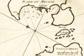 | Details | Allezard, Jean Joseph | 1817 |
| Antique chart of Mykonos, Greece |
|
Allezard, Jean Joseph |
|
| 1817 |
| LOC:2 |
| $145.00 | Allezard--Jean-Joseph | Antique-chart-of-Mykonos--Greece | Antique chart / plan of the Aegean island of Mikonos / Mykonos, Greece along with the northwestern portion of Delos, famous for its important archeological site and in mythology the birthplace of the twin gods Apollo and Artemis. Maps shows the village of Mykonos and a single building off in the distance labeled "Calori".
<br></br>
One of 163 plates of ports on the Mediterranean, Adriatic and Black seas from Allezard's atlas "Recueil de 163 des principaux plans des ports et rades de la Mediterranée, dont 40 ont été derniérement publiés par Jean Joseph Allezard ancien capitaine de marine et plusieurs des autres corrigés" . This atlas was a re-issue of Joseph Roux's atlas published from Marseille in several editions beginning in 1764. Published by Joseph Gamba from Livorno, Italy. Plate 141. |