| | Thumbnail | | Creator | Date | Title / Author / Date / Location | Price | | | Description |
| 4733 | 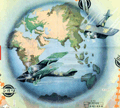 | Details | Asahi Shimbun | 1926 |
| Fine Japanese inter war sugoroku biplane flight game board |
|
Asahi Shimbun |
|
| 1926 |
| LOC:0 |
| $165.00 | Asahi-Shimbun | Fine-Japanese-inter-war-sugoroku-biplane-flight-game-board | Very attractive and decorative Japanese Taisho period inter-war sugoroku board game with pictures of biplanes. This large sugoroku commemorates a record long flight to Europe in July 1925 via the route of Tokyo-Paris-London. The flight, with two Breguet 19 A2 biplanes, was sponsored by the Asahi Shimbun newspaper and piloted by H. Abe and K. Kawachi, covering 13,800 km (8,575 mi).
<div class="indenttextblock">
The Bréguet XIX was two-seater light bomber and as a reconnaissance aircraft, first rolled out in 1923. A very successful metal biplane, it stayed in operational service for fifteen years.
(Source Online: http://acepilots.com/pioneer/breguet19.html)
</div>
</BR>
Set across a background of Asia, locations on the board correspond to cities in Asia and Europe to include Rome, London, Paris, Istanbul and many more. Text in Japanese. Verso is blank.
<br></br>
E-sugoroku, with rules similar to the game of chutes and ladders, appeared in Japan as late 13th century and became popular due to the cheap and elaborate wooden block printing technology of the Edo period. Sugoroku boards were made with pictures and themes from religion, political, actors, heroes, and popular culture. |
| 6742 |  | Details | Asahi Shimbun | 1942 |
| Japanese map of Singapore printed the day Britain capitulated |
|
Asahi Shimbun |
|
| 1942 |
| LOC:6 |
| $400.00 | Asahi-Shimbun | Japanese-map-of-Singapore-printed-the-day-Britain-capitulated | Interesting Japanese maps of the Malaysian Peninsula and Singapore, Malaysia printed on February 15, 1942 (Showa 17).
<br><br>
<div id="0" align="center">
<a title=""></a>
<img id="6742" src="/ZoomifyImages/SC_6742/SC_6742_detail.jpg" alt="Japanese map of Singapore published the day Britain capitulated to Japan in February, 1942." width="340"/> <br><br> <font size="-2">Japanese Map of Singapore. 1942. (6.5" x 4.5")</font>
</div><br>
Maps and text related to Malaysian history, terrain and climate, natural resources, population, and administration. Smaller map of Singapore contains information related to fortifications, broadcast towers, airfields, and oil storage facilities.
<br><br>
<div class="indenttextblocksingle">
Translation (partial): "In 1824 Singapore reached the southern coast of the island of Singapore, which the Englishman Raffles purchased from the King of Johor for $600,000. With a population of 600,000, it is the base of the British East Asian Fleet, along with Malacca in the Strait of Malacca and Jiyoji Town on Penang Island, and is the <b>cornerstone of world shipping that connects the Pacific Ocean and the Indian Ocean.</b>"
</div>
<br>
February 15, 1942, was a significant day during World War II as it marked the fall of Singapore to the Japanese forces. Singapore, then a British colony, was considered a crucial strategic stronghold in Southeast Asia. On that day, Japanese troops launched a major assault on Singapore, breaching the defensive lines and rapidly advancing. The British and Commonwealth forces, vastly outnumbered and lacking in supplies and reinforcements, were unable to hold back the Japanese onslaught.
<br><br>
Printed by Seiko Printing Co., Ltd. For Asahi Shimbun, Japan Publishing Culture Association Member Number 101503B. (1) |