| | Thumbnail | | Creator | Date | Title / Author / Date / Location | Price | | | Description |
| 3666 | 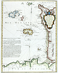 | Details | Avery, Joseph | 1779 |
| Rare chart of the Channel Islands after Joseph Avery |
|
Avery, Joseph |
|
| 1779 |
| LOC:57 |
| $4,200.00 | Avery--Joseph | Rare-chart-of-the-Channel-Islands-after-Joseph-Avery | Unrecorded French chart of Îles de la Manche in the English Channel- the Normandy coast and Channel Islands after the survey of Joseph Avery. Islands include Alderney, Guernsey, Jersey, Herm, and Sark.
<br></br>
Though similar to Beaurain's chart of 1757, no copy of this very attractive work after Avery is found online nor in AMPR. No copy of Avery's own original survey is found anywhere but his work should be dated between 1721 and 1742.
<br></br>
Joseph Avery was born in Scotland and is known to have charted the southern coast of England ca. 1721 and to have published a "well approved" map of that work. Avery emigrated to Charleston, SC where he worked as a ship builder and was hired in 1742 as surveyor to the Georgia province. (Cadle, Farris W. Georgia Land Surveying History and Law. University of Georgia Press. 1991. Pages 4-26)
<br></br>
J.F.W. DeBarres chart of the Coast Rivers and Inlets of the Province of Georgia (1780) is credited to be after the work of Joseph Avery and others. |