| | Thumbnail | | Creator | Date | Title / Author / Date / Location | Price | | | Description |
| 5031 | 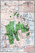 | Details | Bates, Waldron and others | 1922 |
| Path Map of the Eastern Part of Mount Desert Island, Maine |
|
Bates, Waldron and others |
|
| 1922 |
| LOC:53 |
| $0.00 | Bates--Waldron-and-others | Path-Map-of-the-Eastern-Part-of-Mount-Desert-Island--Maine | SOLD<br></br>Scarce map of the eastern portion of Mount Desert Island by Waldon Bates, Edward Rand, and Herbert Jaques after the U.S. Coast Survey. In 1922 Acadia National Park (in green) was known as Lafayette National Park. Includes coastal areas of Mount Desert Island on Frenchman's Bay and Somes Sound.
<br></br>
Waldron Bates began exploring Mount Desert Island in the 1880's. From 1900 to 1909, Bates was chairman of the Path Committee of the Bar Harbor Village Improvement Association (VIA). VIA's in each of the four island towns created most of the Mount Desert Island's trail system we know today, adding twenty-five miles of trails under Bate's leadership, including the Giant Slide, Canon Brook, Gorham Mountain, and Cadillac Cliffs Trails. (Source: https://www.nps.gov/acad/learn/historyculture/waldron-bates-pathmaker.htm)
<br></br>
Bates is well-known for the Bates cairn, a rock-constructed trail indicator which he designed:
<div class="indenttextblocksingle">
"The cairns are built on two base columns of between 2 and 4 rocks, with a lintel stone, or platform, across the two columns and a pointer rock on top. The cairns help orient hikers and steer them in the right direction, while protecting the environment by keeping people on the trail." Over times the Bates cairns suffered damage from human or environmental forces. Starting in 2001, an effort began to rebuild the cairns and to educate the public about their design and importance." (Source: https://acadiaonmymind.com/2016/01/message-rocks-acadia-bates-cairns-new-focus/) </div> |