| | Thumbnail | | Creator | Date | Title / Author / Date / Location | Price | | | Description |
| 4841 | 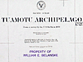 | Details | Belanske, William E. | 1930 |
| Charts related to Vanderbilts circumnavigation in 1930 Belanske |
|
Belanske, William E. |
|
| 1930 |
| LOC:300 |
| $0.00 | Belanske--William-E- | Charts-related-to-Vanderbilts-circumnavigation-in-1930-Belanske | SOLD<br><br>One lot of six (6) charts, each well-marked recto and verso with blue ink stamps of William E. Belanske, two with MS annotations. Belanske was an artist and former curator of William K. Vanderbilt's Marine Museum on his estate near Centerport, Long Island. These charts are related to the 1931 - 1932 circumnavigation of the world by William K. Vanderbilt II aboard the Motor Ship Alva with Belanske aboard recording flora and fauna.
<br></br>
Two charts (Tuamotu and Marquesas) heavily annotated presumably in the hand of Belanske and based on research before the cruise. Topics include tattooing, sex morality, cannibalism, food, hunting, local personalities and notable historic events.
<div class="indenttextblocksingle">
Near Takaroa: "Where Woronick the Parisian jewel expert bought the wonderful pearl that he made a fortune with. Mostly monsoons in these islands."
<br></br>
At Makatea: "Makatea is famous as the rendezvous of the infamous Marquesan half-caste Boraki the most picturesque pirate that ever sailed the South Pacific"
</div>
</br>
Recto with Navy Department ink stamp for the corrections date. On the verso each chart bears the blue ink hand-stamp "Property of William E. Belanske" and numerous manuscript identifiers. The six charts include:
<div class="indenttextblocksingle">
<ul style="list-style-type: circle;">
<li><b>Tuamotu Archipelago from a Survey of the U.S. Ex Ex in 1839.</b> 1872 / 1930. U.S. Navy. No. 77. 35"x24" MS Annotations. </li>
<li><b>The Marquesas Islands. From French Surveys in 1881 and 1882.</b> 1899 / 1930. U.S. Navy. No 1797. 21"x28". MS Annotations.</li>
<li>Port Phaeton and Approaches. 1902 / 1930 U.S. Navy. No. 1992. 27"x20".</li>
<li>East Coast of Viti Levu. 1914 / 1930. U.S. Navy. No. 2859. 38" x25"</li>
<li> Whitsunday Island to Percy Isles. 1924 / 1930. U.S. Navy. No 3455. 39"x25"</li>
<li>Borabora Island. 1902 / 1930 U.S. Navy. No. 2005. 22"x26".</li>
</ul>
</div> |