| | Thumbnail | | Creator | Date | Title / Author / Date / Location | Price | | | Description |
| 448 | 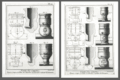 | Details | Benard, Robert | 1770 |
| Fonte des Canons |
|
Benard, Robert |
|
| 1770 |
| LOC:0 |
| $875.00 | Benard--Robert | Fonte-des-Canons | A fine gift for anyone with an interest in engineering, weaponry, or European history. A scarce pair (2) of archivally-matted antique copperplate engravings by Robert Benard depicting large mortars ca. 1738. In the early 18th century a mortar was essentially a squat, wide tube with very thick walls to withstand high pressure.
<br></br>
<img src="/ZoomifyImages/SC_309/SC_309_400x300.jpg" alt="de Passebon: Bomb Ketch. 1690." width="200" align="bottom" style="margin: 5px 10px 5px 0px"> </BR>
<a href="https://www.rarecharts.com/ShowDetail/Creator/Henri-Sbonski-de-Passebon/Title/Galiote-a-bombe/309" target="_blank">The 'Galiote a bombe' </a>(bomb vessel or bomb ketch) pictured inset is an antique engraving in our inventory created ca. 1690 by French galley Captain Henry Sbonski de Passebon (1637-1705). Either one or two mortars were usually placed aboard a bomb vessel which could be one of two types of vessels, either a specially built ketch (ketch: a two-masted, fore-and-aft-rigged sailboat with a mizzenmast smaller than the foremast) or, as is the case here, a converted three-masted vessel where the foremast had been removed, to provide a good deck space forward for the mortars.
<BR> </BR>
As a Captain in France's Corps des Galere, de Passebon was intimately familiar with this type ship and he is reported to have participated during the French bombardment of Genoa in 1684 , aboard the "la Perle" .
</BR>
The cannon are decorated with crown and globe containing three fleur-de-lis, figures representing the French royal coat of arms in the eighteenth century. From Diderot's "Encyclopédie ou Dictionnaire raisonné des sciences, des arts et des métiers, par une Société de Gens de lettres. Total dimensions with mat about 16.5" W x 19.5" H. Mat approx 5" per side. "Benard direxit". |
| 1217 | 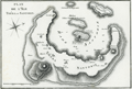 | Details | Benard, Robert | 1801 |
| Fine antique map of Santorini, Greece |
|
Benard, Robert |
|
| 1801 |
| LOC:0 |
| $170.00 | Benard--Robert | Fine-antique-map-of-Santorini--Greece | Very attractive map of the volcanic Greek island of <b>Santorini</b> ( Thera ) in the Aegean Sea. A very strong impression and meticulous attention to topographical detail make this an attractive candidate for framing.
<br></br>
Santorini lies within the Cyclades group of islands located in the southern part of the Aegean. The archipelago contains some 2,200 islands, islets and rocks but only 33 islands are inhabited.
<br?</br>
Includes the nearby islands of Thirasia, Palea Kameni and Nea Kameni. Numerous towns and villages within the island of Santorini are identified including:
<div class="indenttextblock">
<ul style="list-style-type: circle;">
<li>Apanomeria ( Oia )</li>
<li>Scauro</li>
<li>Phira ( Fira ) </li>
<li>Acrotiri or Akrotiri</li>
</ul>
</div>
From Guillaume Olivier: "Atlas Pour Servir au Voyage dans L 'Empire Othoman." Plate 7. |