| | Thumbnail | | Creator | Date | Title / Author / Date / Location | Price | | | Description |
| 5272 | 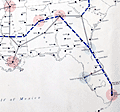 | Details | Bennett, Philip A. | 1949 |
| Earliest U.S. Government map television stations and networks |
|
Bennett, Philip A. |
|
| 1949 |
| LOC: |
| $1,250.00 | Bennett--Philip-A- | Earliest-U-S--Government-map-television-stations-and-networks | The earliest official large-format map of U.S. television stations and networks from the infancy of TV advertising. By U.S. Department of Commerce Industrial Economist Philip A. Bennet and printed by the U.S. Coast and Geodetic Survey in July, 1949. At the time of publication in 1949 the map clearly shows that numerous states were without a single operating TV station including: Nevada, Idaho, Montana, Colorado, Kansas, North Dakota, South Dakota, Nebraska, South Carolina, Vermont, New Hampshire, and Maine.
<br></br>
This map is scarce outside of institutional holdings. No copy of the map or record of the sale of this television map is found online. Price when issued 35 cents.
<br></br>
In January 1948, less than 200,000 TV sets existed in the U.S. This map documents the early distribution of broadcast TV stations, pre-dating the phenomenal growth of the industry. The map was and is important because the geographical distribution of TV stations impacted the size of the television market while TV networks served to lower the cost of content production.
<br></br>
Shows the 75 existing and 42 prospective analog broadcast television stations and <b>network routes</b> in the United States. Compiled and printed by the U.S. Coast and Geodetic Survey (Department of Commerce) to the specifications of Philip A. Bennet, General Products Division of the Office of Domestic Commerce.
<br></br>
See also Gould in NYT: https://timesmachine.nytimes.com/timesmachine/1949/04/24/93542916.html?pageNumber=299 |