| | Thumbnail | | Creator | Date | Title / Author / Date / Location | Price | | | Description |
| 788 | 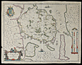 | Details | Blaeu, Johannes | 1640 |
| Antique map of the Danish Island of Fyn in the Baltic Sea |
|
Blaeu, Johannes |
|
| 1640 |
| LOC:0 |
| $0.00 | Blaeu--Johannes | Antique-map-of-the-Danish-Island-of-Fyn-in-the-Baltic-Sea | SOLD
<br></br>
Price includes shipping. Antique map of Fyn ( Funen ) in Denmark. Coverage includes the islands of Fyn ( Funen ), Denmark's third largest island; Langeland; Aeroe / Ærø ( Arr ) ; Als ( Alsen ); and the Western coast of Zeeland. Key cities noted include Odense ( Ottonia or Odensee ); Nyborg; Nackeby; Bogense ( Bowens ); and Hinsgagel, just below Middelfart. To the south lies the Baltic Sea ( Mare Balticum ). Dozens of smaller islands are each colored and are named, most encircling the island of Fyn.
<br></br>
This mid-seventeenth century copper-plate engraved map is characterized by beautiful flowing calligraphy, a vertical mileage scale, French text on the verso, and a title cartouche with two cow-herds surrounded by a herd of cattle. Three small ships under sail fill in the empty areas of the sea. Within the islands, numerous, villages, hills, lakes, rivers are identified by name. Created by prolific Dutch cartographer J. Blaeu from Amsterdam ca. 1640. |
| 1481 | 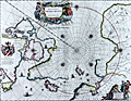 | Details | Blaeu, Johannes | 1645 |
| North Polar Region or Regiones Sub Polo Arctico |
|
Blaeu, Johannes |
|
| 1645 |
| LOC:52 |
| $1,900.00 | Blaeu--Johannes | North-Polar-Region-or-Regiones-Sub-Polo-Arctico | Beautiful engraved map of the North Polar region with fine color. With rhumb lines radiating from the North Pole, a large title cartouche, two figures and numerous wind heads, compass roses, ships and an additional vignette of explorers. Arctic animals shown include a polar bear and foxes. With Backer's coat-of-arms in "Nova Britannia." French text on verso regarding the "Pole Arctique".
<br></br>
Blaeu's map of the North Pole region is a close copy of Jansson's Nova et Accurata Poli Artici based on the arctic map of Barentsz, Baffin, and others. This is state two of the map with Willem Backer's coat-of-arms. |
| 357 |  | Details | Blaeu, Johannes | 1663 |
| Milazzo ou Melazzo ville en Sicile |
|
Blaeu, Johannes |
|
| 1663 |
| LOC:8 |
| $350.00 | Blaeu--Johannes | Milazzo-ou-Melazzo-ville-en-Sicile | Sizable map of the fortress at Milazzo, Italy published by Blaeu in 1663. Source was “Theatrum Civitatum et admirandorum Italiae” published from Amsterdam. This scarce antique map depicts the fortress walls in great detail but with no interior detail. The single decorative element is the depiction of a galley in the left bottom corner from which a sailor can be seen fishing. Plate 33. |