| | Thumbnail | | Creator | Date | Title / Author / Date / Location | Price | | | Description |
| 566 |  | Details | Blunt, E and G.W. | 1827 |
| Charleston Harbour |
|
Blunt, E and G.W. |
|
| 1827 |
| LOC:0 |
| $0.00 | Blunt--E-and-G-W- | Charleston-Harbour | SOLD
<br><br/>
Small, clean, nautical chart of Charleston Harbor, South Carolina from the 11th edition of the "American Coast Pilot" (1827). One of the earliest obtainable charts of Charleston Harbor by an U.S.-based cartographer. Noted features include Fort Johnson, a lighthouse and beacon, Cooper River, Hog Island, Sullivan's Island, Cummin's point, Colonel River's house, Lambell's house, and the Rattlesnake.
<br><br/>
The American Coast Pilot with other harbor charts, was published by Edmund and George W. Blunt from New York. The Blunts were the most prolific private publisher of navigational charts in the United States at that time.
<br><br/>
With numerous soundings and two profile views annotated with interesting comments regarding using the Charleston church steeples as an aid to navigation. The first profile states: "Charleston Churches appearing to Northward of Sullivan's I. there will be 5 1/2 fathoms on the Rattlesnake" and the lower profile: "Charleston Churches appearing to Southward of Sullivans I. you clear the Rattlesnake." |
| 104 |  | Details | Blunt, E and G.W. | 1841 |
| Plan of Portsmouth Harbour |
|
Blunt, E and G.W. |
|
| 1841 |
| LOC:0 |
| $0.00 | Blunt--E-and-G-W- | Plan-of-Portsmouth-Harbour | SOLD
<br></br>
Antique copperplate nautical chart of Portsmouth, New Hampshire harbor from this renowned American publisher of nautical charts and sailing directions. |
| 590 | 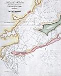 | Details | Blunt, E and G.W. | 1841 |
| Pensacola Harbor |
|
Blunt, E and G.W. |
|
| 1841 |
| LOC:11 |
| $0.00 | Blunt--E-and-G-W- | Pensacola-Harbor | Sold<br><br>Sold<br><br>
Small folding chart / map of Pensacola Harbor, Florida from 1841 published with other maps in Blunt's American Coast Pilot, 14th edition. The map include numerous soundings in feet. Named features on this copper-plate engraved antique chart include: one lighthouse ("revolving") , Santa Rosa Island, Deer Point, Tartar Point, Sandy Point and the very small town of Pensacola, Florida.
<br></br>
Printed by W. Hooker. Published by E. and G.W. Blunt, New York, 1841. Scale is displayed in statute miles. |
| 1038 |  | Details | Blunt, E and G.W. | 1847 |
| Newport Harbor, Rhode Island |
|
Blunt, E and G.W. |
|
| 1847 |
| LOC:0 |
| $0.00 | Blunt--E-and-G-W- | Newport-Harbor--Rhode-Island | SOLD<br></br>
Antique nautical chart of Newport Harbor, Rhode Island from the Blunts in their 16th edition of the American Coast Pilot, dated within to 1847. Noted features include Fort Adams, Castle Hill, Miantinomy Hill, Government Islands, and Lime Rocks.
<br></br>
The American Coast Pilot with other harbor charts and sailing directions, was published by Edmund and George W. Blunt from New York. The Blunts were the most prolific private publisher of navigational charts in the United States at that time. 179 Water Street New York. |
| 814 | 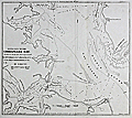 | Details | Blunt, E and G.W. | 1850 |
| Entrance to The Chesapeake Bay |
|
Blunt, E and G.W. |
|
| 1850 |
| LOC:0 |
| $0.00 | Blunt--E-and-G-W- | Entrance-to-The-Chesapeake-Bay | SOLD<br></br>
Pre Civil-war chart of the channels, banks, shoals, flats, and anchorages of the lower Chesapeake Bay between Mob Jack Bay and a line through Cape Henry and Cape Charles. The chart, created by Edmund Blunt, is from the 1850 edition of the "American Coast Pilot". 16th Edition.
<br></br>
Coverage includes: York River, James River, Hampton Roads, Lyn-Haven Roads, Fort Calhoun, and Smith's island. With numerous depth soundings and aids-to-navigation.
<br></br>
The American Coast Pilot with other harbor charts, was published by Edmund and George W. Blunt from New York. The Blunts were the most prolific private publisher of navigational charts in the United States at that time. The chart is based on earlier surveys by Adams and other members of the U.S. Navy.
<br><br/> |
| 1039 | 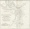 | Details | Blunt, E and G.W. | 1850 |
| Charleston Harbor, South Carolina |
|
Blunt, E and G.W. |
|
| 1850 |
| LOC:0 |
| $0.00 | Blunt--E-and-G-W- | Charleston-Harbor--South-Carolina | SOLD
<br></br>
Antique harbor chart (1850) for Charleston, South Carolina from the <b>Blunt's "American Coast Pilot" </b>. Noted features include Sullivan's Island, Rebellion Road, Light House Island, and Breach Inlet. Numerous beacons, depth soundings and contour lines are recorded.
<br></br>
<hr />
Special attention is due <b>Castle Pinckney</b> on Shutes Folly island shown between Charleston and Hog Island. "Fort Pinckney", the original log and earthen fort, named after the Revolutionary War hero Charles Pinckney, was built beginning in 1797 and was intended to protect the city from a possible naval attack. The log fort was destroyed by a severe hurricane in September 1804. A replacement brick-and-mortar structure called "Castle Pinckney" was erected in 1809 and was garrisoned throughout the War of 1812, but it saw no action.
<br></br>
By the late 1850s, Castle Pinckney was part of a array of defensive positions in the harbor, which included the strategically placed Forts Sumter and Moultrie, and other, smaller fortifications. In 1860, Castle Pinckney's artillery included fourteen 24-pounders, four 42-pounders, four 8-inch howitzers, and one 10-inch mortar.
<br></br>
On December 27, 1860, one week after South Carolina seceded from the Union, the fort was surrendered to South Carolina (S.C.) militia by its small U.S. Army garrison, which retired to Fort Sumter to join Major Robert Anderson. Castle Pinckney became the first Federal military installation seized forcefully by a Southern state government.
<hr />
<br />
The American Coast Pilot with other harbor charts and sailing directions, was published by Edmund and George W. Blunt from New York. The Blunts were the most prolific private publisher of navigational charts in the United States at that time. 179 Water Street New York. |
| 959 | 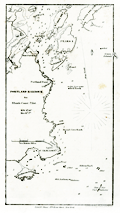 | Details | Blunt, E and G.W. | 1850 |
| Portland Harbor, Maine |
|
Blunt, E and G.W. |
|
| 1850 |
| LOC:3 |
| $75.00 | Blunt--E-and-G-W- | Portland-Harbor--Maine | Antique nautical chart of Portland Harbor, Maine from the Blunts in their 16th edition of the American Coast Pilot, published in 1850. Includes: the docks and wharves of Portland along the Fore River; Halfway River; Great Hog Island; Peaks Island; Bangs Island; Ram Island; Fort Preble; Portland Point Lighthouse; Richmond's Island; the Observatory; and Cape Elizabeth (with fixed revolving lights). Contains numerous depth soundings and fixes several offshore rocks and reefs including Bell Rock, Old Anthony, Alden's Rock, Taylor's Reef, Broad Cove Rock, and a set of rocks known as "Hue and Cry".
<br></br>
The American Coast Pilot with other harbor charts and sailing directions, was published by Edmund and George W. Blunt from New York. The Blunts were the most prolific private publisher of navigational charts in the United States at that time. 179 Water Street New York. |
| 965 | 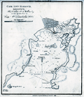 | Details | Blunt, E and G.W. | 1850 |
| Antique chart and plan of Cape Ann Harbor and Gloucester, Massachusetts |
|
Blunt, E and G.W. |
|
| 1850 |
| LOC:3 |
| $140.00 | Blunt--E-and-G-W- | Antique-chart-and-plan-of-Cape-Ann-Harbor-and-Gloucester--Massachusetts | Antebellum nautical chart of Gloucester ("Glocester"), MA. and Cape Ann Harbor from well known American publisher's of nautical charts and sailing directions, Edmund and George Blunt, and dated within to 1850. Noted features on this antique chart include <b>Ten Pound Island</b>, Ten Pound Island Ledge, Five Pound Island, Fort Point, Black Bess, Flat Point, and Norman's Woe Point with the nearby Norman's Woe Island. Includes numerous depth soundings, hazards, and aids to navigation as expected on a navigational chart. Shows a square fort at Fort Point near the Gloucester inner harbor but shows no structure in the location of Stage Point Fort.
<br></br>
The lighthouse on Ten Pound Island is shown near the mouth of the Gloucester inner harbor. The Ten Pound Island Light Station, originally a stone tower, was constructed on the island in 1821. That tower was replaced by the present cast-iron tower in 1881.
<br></br>
Topographic detail surrounding the harbor is shown through the use of light hachuring; numerous structures are shown scattered throughout that area.
<br></br>
The American Coast Pilot with other harbor charts, was published by Edmund and George W. Blunt from New York. The Blunts were the most prolific private publisher of navigational charts in the United States in the mid 19th century. |
| 957 |  | Details | Blunt, E and G.W. | 1850 |
| Doboy Sound and Sapello Island, Georgia |
|
Blunt, E and G.W. |
|
| 1850 |
| LOC:3 |
| $75.00 | Blunt--E-and-G-W- | Doboy-Sound-and-Sapello-Island--Georgia | Antique nautical chart of the entrance to Doboy Sound, Georgia from the Blunts, renowned American publisher's of nautical charts and sailing directions. Noted features include Sapello Island, Marsh Island, Cabarita Island, and Pelican Shoals with nearby north and south breakers at the far right. Numerous depth soundings and descriptions of the sea floor composition.
<br></br>
On the south end of Sapelo Island, structures are identified as those of Thomas Spalding, Esq. Spalding, of St. Simons Island, purchased the land from his father-in-law, Richard Leake, in 1802.
<br></br>
Blunt placed a "Ruin at Wolf Island" across from a "Ruin of Little Wolf Island". The history of these ruins are unknown but perhaps they are among the 1000 archaeological sites of native Americans that dot the area.
<br></br>
The American Coast Pilot with other harbor charts, was published by Edmund and George W. Blunt from New York. The Blunts were the most prolific private publisher of navigational charts in the United States in the mid 19th century. |
| 958 | 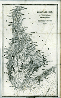 | Details | Blunt, E and G.W. | 1850 |
| Delaware Bay |
|
Blunt, E and G.W. |
|
| 1850 |
| LOC:0 |
| $0.00 | Blunt--E-and-G-W- | Delaware-Bay | SOLD<BR></BR>
Antique nautical chart of Delaware Bay from the Blunts in their 16th edition of the American Coast Pilot, published in 1850. This old chart is a reduced size version of a hydrographic chart originally published by the U.S. Coast Survey.
<br></br>
Extends from Reedy Point at the north end of Delaware Bay (near Salem, NJ) to Hen and Chickens shoal offshore of Cape Henlopen and Cape May, New Jersey.
<br></br>
The American Coast Pilot with other harbor charts, was published by Edmund and George W. Blunt from New York. The Blunts were the most prolific private publisher of navigational charts in the United States at that time. |
| 813 |  | Details | Blunt, E and G.W. | 1850 |
| Boston Harbour Chart |
|
Blunt, E and G.W. |
|
| 1850 |
| LOC:0 |
| $0.00 | Blunt--E-and-G-W- | Boston-Harbour-Chart | SOLD
<br><br/>
Small, clean, nautical chart of Boston Harbor, Massachusetts from the 1850 edition of the "American Coast Pilot" 16th Edition. Numerous soundings, marked aids-to-navigation, and anchorages would have made this a useful tool for navigators attempting to navigate in the area, one of the few mass-produced, affordable charts of the area that were available at that time.
<br><br/>
The American Coast Pilot with other harbor charts, was published by Edmund and George W. Blunt from New York. The Blunts were the most prolific private publisher of navigational charts in the United States at that time. The chart is based on earlier surveys by A.S. Wadsworth around 1818 and of Joseph Frederick Wallet Des Barres (1721-1824) during the American Revolutionary War. |
| 966 | 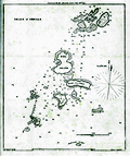 | Details | Blunt, E and G.W. | 1850 |
| Antique chart of the Isles of Shoals in Massachusetts and New Hampshire |
|
Blunt, E and G.W. |
|
| 1850 |
| LOC:0 |
| $0.00 | Blunt--E-and-G-W- | Antique-chart-of-the-Isles-of-Shoals-in-Massachusetts-and-New-Hampshire | SOLD<br></br>
Antique antebellum nautical chart of the islands comprising the <b>Isles of Shoals</b> offshore the town of Portsmouth, New Hampshire. Published by well known American publisher's of nautical charts and sailing directions, Edmund and George Blunt. Dated within the bottom attribution at 1850. Blunt's chart is probably the earliest hydrographic chart to focus solely on the Isles of Shoals.
<br></br>
There are nine islands that make up the Isles of Shoals, not all are named in Blunt's chart. In Maine the islands are: <b>Appledore ("Hog Island")</b>, Duck, Lunging ("Londoners"), Malaga (not named by Blunt), Smuttynose, and Cedar. In New Hampshire there are Seaveys (not named by Blunt), Star, and White.
On Star Island, <b>Gosport</b> (not named by Blunt) is shown as simply three structures and a church, but the chart does show the breakwater built in 1821 between Smuttynose and Cedar Islands.
<br></br>
From the 16th edition of the American Coast Pilot with other harbor charts, published by Edmund and George W. Blunt from New York. The Blunts were the most prolific private publishers of navigational charts in the United States in the mid 19th century. Page 41. |
| 960 | 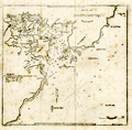 | Details | Blunt, E and G.W. | 1850 |
| Portsmouth Harbor, New Hampshire |
|
Blunt, E and G.W. |
|
| 1850 |
| LOC:3 |
| $75.00 | Blunt--E-and-G-W- | Portsmouth-Harbor--New-Hampshire | Antique nautical chart of Portsmouth Harbor, New Hampshire from the Blunts in their 16th edition of the American Coast Pilot, published in 1850.
<br></br>
The American Coast Pilot with other harbor charts and sailing directions, was published by Edmund and George W. Blunt from New York. The Blunts were the most prolific private publisher of navigational charts in the United States at that time. 179 Water Street New York. |
| 970 | 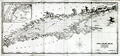 | Details | Blunt, E and G.W. | 1851 |
| Antique antbellum chart of Long Island Sound |
|
Blunt, E and G.W. |
|
| 1851 |
| LOC:0 |
| $0.00 | Blunt--E-and-G-W- | Antique-antbellum-chart-of-Long-Island-Sound | SOLD
<br></br>
Antique antebellum nautical chart of the coasts and islands comprising <b>Long Island Sound.</b> Coverage includes parts of the coasts of New York, Connecticut, and Rhode Island. Key features include Block Island, Fisher Island, <b>Mystic</b>, New London, New Haven, Darien, Stamford, Oyster Bay, Great Peconie Bay, Sag Harbor, Gardiners Bay, and Montauk Point. With numerous soundings, aids to navigation and, navigational hazards. Dated within at 1851.
<br></br>
With an inset map at upper right of New York City with <b>Manhattan</b>, the North River and East River.
<br></br>
From the 16th edition of the American Coast Pilot with other harbor charts, published by Edmund and George W. Blunt from New York. The Blunts were the most prolific private publishers of navigational charts in the United States in the mid 19th century. Page 41. |