| | Thumbnail | | Creator | Date | Title / Author / Date / Location | Price | | | Description |
| 5091 | 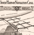 | Details | Board of Commissioners of the Port of New Orleans | 1923 |
| Early Map of New Orleans Inner Harbor Navigation Canal |
|
Board of Commissioners of the Port of New Orleans |
|
| 1923 |
| LOC:3 |
| $250.00 | Board-of-Commissioners-of-the-Port-of-New-Orleans | Early-Map-of-New-Orleans-Inner-Harbor-Navigation-Canal | Scarce early promotional map in an advertisement for the New Orleans Inner Harbor Navigation Canal (the Industrial Canal), a 5 1/2 mile waterway linking Lake Ponchartrain to the Mississippi River. Published from New Orleans, Louisiana by the Board of Commissioners of the Port of New Orleans in 1923, the year the canal opened.
<br></br>
At center right is shown a "possible location of deep-sea connection", a concept that was later, in 1965, to become the Mississippi River Gulf Outlet (MRGO) providing a shorter link for shipping traffic from New Orleans to the Gulf of Mexico.
<br></br>
Published in the May 12, 1923 edition of The Traffic World Magazine by the Traffic Service Corporation. Volume XXXI No. 19. P. 1090. |