| | Thumbnail | | Creator | Date | Title / Author / Date / Location | Price | | | Description |
| 218 | 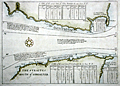 | Details | Bolland, Richard | 1730 |
| The Straites Mouth of Gibralter |
|
Bolland, Richard |
|
| 1730 |
| LOC:8 |
| $675.00 | Bolland--Richard | The-Straites-Mouth-of-Gibralter | Antique hydrographic chart of the Strait of Gibraltar including both Spanish and Moroccan coasts created by Captain Richard Bolland to illustrate his systematic hydrographic description of the currents and tidal flows in that area. Bolland's work, "A Draught of the Streights of Gibraltar with Some Observations upon the Currents thereunto Belonging", dated July 24, 1675 was based on Bolland's first-hand observations and measurements while living in Tangiers for nine years. The chart includes substantial tide tables and information on currents in the Strait.<BR> </BR>
This work of Bolland is clearly the source of Mortier's later similar engraving of the Strait published ca. 1705. Mortier pirated this work to publish in Amsterdam along with many other works in an age before international copyright law. <BR> </BR>
Published (and attributed to Bolland) by Awnsham and John Churchill ca. 1704 at the end of Volume 4 of their publication: "A Collection of Voyages and Travels". Page 777. English text. Verso blank. <BR> </BR>
Online copy of Bolland's text provides interesting background for the methodology that Bolland used to develop the chart (http://www.canadiana.org/view/33300/812 ). |