| | Thumbnail | | Creator | Date | Title / Author / Date / Location | Price | | | Description |
| 821 | 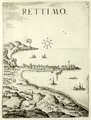 | Details | Boschini, Marco | 1651 |
| Rethymno in Crete, Greece |
|
Boschini, Marco |
|
| 1651 |
| LOC:0 |
| $0.00 | Boschini--Marco | Rethymno-in-Crete--Greece | SOLD<br></br>
Rare profile view of the Cretan village of Rettimo (Rethimno), Crete in Greece . The town is shown as it then existed, a narrow peninsula with the port and its jetties jutting out to the East. The great Fortress of Rethymno is clearly visible high and well protected at the northern end of the peninsula. Galleys and sea serpents fill empty space in the sea.
<br></br>
By Marco Boschini (1613-1678) from Venice in 1651. Published in Boschini's atlas of 59 engraved views and city plans and 2 maps of Crete at a time when the island of Crete, then a Venetian territory, was under siege from Ottoman forces.
<br></br>
Boschini derived his engravings from the manuscript works of others including Angelo degli Oddi, Francesco Basilicata, and especially Georgio Corner. Although he never visited Crete, Boschini's unique contribution is that his atlas was the first published atlas to focus solely on Crete and it provided information about that embattled island to a thirsty public. (Porfyriou, Helene. The Cartography of Crete in the First Half of the 17th Century: a Collective Work of a Generation of Engineers, Web; http://ine-notebooks.org/index.php/te/article/viewFile/109/165) |
| 822 | 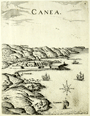 | Details | Boschini, Marco | 1651 |
| Chania in Crete, Greece |
|
Boschini, Marco |
|
| 1651 |
| LOC:0 |
| $0.00 | Boschini--Marco | Chania-in-Crete--Greece | SOLD<br></br>
Rare view of the walled town of Chania on the Greek island of Crete in context with the surrounding geographic features and villages. The small walled town on the North coast of Crete can be seen have the same harbor structure and covered workshops of the Grand Venetian Arsenal as still exist today. Noted nearby features include : Galata ( Galatas ), S. Fanavro,and S. Chiriaci. A simple wind rose is found in the sea along with images of a galley under oars and three square-rigged ships under sail.
<br></br>
By Marco Boschini (1613-1678) from Venice in 1651. Published in Boschini's atlas of 59 engraved views and city plans and 2 maps of Crete at a time when the island of Crete, then a Venetian territory, was under siege from Ottoman forces.
<br></br>
Boschini derived his engravings from the manuscript works of others including Angelo degli Oddi, Francesco Basilicata, and especially Georgio Corner. Although he never visited Crete, Boschini's unique contribution is that his atlas was the first published atlas to focus solely on Crete and it provided information about that embattled island to a thirsty public. (Porfyriou, Helene. The Cartography of Crete in the First Half of the 17th Century: a Collective Work of a Generation of Engineers, Web; http://ine-notebooks.org/index.php/te/article/viewFile/109/165) |
| 823 | 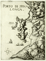 | Details | Boschini, Marco | 1651 |
| Spinalonga Peninsula and Elounda in Crete, Greece |
|
Boschini, Marco |
|
| 1651 |
| LOC:2 |
| $450.00 | Boschini--Marco | Spinalonga-Peninsula-and-Elounda-in-Crete--Greece | Very scarce and attractive copper-plate engraved view of the entire Spinalonga Peninsula and surrounding area on the island of Crete, Greece. Includes the island of Kalydon (shown with a fortress dominating the bay); the island of "Colochita" ( Kolokythas ); and structures in the vicinity of today's villages of Elounda and Plaka. The southern-most of these structures at the bottom of the Bay of Elounda are referred to as "Culata". The view shows a signal fire burning at the headland of Cape Agios Ioannis, overlooking the entire Mirambellos Gulf. Numerous galleys are shown at sea headed to shore, and interestingly none of the galleys are under sail.
<br></br>
By Marco Boschini (1613-1678) from Venice in 1651. Published in Boschini's atlas of 59 engraved views and city plans and 2 maps of Crete at a time when the island of Crete, then a Venetian territory, was under siege from Ottoman forces.
<br></br>
Boschini derived his engravings from the manuscript works of others including Angelo degli Oddi, Francesco Basilicata, and especially Georgio Corner. Although he never visited Crete, Marco Boschini's unique contribution is that his atlas was the first published atlas to focus solely on Crete and it provided information about that embattled island to a thirsty public. (Porfyriou, Helen. The Cartography of Crete in the First Half of the 17th Century: a Collective Work of a Generation of Engineers, Web: http://ine-notebooks.org/index.php/te/article/viewFile/109/165) |