| | Thumbnail | | Creator | Date | Title / Author / Date / Location | Price | | | Description |
| 728 | 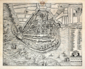 | Details | Braun and Hogenberg | 1571 |
| Plan of Enkhuizen, Netherlands |
|
Braun and Hogenberg |
|
| 1571 |
| LOC:89 |
| $440.00 | Braun-and-Hogenberg | Plan-of-Enkhuizen--Netherlands | Very special and much underappreciated plan of Enkhuizen, Netherlands published by Braun and Hogenberg but probably drawn by famous cartographer Lucas Janszoon Waghenaer, pre-dating his famous atlas the "Spiegel der Zeevaerdt". This is to our knowledge the first readily available work by Waghenaer who was born and raised in Enkhuizen, Netherlands |
| 123 |  | Details | Braun and Hogenberg | 1598 |
| Caletum |
|
Braun and Hogenberg |
|
| 1598 |
| LOC:89 |
| $850.00 | Braun-and-Hogenberg | Caletum | A decorative antique view / plan of Callais, France by Braun and Hogenberg. The engraving records a brief moment in history 1596 - 1598 during which Callais was taken from the French and occupied by Spain. This was a tumultuous time, less than a decade after the failed "invincible armada" in which Spain attempted to invade and occupy England. Shown in the foreground near the landward drawbridge are two Spanish soldiers- a pike man and an arquebusier. The depiction of Dover, England at the far top of the engraving is a reminder of Callais' strategic position on the English Channel. |