| | Thumbnail | | Creator | Date | Title / Author / Date / Location | Price | | | Description |
| 4934 | 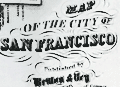 | Details | Britton and Rey | 1858 |
| Map of the City of San Francisco |
|
Britton and Rey |
|
| 1858 |
| LOC:0 |
| $2,200.00 | Britton-and-Rey | Map-of-the-City-of-San-Francisco | Fine lithographed map of San Francisco, California with red overprinted circles at 1/4 mile intervals bound into the annual report described below. Stated by another dealer as "rare" and "one of the earliest maps of San Francisco published in the city."
<br/><br/>
Only 2 sales of these rare antebellum Britton & Rey lithographed maps are recorded in AMPR, only one previous sale of the red-overprinted edition. 2nd. ed. Originally issued in 1846, but not dated within; comparison to the first edition shows no differences except for red over-printing. Neither sale included the bound report. Britton & Rey were located on Montgomery Street at the corner with Commercial Street between 1854 and 1858 (Peters, California on Stone, p. 162).
<br/><br/>
Frontispiece shows a plan, "Diagram of the Chamber of the Board of Supervisors, 1863. H.P. Coon, President
<br/><br/>
The gilt-edged report into which the map is bound: " San Francisco Municipal Reports for the Fiscal Year 1862-'63" published at the orders of the Board of Supervisors. San Francisco: Printed at Charles F. Robbins & Company. No 417 Clay Street, between Sansome and Battery. 1863. Contains reports from City Auditors, City Surveyor and other department heads and city officials. 6" W x 9" H. Binding tight. Original covers with binders identification inside the front cover at top left: Bartling & Kimball, Binders, 505 Clay Street, San Francisco.
<br/><br/>
Spine (poor with 1" missing) reads: Municipal Reports, San Francisco 1862-663. Cover (good) reads: "Presented by the City of San Francisco." |