| | Thumbnail | | Creator | Date | Title / Author / Date / Location | Price | | | Description |
| 597 |  | Details | Buache, Jean Nicolas | 1807 |
| Ile de New-York Partie de Long-Island ou de l'Ile Longue |
|
Buache, Jean Nicolas |
|
| 1807 |
| LOC:0 |
| $0.00 | Buache--Jean-Nicolas | Ile-de-New-York-Partie-de-Long-Island-ou-de-l-Ile-Longue | SOLD<br></br>
Detailed topographic map of New York, Long Island and surrounding areas with positions of American and British military forces during the Battle of Brooklyn during August 22-27, 1776. This antique copperplate engraved map is attributed to J.N. Buache and includes many nautical points of interest, as during that period access from the sea was often faster than by land.
<br></br>
Named features include Fort Independence, Fort Lee, Hudson River, York Bay, Oyster Bay, Hell Gate, Governor's Island, the East River, Staten Island, Bergen, Flushing, Brooklyn, East Chester and West Chester. Numerous roads and the position of several named ships are also noted including the Roebuck, the Rose, the Greyhound, and the Thunder.
<br></br>
From John Marshall's "Vie de George Washington". Plate VII. |
| 691 | 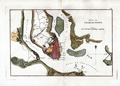 | Details | Buache, Jean Nicolas | 1807 |
| Charleston, South Carolina 1780 |
|
Buache, Jean Nicolas |
|
| 1807 |
| LOC:3 |
| $0.00 | Buache--Jean-Nicolas | Charleston--South-Carolina-1780 | SOLD
<br></br>
Antique engraved map of "Charlestown" ( Charleston, South Carolina ) in 1780 produced ca. 1807 in the French edition of John Marshall's "Life of Washington" (Vie De George Washington). The map depicts the general disposition of forces during the Siege of Charleston (March - May 1780) during the American Revolution . Shows a defensive wall partially surrounding the city and booms placed both at Fort Moultrie and near the Charleston harbor that were designed to deny passage to British naval vessels. Fort Sumter, which today guards the entrance to Charleston Bay and figures prominently in the U.S. Civil War as the site where the first shots were fired, is absent from the map because it was not constructed until 1829.
<br></br>
Noted points of interest identified on this antique map of Charleston include: James Island with Fort Johnson; Fort Moultrie at the West end of Sullivan's Island; Wappoo Creek; Pointe Cummin with a nearby hospital; Shutes Folly, Town Creek; Cooper River; and Hog Island. Fort Moultrie is of special interest as it was one in a series of defensive structures at that location on Sullivan's Island. The original fort built of palmetto logs at that spot inspired both the flag and nickname of South Carolina: "The Palmetto State".
<br></br>
Copper-plate engraved map, 200+ years old in good condition. Publisher: Dentu, Imprimeur-Libraire. Plate XIII. |