| | Thumbnail | | Creator | Date | Title / Author / Date / Location | Price | | | Description |
| 5317 | 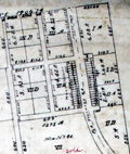 | Details | Campbell, H. J. | 1892 |
| Antique manuscript cadastral map Fernandez Grant Reddick Florida |
|
Campbell, H. J. |
|
| 1892 |
| LOC:1402 |
| $750.00 | Campbell--H--J- | Antique-manuscript-cadastral-map-Fernandez-Grant-Reddick-Florida | Manuscript ink cadastral plat map ca. 1892 of a portion of the Fernandez Grant near Reddick, Florida in Marion County. Made by engineer H. J. Campbell during a period of intensive agricultural growth, facilitated by numerous railroads in the area. The plat is dotted with numerous small unnamed lakes and sinkholes, a product of Florida's' limestone Karst topography. Hand drawn plat on tracing cloth- the map would have been used to generate blueprints on cyanotype paper. Scale 1 inch = 400 feet.
<br></br>
Top of map shows Reddick (established 1882) as a small settlement with a portion of the right of way for the Florida Southern Railroad. The Florida Southern Railway stopped in Reddick as early as 1881. The line went into receivership on March 19, 1890 and when it emerged in 1892 it was acquired by Henry B. Plant as part of his Plant System and reorganized as the Florida Southern Railroad, which stretched from Gainesville through Reddick to Ocala and then to Punta Gorda.
<br></br>
Starting in 1790, Spain offered land grants to encourage settlement to the sparsely populated and vulnerable Florida colony. When the United States assumed control of Florida, it agreed to honor any valid land grants. Portions of the map include lands near Reddick, Florida granted to Stephen Fernandez in 1817 or 1818.
Engineer H.J. Campbell drew a number of town plats in the Marion County area including Stanton and South Lake Weir. The earliest record of Campbell places him in Gainesville, Florida and in 1884 Campbell moved his office to Palatka, Florida. |