| | Thumbnail | | Creator | Date | Title / Author / Date / Location | Price | | | Description |
| 4966 | 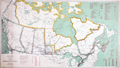 | Details | Canada Department of the Interior | 1911 |
| Antique Map of the Dominion of Canada |
|
Canada Department of the Interior |
|
| 1911 |
| LOC:1112 |
| $400.00 | Canada-Department-of-the-Interior | Antique-Map-of-the-Dominion-of-Canada | Antique map of the Dominion of Canada, with an emphasis on the Canadian Railroads, published by Canada's Department of the Interior . A reduced edition of the "Railway Map of the Dominion of Canada" aa much larger work of eight sheets totaling 100 inches in length.
<br></br>
Ottawa. R.E. Young, D.L.S. Chief Geographer.
<br></br>
Table at right shows a total of 1869 of track miles constructed in the Dominion of Canada during 1910 broken down into railway systems including:
<div class="indenttextblocksingle">
<ul style="list-style-type: circle;">
<li>Canadian Northern</li>
<li>Canadian Pacific</li>
<li>Grand Trunk Pacific</li>
<li>National Transcontinental</li>
<li>Algoma Central and Hudson Bay</li>
<li>Atlantic Quebec and Western</li>
<li>Sundry Railways</li>
</ul>
</div> |
| 4968 | 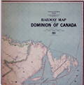 | Details | Canada Department of the Interior | 1911 |
| Railway Map of the Dominion of Canada |
|
Canada Department of the Interior |
|
| 1911 |
| LOC:0 |
| $700.00 | Canada-Department-of-the-Interior | Railway-Map-of-the-Dominion-of-Canada | Scarce antique railway map of the entire Dominion of Canada, from coast to coast, a work of eight sheets roughly totaling about 104 inches in length inside the neatline, over 9 feet wide including the margins. Call for complete photo set and condition report. No sale of this map is recorded in AMPR. No holdings of the 1911 edition of the Railway Map were found in WorldCat (1 holding of the 1910 edition).
<br></br>
Ottawa. R.E. Young, D.L.S. Chief Geographer. Scale 35 miles to one inch.
<br></br> |