| | Thumbnail | | Creator | Date | Title / Author / Date / Location | Price | | | Description |
| 696 | 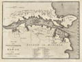 | Details | Cary, John | 1781 |
| Antique Plan of Mahon, Menorca, Spain |
|
Cary, John |
|
| 1781 |
| LOC:4 |
| $325.00 | Cary--John | Antique-Plan-of-Mahon--Menorca--Spain | Old antique engraved map and plan of the harbor and town of Mahon, the capital city of Menorca ( Minorca ) in the Balearic Islands, an archipelago and province of Spain in the Mediterranean Sea. Two areas of habitation are documented on the map, the largest consisting of the fortress and dwellings of St. Phillips town at the entrance to Mahon Harbor. In the vicinity of the fortress are a smaller structure- Charles Fort, St. Stephens Cove, Marlborough Redout, and just outside the walls, the Governor of the Castle's House.
<br></br>
Other noted points of interest around the harbor include Mast House, St. Anthony's Convent, Safron Island, Quarantine Island, Philipet Cove, Fort Philipet and a naval hospital on the aptly named "Bloody Island". A further 23 key points are noted and tied to a list of references at bottom with alphabetical indexes. These additional locations include: the Royal Counterguard, the Nunnery, and the Victualing Office for the Navy.
<br></br>
Admiral John Byng will forever be remembered for losing the island of Menorca to the French in 1756 near the beginning of what has come to be called "The Seven Years War". The island had been invaded and overrun by French forces with only Fort St. Philip remaining in British hands. Byng's failure to do his utmost to defeat the French fleet at the Battle of Minorca on May 20, 1756 and to recapture the fort and the island led to his court martial. Admiral Byng was found guilty and was later executed by firing squad on March 17, 1757 aboard the HMS Monarch while it lay at anchor in Portsmouth harbor.
<br></br>
Published from London by James Macgowan & William Davis. Dated within at Feb. 17, 1781. |
| 304 | 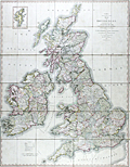 | Details | Cary, John | 1828 |
| Cary's Reduction of his Six Sheet Map of the British Isles |
|
Cary, John |
|
| 1828 |
| LOC:0 |
| $450.00 | Cary--John | Cary-s-Reduction-of-his-Six-Sheet-Map-of-the-British-Isles | Large, beautifully hand-colored antique folding map of the entire British Isles. John Cary's first map of the post roads, dated 1828. Good example of this map first published in 1796. Inset at upper right of the Shetland Isles. Maritime features include: the Atlantic Ocean, the German Ocean, the North Sea, the Irish Sea, St Georges Channel, and the English Channel.
<br></br>
Hand colored, dissected, and backed unto linen when issued. Folds into 42 parts. Marbled endpapers and complete with a green marbled slipcase to match that is labeled "Cary's two-sheet map of the United Kingdom." Published by G. and J. Cary, 86 St. James Street, London. |