| | Thumbnail | | Creator | Date | Title / Author / Date / Location | Price | | | Description |
| 8049 | 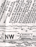 | Details | Chamberlain, Edward G. | 1904 |
| Rare Panoramic Map of the View from Great Blue Hill Milton Massachusetts |
|
Chamberlain, Edward G. |
|
| 1904 |
| LOC:41 |
| $0.00 | Chamberlain--Edward-G- | Rare-Panoramic-Map-of-the-View-from-Great-Blue-Hill-Milton-Massachusetts | SOLD<br><br>An extraordinary and rare panoramic view, recording the visible landscape from the summit of Great Blue Hill, one of the most prominent observation points south of Boston, Massachusetts. Drawn by the singular Edward G. Chamberlain, the heliotype-printed sheet presents a full 360 degree horizon broken into directional bands, identifying mountains, towns, rivers, railroads, and landmarks across eastern Massachusetts and beyond. This panorama and others Chamberlain produced have not been matched since. <br><br>
<div id="0" align="center">
<a title=""></a>
<img id="8049" src="/ZoomifyImages/SC_8049/SC_8049_Cover.jpg" alt="Cover photo of Guide to View from Great Blue Hill Milton by E. G. Chamberlain" width="140"/> <br><br> <font size="-2">Great Blue Hill Guide Cover</font>
</div>
<BR>
The panorama exemplifies Chamberlain’s distinctive method of what is now often described as concentric or radial cartography. From a single observation point, the surrounding landscape is organized outward by bearing, distance, and elevation, creating a systematic visual inventory of the terrain. Peaks as far away as New Hampshire, including Mount Monadnock, Barrett and KIdder, are placed in measured relationship to nearer hills, river valleys, and coastal features. Vertical scales are intentionally exaggerated to aid identification, a candid acknowledgment of the limits of human vision and atmospheric conditions. <BR><BR>Compiled between 1872 and 1886 (but 1904) during Chamberlain’s long association with the Appalachian Mountain Club, this map reflects the club’s early emphasis on careful observation, measurement, and documentation of the New England landscape. Chamberlain revised and refined such panoramas over decades, treating them as cumulative records rather than fixed compositions. Examples like this were distributed among fellow club members and used for route planning, lectures, and comparative study. Surviving sheets are scarce. |