| | Thumbnail | | Creator | Date | Title / Author / Date / Location | Price | | | Description |
| 2502 | 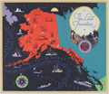 | Details | Chase, Francis J. | 1935 |
| The Last Frontier |
|
Chase, Francis J. |
|
| 1935 |
| LOC:10 |
| $350.00 | Chase--Francis-J- | The-Last-Frontier | Colorful and fun pictorial map of Alaska with pictures of flora, fauna, and native peoples. Prominently features the Japanese Current. Key named locations include Seattle, Bristol Bay, Aleutian Islands, Point Hope, and Point Barrow. Oceans colored black, with whales, local ships, a compass rose, iceberg, and rising sun. Rope-bordered cartouche decorated with nautical subjects, fishermen, float plane, and a totem pole.
<br></br>
Designed by J. Francis Chase. Copyright 1935 by Abbott Laboratories, North Chicago, Ilinois, producers of Abbott's Haliver Oil, a nutritional supplement derived from the liver of the halibut. |
| 7884 | 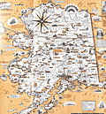 | Details | Chase, Francis J. | 1959 |
| Pictorial Map of Alaska, the 49th State |
|
Chase, Francis J. |
|
| 1959 |
| LOC: |
| $295.00 | Chase--Francis-J- | Pictorial-Map-of-Alaska--the-49th-State | Ernest Dudley Chase's "A Pictorial Map of Alaska, the 49th State" is a fascinating visual representation of Alaska's history and its journey to statehood. The map, created in 1959, celebrates Alaska's admission to the Union as the 49th state on January 3 of the same year. Chase's signature style, combining attractive illustrations with geographical information, provides a unique perspective on this momentous event in American history.
<br><br>
The Chase's map incorporates an alphanumeric grid system to help users easily locate specific points of interest. Surprisingly, the map retains its original advertising sticker, prominently displayed in the upper left corner, bearing a price of 50 cents. The presence of the sticker serves as a testament to its authenticity, further enhancing its overall value and desirability.
<br><br>
The map showcases various aspects of Alaskan life, including its natural resources, industries, and cultural heritage. Chase depicts the state's diverse landscapes, from the rugged coastlines to the majestic mountain ranges, highlighting the beauty and vastness of America's last frontier.
<br><br>
Chase's map also chronicles the historical events leading up to Alaska's statehood, such as the purchase of Alaska from Russia in 1867, known as "Seward's Folly," and the discovery of gold in the late 19th century, which led to the Klondike Gold Rush. The map portrays the development of Alaska's major cities, including Anchorage, Fairbanks, and Juneau, as well as the growth of its industries, such as fishing, mining, and logging.
<br><br> |