| | Thumbnail | | Creator | Date | Title / Author / Date / Location | Price | | | Description |
| 4710 |  | Details | Chatelain, Henry | 1695 |
| Carte Generalle du Gouvernement Militaire de France |
|
Chatelain, Henry |
|
| 1695 |
| LOC:0 |
| $250.00 | Chatelain--Henry | Carte-Generalle-du-Gouvernement-Militaire-de-France | Folio-size antique copperplate engraving on chain-laid paper by Chatelain. This scarce decorative historical artifact records the state of France's land and naval forces in 1695.
<BR> </BR>
Contains detailed textual information on the finances and disposition of France's military not found elsewhere and a wealth of images related to those sea forces. It includes views of major naval ports, weapons, emblems, and flags associated with both the regular navy and the galley corps.
<BR> </BR>
There was considerable inter-service rivalry between the sailing navy (vaisseaux) and the galley corps (galeres) of which there were then 40 vessels. The lower left quadrant contains a breakdown by type of the total 665 vaisseaux then in service. The lower right quadrant is dedicated solely to the galley corps, which was then near the peak of its power, listing the number of officers of each rank and the count of each galley type- for instance 1 Galere Reale (Royal Galley, the premier vessel). From the information provided by Chatelain we learn that 6 galleys would have been stationed outside the Mediterranean or Levant: 2 each in Bordeaux, St Malo, and Dunkirk.
<BR> </BR>
Less than 30 years after this engraving was published the Corps des Galeres was disbanded (1748), not able to compete against larger, better armed ships of the line. This sheet provides detailed historical background for collectors of <a rel="nofollow" href= "/MichelotBremondBackground.aspx">Michelot and Bremond</a> charts which were created during the period represented by this plate. Plate 28. |
| 128 | 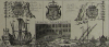 | Details | Chatelain, Henry | 1695 |
| Gouvernement Militaire de France |
|
Chatelain, Henry |
|
| 1695 |
| LOC:0 |
| $0.00 | Chatelain--Henry | Gouvernement-Militaire-de-France | SOLD
<BR> </BR>
Folio-size antique copperplate engraving on chain-laid paper by Chatelain that records the state of France's land and naval forces in 1695. Contains detailed textual information on the finances and disposition of France's military not found elsewhere and a wealth of images related to those sea forces. Includes views of major naval ports, weapons, emblems, and flags associated with both the regular navy and the galley corps.
<BR> </BR>
There was considerable inter-service rivalry between the sailing navy (vaisseaux) and the galley corps (galeres) of which there were then 40 vessels. The lower left quadrant contains a breakdown by type of the total 665 vaisseaux then in service. The lower right quadrant is dedicated solely to the galley corps, which was then near the peak of its power, listing the number of officers of each rank and the count of each galley type- for instance 1 Galere Reale (Royal Galley, the premier vessel). From the information provided by Chatelain we learn that 6 galleys would have been stationed outside the Mediterranean or Levant: 2 each in Bordeaux, St Malo, and Dunkirk.
<BR> </BR>
Less than 30 years after this engraving was published the Corps des Galeres was disbanded (1748), not able to compete against larger, better armed ships of the line. This sheet provides detailed historical background for collectors of <a rel="nofollow" href= "/MichelotBremondBackground.aspx">Michelot and Bremond</a> charts which were created during the period represented by this plate. Plate 28. |
| 938 | 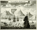 | Details | Chatelain, Henry | 1720 |
| View of Table Bay and Cape Town South Africa |
|
Chatelain, Henry |
|
| 1720 |
| LOC:6 |
| $295.00 | Chatelain--Henry | View-of-Table-Bay-and-Cape-Town-South-Africa | Attractive antique copper-plate engraving of Table Bay and early <b>Cape Town, South Africa</b>, about 40 miles north of the Cape of Good Hope. This very decorative view shows the nascent town of Cape Town with the Dutch Fort in the background and numerous ships at anchor in the foreground. In the far distance are Table Mountain and Devil's Peak. Table Bay was an important stop for resupplying ships making the passage to and from Europe and the East Indies.
<br></br>
With a textual description, in French, of the environs including that of nearby gardens and a small guest house or "Pavillon" of the <b>Dutch East India Company</b> near the garden. It was in that small guest house that a French embassy to Siam including six Jesuit priests set up an observatory during their stay in 1685. At bottom of the text is a engraved depiction of the guest house and gardens at night with a clock and telescope deployed to make astronomical observations; the Dutch fort visible in the background.
<br></br>
By Henri Chatelain, published in his <b>"Atlas Historique"</b> between 1705 and 1720.
<br></br>
Total size of page is 8" x 15"; the upper engraving of Table Bay and Mountain is 8" x 6". Book 6. No 17. Page 74. |