| | Thumbnail | | Creator | Date | Title / Author / Date / Location | Price | | | Description |
| 1081 | 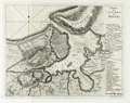 | Details | Coltellini, Marco | 1763 |
| Antique harbor chart and plan of Havana, Cuba |
|
Coltellini, Marco |
|
| 1763 |
| LOC:10 |
| $425.00 | Coltellini--Marco | Antique-harbor-chart-and-plan-of-Havana--Cuba | Antique chart from 1763 of the city and harbor of <b>Havana </b> on the island of Cuba. Two legends at far right in Italian are keyed to specific locations on the map including: the market; the Cathedral; churches; the powder magazine; defensive batteries and gun emplacements. Numerous soundings and shallow areas are identifed within the harbor. "Forte Moro" (<b>Morro Castle</b>) is clearly drawn opposite "Puntale" or San Salvador de la Punta Fortress, both guarding the entrance to the harbor.
<br></br>
Created by Marco Coltellini, drawn by Gieuseppe Pazzi, and published in volume 2 of the 1763 edition of the magazine "Il gazzettiere Americano" |
| 1088 | 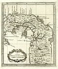 | Details | Coltellini, Marco | 1763 |
| Attractive antique map of the Isthmus of Panama |
|
Coltellini, Marco |
|
| 1763 |
| LOC:5 |
| $325.00 | Coltellini--Marco | Attractive-antique-map-of-the-Isthmus-of-Panama | Detailed and interesting antique (1763) engraved map of the Isthmus of Panama (Spanish: Istmo de Darien) showing interior detail and the Bay of Panama. Noted feautures include Portobelo ("Porto Bello"), Panama City, and Nuova Edinburg . New Edinburg was the site of the "Darien Scheme", a colony called "Caledonia" supported by the Kingdom of Scotland in the late 1690's. That unsuccessful colony was established by the Scottish Darien Company in an attempt to create a trading point between Europe and the Far East. The attempt was a disaster. When it failed the venture cost Scotland of an estimated quarter of its liquid assets and was an important factor in encouraging the country to the 1707 Act of Union which united the Kingdoms of Scotland and England.
<br></br>
The Gulf of Darién is the southernmost region of the Caribbean Sea, located north and east of the border between Panama and Colombia. Within the gulf is the Gulf of Urabá, a small lip of sea extending southward, between Caribana Point and Cape Tiburón, Colombia, on the southern shores of which is the port city of Turbo, Colombia.
<br></br>
Published from Livorno, Italy in 1763 in "Il Gazzettiere americano". |
| 1089 | 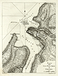 | Details | Coltellini, Marco | 1763 |
| Attractive antique plan of Chagres, Panama and Fort San Lorenzo |
|
Coltellini, Marco |
|
| 1763 |
| LOC:5 |
| $325.00 | Coltellini--Marco | Attractive-antique-plan-of-Chagres--Panama-and-Fort-San-Lorenzo | Finely engraved, antique (1763) port plan of Fort San Lorenzo and the town of Chagres, Panama on the north coast of Panama, now abandoned. Features include Chagres village, Castillo San Lorenzo, Forte della Punta, numerous depth soundings and a road labeled "Strado de Vento de Cruzes 56 miglia, e a Panama".
<br></br>
Spain's early trail to Panama City, the Las Cruces Trail, was reliant on the Chagres River for much of its route. Spain established Chagres at the mouth of the Chagres River, in the 16th century as a port for the purpose of loading its Peruvian plunder for trans-shipment to Nombre de Dios or Portobello where it would be consolidated and shipped onward to Spain. To protect the port, the Spanish established a fort, San Lorenzo, on a cliff overlooking the harbor.
<br></br>
Published from Livorno, Italy in 1763 in "Il Gazzettiere americano". |