| | Thumbnail | | Creator | Date | Title / Author / Date / Location | Price | | | Description |
| 7949 | 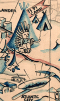 | Details | Crawford, Helen | 1938 |
| Manuscript Pictorial map of Wyoming |
|
Crawford, Helen |
|
| 1938 |
| LOC:41 |
| $0.00 | Crawford--Helen | Manuscript-Pictorial-map-of-Wyoming | SOLD<br><br>
“Wonderful Wyoming,” drawn by Helen Crawford, is a mid-century manuscript pictorial map that captures the frontier spirit of the state with humor and affection. Rendered in soft blue and brown tones, the map transforms Wyoming’s broad landscapes into a lively stage of cartoonish mountains, tipis, and cowboys. Around the border, the repeated phrase “Wonderful Wyoming” gives the composition a rhythmic frame, as if to remind the viewer that the state’s rugged charm deserves celebration. <br><br>
Across its hand-drawn expanse, Crawford places familiar landmarks—Yellowstone and Teton Parks in the northwest, the Big Horn Mountains, and the oil fields and cattle country near Casper and Cheyenne. The Oregon Trail winds through covered wagons, while Alcova Dam, fossil beds, and elk refuges mark modern and ancient layers of Wyoming’s identity. Each vignette balances history and industry, suggesting a state caught between its mythic past and its mid-twentieth-century progress.
<br><br>
Little is known of Helen Crawford herself, but her work belongs to a distinctly American moment when tourism, optimism, and regional pride converged on paper. Like other pictorial maps of the 1930s and 1940s, her “Wonderful Wyoming” invites viewers not just to locate a place but to feel it—to trace its highways and histories in inked gestures that are both informative and endearing.
<br><br>
This pictorial map of Wyoming is dated ca. 1938 based on the drawing on the Alcova Dam, comparing it to known photographs.<br><br> |