| | Thumbnail | | Creator | Date | Title / Author / Date / Location | Price | | | Description |
| 6800 | 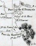 | Details | Dagelet, Joseph Lepaute | 1797 |
| Original antique French nautical chart of the west coast of North America |
|
Dagelet, Joseph Lepaute |
|
| 1797 |
| LOC: |
| $800.00 | Dagelet--Joseph-Lepaute | Original-antique-French-nautical-chart-of-the-west-coast-of-North-America | Original antique nautical chart of the west coast of North America from Mt. St. Elias (1) to Monterey Bay. Shows route of la Perouse. Includes the west coasts of California, Washington, and Oregon. From the atlas of the voyage by Lapérouse. Plate 16.
<br><br>
Jean-François de Galaup, Comte de Lapérouse was a French Naval officer and explorer whose journey started in 1785 under the commission of King Louis XVI. The expedition comprised two ships, the Astrolabe and the Boussole, and a crew of 225. The crew included scientists and artists who were tasked with documenting various aspects of the journey, including geography, wildlife, and indigenous cultures. This expedition aimed to complete the Pacific explorations undertaken by Captain Cook and others. The journey is noted for its tragic disappearance of Laperouse near the end.
<br><br>
The disappearance of Lapérouse's expedition sparked much interest and concern, leading to numerous rescue and search missions. The wreckage of the two ships was finally discovered in 1826 near Vanikoro, an island in the Solomon Islands, but the exact circumstances of the expedition's end remain a mystery.
<br><br>
(1) Mount St. Elias, located on the border between Alaska in the United States and Yukon in Canada, is one of the highest peaks in North America, at an elevation of 18,008 feet. It forms part of the St. Elias Mountain Range, which hosts some of the most extensive ice fields in the world. |