| | Thumbnail | | Creator | Date | Title / Author / Date / Location | Price | | | Description |
| 1210 | 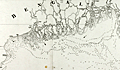 | Details | Dalrymple, Alexander | 1772 |
| Chart of the Northern Part of The Bay of Bengal |
|
Dalrymple, Alexander |
|
| 1772 |
| LOC:59 |
| $950.00 | Dalrymple--Alexander | Chart-of-the-Northern-Part-of-The-Bay-of-Bengal | Rare English sea chart, covering the mouth of the Ganges River and surrounding areas, by Alexander Dalrymple. Includes the population centers of Kolkata ("Calcutta") and Chittagong ("Islamabad") and the Chittagong Coast.
<br></br>
List of references at upper right of the chart contains a listing of islands, rivers, and creeks between Sagor and Chittagong.
<br></br>
Includes very extensive depth extensive soundings in fathoms. Arrows indicate the directions of strongest part of the flood-tide; Roman numbers show the high and low tides.
<br></br>
Published by Alexander Dalrymple on 15 September, 1772 "According to an Act of Parliament." In his doctoral thesis Cook wrote of Dalrymple that he was: <div class="indenttextblock"> "now generally regarded as the originator of official British hydrography… was cumulatively a private publisher of nautical charts and plans (from 1767), the 'examiner of ships' journals' and chart publisher for the East India Company (from 1779), and Hydrographer to the Admiralty (from 1795)". </div>
<br>
<div class="indenttextblock">Reference: Cook, Andrew S., <b>Alexander Dalrymple (1737 - 1808) Hydrographer to the East India Company and to the Admiralty; as publisher: A Catalogue of Books and Charts. </b> Vol. 3 .Doctoral Thesis, University of St. Andrews. 1992.</div> |
| 667 |  | Details | Dalrymple, Alexander | 1890 |
| Plan of the Harbor of Nangasaky ( Nagasaki ) |
|
Dalrymple, Alexander |
|
| 1890 |
| LOC:0 |
| $0.00 | Dalrymple--Alexander | Plan-of-the-Harbor-of-Nangasaky-(-Nagasaki-) | SOLD <br></br>
Very early and scarce chart of the harbor of Nagasaki, Japan by British hydrographer Alexander Dalrymple. Shows a palace complex, the Cavalles, Nombo Point, and a few buildings, along with several dozen soundings. In his doctoral thesis Cook wrote of Dalrymple that he was: <div class="indenttextblock"> "now generally regarded as the originator of official British hydrography… was cumulatively a private publisher of nautical charts and plans (from 1767), the 'examiner of ships' journals' and chart publisher for the East India Company (from 1779), and Hydrographer to the Admiralty (from 1795)". </div>
<br>
Dalrymple attributed the chart to a manuscript by Captain Alexander Hume. That manuscript chart was likely created by Hume while leading a commercial voyage of the East India Company ship "Fox" of 499 tons from March 1761 to July 1763.
<br></br>
First published by Alexander Dalrymple on August 31, 1788. This plate is a re-issue from Dalrymple's original copper plate and bears the stamp of the British Hydrographic Office: late 19th century or possibly early 20th century. Production of Dalrymple's charts continued after his death in 1808. Cook lists this chronology for publication of the chart: <div class="indenttextblock">"[The chart was] re-issued by Hurd after 1810; included in Admiralty Chart catalogues 1825-1855, and allocated chart number 1035; withdrawn before 1857.The printing plate is preserved in the Hydrographic Office."</div>
<br>
<div class="indenttextblock">Reference: Cook, Andrew S., <b>Alexander Dalrymple (1737 - 1808) Hydrographer to the East India Company and to the Admiralty; as publisher: A Catalogue of Books and Charts. </b> Vol. 3 .Doctoral Thesis, University of St. Andrews. 1992.</div> |
| 666 | 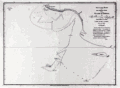 | Details | Dalrymple, Alexander | 1890 |
| Track of the ship Pearl in Persian Gulf 1797 |
|
Dalrymple, Alexander |
|
| 1890 |
| LOC:0 |
| $0.00 | Dalrymple--Alexander | Track-of-the-ship-Pearl-in-Persian-Gulf-1797 | SOLD <br></br>
Scarce copper plate engraved chart from 1797 of a portion of the coast in Hormozgan Province, Iran. Shows the Iranian coast near the island of Jezīrat Sheikh-Shuaib or Lavan Island ( Busheab Island ) and the present-day Nayband Marine-Coastal National Park. Other named features include Shitwa Island, Cape Nabon, Barn Hill, Cape Verdistan, Mongella Island, and Kenn Island. The chart contains soundings recorded by the Pearl during its exploration of the region during May 25 - 27, 1796.
<br></br>
Published by Alexander Dalrymple on May 7, 1797. This plate is a re-issue from the original copper plate bearing the stamp of the British Hydrographic Office; late 19th century or early 20th century.
<br></br>
In his doctoral thesis Cook wrote of Dalrymple that he was: <div class="indenttextblock"> "now generally regarded as the originator of official British hydrography… was cumulatively a private publisher of nautical charts and plans (from 1767), the 'examiner of ships' journals' and chart publisher for the East India Company (from 1779), and Hydrographer to the Admiralty (from 1795)". </div>
<br>
<div class="indenttextblock">Reference: Cook, Andrew S., <b>Alexander Dalrymple (1737 - 1808) Hydrographer to the East India Company and to the Admiralty; as publisher: A Catalogue of Books and Charts. </b> Vol. 3 .Doctoral Thesis, University of St. Andrews. 1992.</div> |