| | Thumbnail | | Creator | Date | Title / Author / Date / Location | Price | | | Description |
| 4786 | 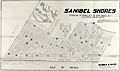 | Details | Davison, J. A. and Son | 1924 |
| 1924 cadastral plat of Sanibel Shores Subdivision, Sanibel Island, Florida |
|
Davison, J. A. and Son |
|
| 1924 |
| LOC:0 |
| $0.00 | Davison--J--A--and-Son | 1924-cadastral-plat-of-Sanibel-Shores-Subdivision--Sanibel-Island--Florida | SOLD
<br></br>
Folding cadastral map of a proposed subdivision "Sanibel Shores" on the southeast end of Sanibel Island, Florida platted with several hundred lots and over 3500 linear feet of Gulf frontage. With a smaller-scale inset map of the island placing the development in geographic context relative to the entire island. Surveyor's written location description states:
<div class="indenttextblock">
"Being a subdivision of Government lots 6-7-8 and that portion of lot 2 and the west 618.2 ft. of lot 1 that lies between the Gulf of Mexico and a bayou which is parallel with about 1800 feet from the meanders of the Gulf of Mexico, Section 30 T. 46 SR 23 E."
</div>
<BR/>
Today, Sanibel Shores would occupy a space roughly bounded to the south by the Gulf of Mexico; to the east by Nerita Street; to the north by Junonia Street, and to the west by Old Middle Gulf Drive. That area encompasses what has become the Sanibel Island Golf Club and a large portion of Beachview Country Club Estates. Major feeder road was Donax Street.
<br></br>
Frank P Bailey & C.R. Bailey Owners and Developers. Map based on survey by J.A. Davison & Son, Engineers, Fort Meyers, Florida Dec. 1924. Del. (drawn by) A.P. Vaughn.
<br></br>
Reybold & Gates Exclusive Sales Agents, Fort Meyers, Florida.
<br></br>
The old cadastral map is from the estate of the Mitchell C. Lilley family. The Lilley family owned an Gulf-front lot in this Sanibel Island subdivision, an un-numbered double-sized lot which is marked "Exception" on map. The Baileys are one of Sanibel's most notable families who arrived on the Island in the Mid-1890's. Frank and Ernest Bailey began farming on the Island and started the Sanibel Packing House in 1899 which became the Bailey General Store.
<br></br>
Scale 200 ft. to an inch. North oriented to upper right. |