| | Thumbnail | | Creator | Date | Title / Author / Date / Location | Price | | | Description |
| 539 | 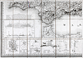 | Details | Donnet, Alejo | 1831 |
| Algarbe, Andalucia, Granada |
|
Donnet, Alejo |
|
| 1831 |
| LOC:0 |
| $575.00 | Donnet--Alejo | Algarbe--Andalucia--Granada | Map of the Algarve region in Portugal, southwest Spain, and the Strait of Gibraltar, with numerous city insets: Seville, Merida, Tarifa, Murviedro, Cadiz, Algeciras and Gibraltar. Large, attractive, well-kept, linen-backed folding map has been dissected into 18 sections of about 5.5 x 7.5 inches when issued. <BR> </BR>
The map's source is Donnet's six-sheet "Mapa Civil y Militar de España y Portugal, con la nueva división en distritos." Shows the Portuguese and Spanish coasts from Cape St. Vincent to well past Malaga along with the North African coast, Strait of Gibraltar, and Mediterranean Sea. Political regions and divisions are outlined in red. Published by Dauty and sold by Simonneau ca. 1831 from Paris. Hoja 4. <BR> </BR>
Contains two altitudinal cross sections. Detailed insets of key cities with prominent points identified and tied to a key for each city.<BR> </BR>
The map is unusual in that it presents 11 different measurement scales in alignment:<BR>
Leguas Geograficas de Espana<BR>
Leguas Legales de Espana<BR>
Leguas de Aragon<BR>
Leguas de Mallorquinas<BR>
Leguas Municipales Valencianas<BR>
Legoas communes de Portugal<BR>
Leguas Marimas o de 1 hora de Camino<BR>
Myriametres 10 por un grado decimal<BR>
Lieues de Poste de France 2000 toises<BR>
Lieues communes de France 2285 toises<BR>
British miles 1760 yards<BR> </BR>
Cover contains the seller's label in very fine condition that reads:<br>
"Magasin de Geographie de Charles Simonneau Graveur.
A Paris, Rue de la Paix, No. 6. Hotel Mirabeau vis-à-vis le Timbre. <br>
Cartes Geographiques et Topographiques Francaises et Etrangeres.<br>
Globes, Spheres, Atlas. Geographie, Ancienne et Moderne.<br>
(In manuscript): Espagne & Portugal Sud Ouest."<BR> </BR>
Not dated but Charles Simonneau was a French engraver, map publisher, and map seller in Paris, France from approximately 1803 to 1838. Grave par les Freres Malo, Rue du Ges No. 10. Pres la Sorbonne. |
| 540 | 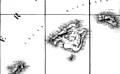 | Details | Donnet, Alejo | 1831 |
| Cuenca, Valencia, Murcia, Baleares |
|
Donnet, Alejo |
|
| 1831 |
| LOC:0 |
| $550.00 | Donnet--Alejo | Cuenca--Valencia--Murcia--Baleares | Antique map of the Balearic Islands: Ibiza, Formentera, Mallorca ( Majorca ), Menorca ( Minorca ); the Mediterranean Sea, and the East coast and interior of Spain. Published by Dauty and sold by Simonneau from Paris ca. 1831. Title printed on the map reads: "Cuenca, Valencia, Murcia, Baleares". The map's source is Donnet's six-sheet "Mapa Civil y Militar de España y Portugal, con la nueva división en distritos."
<BR> </BR>
Large, attractive, well-kept, linen-backed folding map dissected into 18 sections of about 5.5 x 7.5 inches as issued. Maps the Balearic Islands and the East coast of Spain from Mar Menor near Cartagena north to Barcelona. Political regions and divisions are outlined in red. <BR> </BR>
Cover contains the seller's label in very fine condition that reads:<br>
"Magasin de Geographie de Charles Simonneau Graveur.
A Paris, Rue de la Paix, No. 6. Hotel Mirabeau vis-à-vis le Timbre. <br>
Cartes Geographiques et Topographiques Francaises et Etrangeres.<br>
Globes, Spheres, Atlas. Geographie, Ancienne et Moderne.<br>
(In manuscript): "Espagne (illegible) centrales."<BR> </BR>
Not dated but Charles Simonneau was a French engraver, map publisher, and map seller in Paris, France from approximately 1803 to 1838. Engraving is attributed as: "Grave par les Freres Malo, Rue du Gres No. 10. Pres la Sorbonne." Contains index tab at top of the map: "No. 4". |
| 541 | 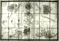 | Details | Donnet, Alejo | 1831 |
| Suplemento a los Planos de Ciudades |
|
Donnet, Alejo |
|
| 1831 |
| LOC:2001 |
| $500.00 | Donnet--Alejo | Suplemento-a-los-Planos-de-Ciudades | Scarce, detailed, antique folding map of plans for key cities in Spain and Portugal: Barcelona (still surrounded by a fortified wall), Ciudad Rodrigo, Tortosa, Oviedo, Denia, Cadiz, Granada, Lisbon (Lisboa), Madrid, Cartagena, and Valencia. The map was published as a supplement to Donnet's six-sheet "Mapa Civil y Militar de España y Portugal, con la nueva división en distritos."
<BR> </BR>
Large, attractive, well-kept, and linen-backed. Dissected into 18 sections of about 5.5 x 7.5 inches as issued. Published by Dauty and sold by Simonneau from Paris ca. 1831. The map is identified at top as the seventh and last part. <BR> </BR>
Cover contains the seller's label in very fine condition that reads:<br>
"Magasin de Geographie de Charles Simonneau Graveur.
A Paris, Rue de la Paix, No. 6. Hotel Mirabeau vis-à-vis le Timbre. <br>
Cartes Geographiques et Topographiques Francaises et Etrangeres.<br>
Globes, Spheres, Atlas. Geographie, Ancienne et Moderne.
With an index tab at top of the folded maps that reads: "Plans des Villes"<BR> </BR>
Not dated but Charles Simonneau was a French engraver, map publisher, and map seller in Paris, France from approximately 1803 to 1838. Attribution at bottom reads: " A Paris. Chez Dauty et Demaisons Palais Royal Galerie de Nemours, et Malo aine Graveur Rue St. Jacques No. 169." |