| | Thumbnail | | Creator | Date | Title / Author / Date / Location | Price | | | Description |
| 1047 | 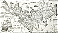 | Details | Dovarinoff, Jean | 1973 |
| Pictorial map of St. Barths with roads and beaches |
|
Dovarinoff, Jean |
|
| 1973 |
| LOC:0 |
| $0.00 | Dovarinoff--Jean | Pictorial-map-of-St--Barths-with-roads-and-beaches | SOLD<br></br>
Decorative, large, pictorial map of the Caribbean island of Saint Barthelemy (Saint Barths or St. Barts). Dated within to 1971/1973. St. Barts is a French territory located in the Caribbean Sea about 25 miles southeast of St. Martin. The capital of St. Barts is Gustavia. Details many of the fine beaches on the island including: Anse a Colombier, Anse de Grande Saline, Anse de Grand Cul de Sac, Anse de Lorient, and Anse du Gouvereur.
<br></br>
This scarce pictorial map of St. Barths, out of print for many decades, is decorated with sailing ships, fanciful sea creatures, pirates, and mermaids. A legend at far right explains the cartographic conventions used on this map. French text. Attribution reads: "Dressee par Jean Dovarinoff, le 30.3.1971 a l'anse des cayes, Saint Barthelemy, Guadeloupe." |