| | Thumbnail | | Creator | Date | Title / Author / Date / Location | Price | | | Description |
| 5319 | 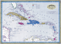 | Details | Dufour, Adolphe Hippolyte | 1850 |
| Antique Map of the Caribbean or Antilles |
|
Dufour, Adolphe Hippolyte |
|
| 1850 |
| LOC:11 |
| $255.00 | Dufour--Adolphe-Hippolyte | Antique-Map-of-the-Caribbean-or-Antilles | Fine engraved antique map of the Caribbean Islands from Florida to Venezuela. Map created by French cartographer A. H. Dufour ca. 1850.
<br></br>
Islands are colored according to the country who's possession each island was ceded to- England, Spain, France, Holland, Denmark, or Sweden. Legend or table at top center assigning colors to each occupying nation.
<br></br>
Engraved by Leclercq. Published by Mangeon. |