| | Thumbnail | | Creator | Date | Title / Author / Date / Location | Price | | | Description |
| 602 | 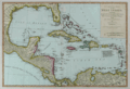 | Details | Dunn, Samuel | 1786 |
| Compleat Map of the West Indies |
|
Dunn, Samuel |
|
| 1786 |
| LOC:0 |
| $0.00 | Dunn--Samuel | Compleat-Map-of-the-West-Indies | SOLD<br></br>
Scarce antique nautical map focused on the Caribbean and the Gulf of Mexico. Interesting representation of Florida with the southern portion of that state shown as an archipelago of islands. Map coverage includes New Orleans, <b>Pensacola</b>, St. Augustine, <b>Amelia Island</b>, The Bahama Islands, Cuba, Jamaica, Puerto Rico, Virgin Islands, Leeward and Windward Islands, North Coasts of Colombia and Venezuela, Bay of Honduras, and Bay of Campeche. Earlier editions of this antique map are commonly found in the "The American Military Pocket Atlas" nicknamed the "Holster Atlas", issued to British Officers during the American Revolutionary War.
<br></br>
An interesting note on the map explains the derivation of terms "Windward" and "Leeward" to differentiate among two groups of islands in the southern Caribbean: <br><div class="indenttextblock ">
"The distinction between the Leeward and Windward Islands which is not commonly understood arose from the following circumstances. It was a custom going to the West Indies to make Island Desirada, the wind from the tropics blowing always from the East. All the islands to ye N. and W. of Desirada lay to the Leeward and all ye islands to the E. or S. lay to Windward of such ship's course T.P."</div>
<br></br>
The author, Samuel Dunn (d. 1794), taught navigation and other mathematical subjects and published several works on navigation, nautical science, and on astronomy. Published for Robert Sayer in June 1786. London. No. 53 Fleet Street. Plate 41. |