| | Thumbnail | | Creator | Date | Title / Author / Date / Location | Price | | | Description |
| 835 | 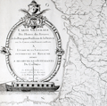 | Details | Dupain Triel, Jean-Louis | 1781 |
| Antique thematic map of French rivers and canals |
|
Dupain Triel, Jean-Louis |
|
| 1781 |
| LOC:0 |
| $3,000.00 | Dupain-Triel--Jean-Louis | Antique-thematic-map-of-French-rivers-and-canals | A large and rare antique thematic map of the rivers, streams, and canals of France with a very fine decorative cartouche. First and only edition. In two un-joined sheets. 36" W x 37" H when joined. Very decorative title cartouche with illustration of a late 18th century river barge with a large rudder; the size probably was necessitated by a small turning angle limited to the width of the barge cabin just aft of amidships. Possibly influenced by Sanson's 1641 "Carte des rivières de la France, curieusement recherchée" but Dupain-Triel's waterways map is much larger and contains greater detail.
<br></br>
Une grande et rare carte thématique antique des rivières, ruisseaux et canaux de France avec un très beau cartouche décoratif. Première et unique édition. Dans deux feuilles non jointes. 36 "L x 37" H une fois joint. Cartouche titre très décorative avec illustration d'une barge fluviale. Peut-être influencé par 1641 "Carte des rivières de la France de Sanson, curieusement recherchée" mais la carte des cours d'eau Dupain-Triel est beaucoup plus grande et contient plus de détails.
<br></br>
Both sheets of a 2 sheet map (not joined) of France by J.L. Dupain-Triel Sr. Rare, only one holding listed in OCLC/World Cat. Only two sales recorded in the AMPR.
<br></br>
In 1782 Dupain-Triel paid for the typesetting and engraving of a manuscript by Marcellin du Carla that proposed the use of contour lines as a means of adding elevation information to terrestrial maps and Dupain-Triel Sr. is distinguished as the maker of the first contour map of France in 1791, based on du Carla's method. This thematic map is noteworthy in that it does not contain any contour information although it is clear that when the map was published Dupain Triel Sr. had strong interest in the topic. (Konvitz, Joseph. "Cartography in France, 1660-1848: Science, Engineering, and Statecraft". University of Chicago Press. 1987. pp. 76-80.) |