| | Thumbnail | | Creator | Date | Title / Author / Date / Location | Price | | | Description |
| 733 | 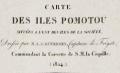 | Details | Duperrey, Louis-Isidore | 1824 |
| Chart of French Polynesia with Tahiti and Bora Bora |
|
Duperrey, Louis-Isidore |
|
| 1824 |
| LOC:59 |
| $575.00 | Duperrey--Louis-Isidore | Chart-of-French-Polynesia-with-Tahiti-and-Bora-Bora | Antique French hydrographic chart with the islands of Pomotou (Tuamotu Islands or French Polynesia). Other names include Archipel Dangereux, Archipel des Pomotou, Archipel des Tuamotu, Tuamotu Archipelago, Tuamotu Islands, and Îles Tuamotu. Includes the Society Islands ( Archipel de la Société ) of Tahiti ( Taiti ), Emeo, Huaheine, Bora Bora and many others and the Toubouai Islands.
<br></br>
Produced by French explorer Louis-Isidore Duperrey (1786-1865). Duperrey served as marine hydrologist to de Freycinet aboard the Uranie and commanded the corvette la Coquille on its westward world circumnavigation during the period 1822–1825 with Jules Dumont d'Urville as second in command. WorldCat only records one copy of this chart- at the Paris Museum National d'Histoire Naturelle.
<br></br>
Contains the tracks of many early voyages through the Pacific islands with dates of discovery for many islands. Discoverers include: Vancouver (1791), Carteret (1767), Bligh and Portlock (1792), Cook (1769), de Bougainville (1768), Lemaire and Schouten (1616) . Number 684. |
| 6737 | 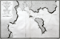 | Details | Duperrey, Louis-Isidore | 1824 |
| Chart of the Harbor of Doreri West Papua New Guinea |
|
Duperrey, Louis-Isidore |
|
| 1824 |
| LOC:59 |
| $500.00 | Duperrey--Louis-Isidore | Chart-of-the-Harbor-of-Doreri-West-Papua-New-Guinea | Copperplate engraved French nautical chart of the bay and harbor of Doreri in the Province of West Papua on the island of New Guinea, Indonesia. Duperrey explored the region in 1793 while searching for the missing expedition of Jean-François de La Pérouse. Shows the route of the Corvette "la Coquille" during July, 1824.
<br><br>
From 'Voyage autour du monde' ('Voyage round the world') by Louis Isidore Duperrey (1826). Plate 34. Engraved by Tardieu.
<br><br>
The bay is on the east coast of West Papua near the city of Manokwari, which is the capital of the province. One notable fact about the Bay of Doreri is that today it is home to Doreri Nature Reserve, which is a protected area encompassing coastal and marine ecosystems.
<br><br>
The chart includes these other nearby locations:
<div class="indenttextblocksingle">
<ul style="list-style-type: circle;">
<li>Point Ambla</li>
<li>Isle Manas-Ouari (Mansinam)</li>
<li>Isle Masmapi</li>
<li>Baie Masinami</li>
<li>Baie Ouahouzi</li>
<li>Cap Ouacalo</li>
</ul>
</div> |
| 883 | 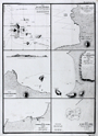 | Details | Duperrey, Louis-Isidore | 1827 |
| Old chart of the Galapagos Islands and anchorages |
|
Duperrey, Louis-Isidore |
|
| 1827 |
| LOC:0 |
| $550.00 | Duperrey--Louis-Isidore | Old-chart-of-the-Galapagos-Islands-and-anchorages | Antique French copper-plate engraved charts of the <b>Galapagos Islands</b> (Ecuador) and three ports in Colombia. Six charts and plans on a single sheet of heavy wove paper by Duperrey from the "Voyage autour du monde, exécuté par ordre du Roi, sur la corvette de Sa Majesté, La Coquille, pendant les années 1822, 1823, 1824 et 1825". Published by the Depot de la Marine - Hyd. Fr. N°. 725 N°. 42.
<br></br>
The charts include the following:
<div class="indenttextblock">
<ul>
<li>Carte des Iles Gallapagos d'aprés les observationes faites par Vancouver en 1791, par Davidson et le Capt. B. Hall en 1822. </li>
<li>Plan de la Baie Albany (Iles Gallapagos)</li>
<li>Plan de Mouillage de L'Ile Hood (Iles Gallapagos)</li>
<li>Plan de la Baye Salango (Colombie)</li>
<li>Plan du Mouillage de Tacames (Colombie)</li>
<li>Plan du Banc de la Perle (Ile de la Perle)</li>
</ul>
</div>
The <b>Banc de la Perle</b> is significant in that it was there that two British whalers grounded and were lost on April 24th, 1822. The combined crews salvaged parts and built a new vessel, the Deliverance, which some of the crew then sailed to Hawaii. The wreck site lay hidden until it was rediscovered by NOAA divers in 2004. <div class="indenttextblock"> (Pearl Site Survey 2006. National Oceanic and Atmospheric Administration.
<a href="http://sanctuaries.noaa.gov/maritime/expeditions/pearl.html" target="_blank">Internet</a>)
</div> |