| | Thumbnail | | Creator | Date | Title / Author / Date / Location | Price | | | Description |
| 4747 | 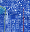 | Details | Edward E. Manning Company | 1925 |
| Cyanotype map of north Chicago and Evanston, IL |
|
Edward E. Manning Company |
|
| 1925 |
| LOC:62 |
| $320.00 | Edward-E--Manning-Company | Cyanotype-map-of-north-Chicago-and-Evanston--IL | Authentic hand-colored cyanotype (blueprint) Chicago-area map from ca. 1925. A fine, unique early 20th-century artifact that should appeal to collectors or others with interests in Evanston or Chicago, Illinois and its expansion into the suburbs. Cyanotype maps are generally scarce.
<br></br>
Coverage begins at W. Lawrence Avenue and extends north to Lake Avenue in Evanston, Illinois. Our map is bounded to the east by Lake Michigan and to the west a few blocks past Harlem Avenue. Shows the location of Northwestern University along Lake Michigan. Includes by name Morton Center, Edison Park, Rogers Park, and the town of "Niles Center", now Skokie, Il.
<br></br>
In the 19th century blueprints (cyanotype prints) were generally scarce as blueprinting had only been invented in the 1870's. By 1899 the cyanotype process was beginning to become widely adopted as a quick method of reproducing maps, plans, and architectural diagrams. Blueprinting was a well-accepted business tool in 1925.
<br></br>
Produced by the Edward E. Manning Company, 55 W. Wacker, Drive, Chicago. |