| | Thumbnail | | Creator | Date | Title / Author / Date / Location | Price | | | Description |
| 5154 | 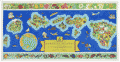 | Details | Edwards, Parker | 1937 |
| Dole Pictorial Map of the Hawaiian Islands 1937 |
|
Edwards, Parker |
|
| 1937 |
| LOC:63 |
| $1,100.00 | Edwards--Parker | Dole-Pictorial-Map-of-the-Hawaiian-Islands-1937 | Iconic pictorial map of the Hawaiian Islands drawn by Parker Edwards and published by the Hawaiian Pineapple Co., Ltd. In 1937. Includes the original, franked (4 cent) cardboard mailing tube. This extremely decorative 3-foot wide map is very desirable and somewhat scarce in this excellent A+ condition.
<br></br>
Top of the sheet contains a decorative border featuring a colorful assortment of local plant life. Lower border displays many of the bright, exotic fish that inhabit the waters around the islands of Hawaii.
<br></br>
Title:
<div class="indenttextblocksingle">
<ul style="list-style-type: circle;">
The Dole Map of the Hawaiian Islands U.S.A. being a Descriptive Portrayal of the History, Transportation, Industries and Geography of the Territory of Hawaii, U.S.A.
</ul>
</div> |