| | Thumbnail | | Creator | Date | Title / Author / Date / Location | Price | | | Description |
| 1476 | 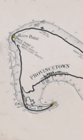 | Details | Eldridge, George W. | 1901 |
| Massachusetts Bay and Coast from Chatham to Gloucester 2 |
|
Eldridge, George W. |
|
| 1901 |
| LOC:0 |
| $300.00 | Eldridge--George-W- | Massachusetts-Bay-and-Coast-from-Chatham-to-Gloucester-2 | Chart D Massachusetts Bay and the Coast from Chatham to Gloucester, published by George W. Eldridge in 1901, is a navigational chart that accurately depicts the coastline, harbors, and navigational hazards along Massachusetts Bay, from Chatham in the south to Gloucester in the north.
<br><br>
The chart is highly detailed and includes information on soundings (water depth measurements), tides, currents, and other navigational data. It shows the location of lighthouses, buoys, beacons, and other aids to navigation, as well as the location of rocks, shoals, and other navigational hazards.
<br><br>
In addition to navigational aids, the chart also shows the names and locations of towns, cities, and other landmarks along the coast, providing a useful reference for sailors navigating the area. Coverage includes the coastal margins near the towns of Provincetown, Truro, Wellfleet, Brewster, Yarmouth, Plymouth, Scituate, Cohasset, Marblehead, Salem, Gloucester, and the town and harbor of Boston, Massachusetts. The chart was designed to be used by sailors and navigators, and its accuracy and level of detail made it an essential tool for safe navigation along the Massachusetts Bay.
<br><br>
Date printed in blue stamp "1901". Note: Price is discounted for condition. |
| 5224 | 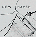 | Details | Eldridge, George W. | 1901 |
| Eldridges Antique Harbor Chart of New Haven, Connecticut |
|
Eldridge, George W. |
|
| 1901 |
| LOC:10 |
| $250.00 | Eldridge--George-W- | Eldridges-Antique-Harbor-Chart-of-New-Haven--Connecticut | Early 1901 harbor chart of the port of New Haven, Connecticut by George W. Eldridge. Key features noted include the Southwest Ledge Light, several breakwaters, Five Mile Point, Fort Hale, Sandy Point, Morris Cove, West Haven, and Fair Haven. Numerous aids to navigation, anchorages, and depth soundings.
<br></br>
Much useful information including soundings, anchorages, ranges, buoys, and bottom composition are presented by Eldridge in a clear graphic style that would have been helpful to mariners. The chart is printed with bold black coastal outlines that would have been much easier to read under poor lighting conditions. Lighthouses, buoys, and other aids to navigation are highlighted in red. Bottom composition is presented according to an attached table of abbreviations.
<br></br>
Attribution reads: 'AUTHORIZED and PUBLISHED By Geo. W. Eldridge, Vineyard Haven, Mass. and 152 State Street, Boston. Copyright by Geo. W. Eldridge 1901.' Number 17 in Eldridge's book of harbor charts. |
| 2553 | 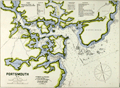 | Details | Eldridge, George W. | 1908 |
| Antique Chart of Portsmouth, New Hampshire |
|
Eldridge, George W. |
|
| 1908 |
| LOC:10 |
| $145.00 | Eldridge--George-W- | Antique-Chart-of-Portsmouth--New-Hampshire | Elegant, simple and useful early 20th-century antique nautical chart of Portsmouth, New Hampshire harbor and entrance. Nearby points of interest include Kittery, Seaveys Island, Gerrishes Island, Cutts Island, Newcastle Island, Little Harbor, Sagamore Creek and much more. By George W. Eldridge.
<br></br>
Much useful information including soundings, anchorages, ranges, buoys, and bottom composition are presented by Eldridge in a clear graphic style that would have been appreciated by and helpful to mariners. For instance, these charts are printed with bold black coastal outlines that would have been much easier to read under poor lighting conditions.
<br></br>
Attribution reads: 'AUTHORIZED and PUBLISHED By Geo. W. Eldridge, Vineyard Haven, Mass and 132 State St. Boston.' Number 56 from Eldridges book of harbor charts. Price 30 cents. |
| 777 | 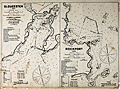 | Details | Eldridge, George W. | 1908 |
| Antique Chart of Gloucester Harbor and of Sandy Bay, Massachusetts |
|
Eldridge, George W. |
|
| 1908 |
| LOC:0 |
| $125.00 | Eldridge--George-W- | Antique-Chart-of-Gloucester-Harbor-and-of-Sandy-Bay--Massachusetts | Separately issued nautical charts of Gloucester Harbor and of Sandy Bay on the Cape Ann peninsula in Massachusetts. Includes the Massachusetts towns of Rockport and Gloucester. Other key features include Fresh Water Cove, Ten Pound Island, Southeast Harbor, Eastern Point, Thatcher's Island, Milk Island, Loblolly Cove, Whale Cove, Straitsmouth Island, The Rockport Granite Company, and Andrews Point. Much useful information including soundings, ranges, buoys, and bottom composition are presented in a clear graphic style that would have been appreciated by and helpful to mariners. For instance, these charts are printed with bold black coastal outlines that would have been easier to read under poor lighting conditions.
<br></br>
Attribution reads: 'AUTHORIZED and PUBLISHED By Geo. W. Eldridge, Vineyard Haven, Mass and 132 State St. Boston.' Price when issued was 30 cents. |
| 1299 | 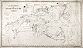 | Details | Eldridge, George W. | 1909 |
| Fine antique navigation chart for Martha's Vineyard and Nantucket MA |
|
Eldridge, George W. |
|
| 1909 |
| LOC:0 |
| $0.00 | Eldridge--George-W- | Fine-antique-navigation-chart-for-Martha-s-Vineyard-and-Nantucket-MA | <br><br>This item is <b>SOLD</b> but we have found another example of this item that is <a href="https://www.rarecharts.com/ShowDetail/Creator/Eldridge--George-W-/Title/G--W--Eldridge-navigation-chart-for-Martha-s-Vineyard-and-Nantucket-MA/6562" target="_blank">now in our inventory.</a>
<br></br>
George W. Eldridge's very desirable "Chart C" including both Martha's Vineyard and Nantucket in Massachusetts.
<br></br>
This large linen-backed chart includes the following ports and towns: Edgartown, Siasconset, Woods Hole, Nantucket town and more. The chart shows numerous coastal islands including Chappaquiddick Island, Cuttyhunk Island, Nashawena Island, Pasque Island, Naushon Island, No Man's Land, Tuckernut Island, Muskeget Island, and Monomoy Island. |
| 6562 | 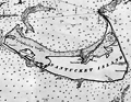 | Details | Eldridge, George W. | 1913 |
| G. W. Eldridge navigation chart for Martha's Vineyard and Nantucket MA |
|
Eldridge, George W. |
|
| 1913 |
| LOC:1406 |
| $0.00 | Eldridge--George-W- | G--W--Eldridge-navigation-chart-for-Martha-s-Vineyard-and-Nantucket-MA | SOLD<br><br>
A fine intact antique example of Eldridge's very desirable "Chart C" including the islands of Martha's Vineyard and Nantucket in Massachusetts. Once relatively plentiful, this splendid lithographed nautical chart by George Washington Eldridge is becoming increasing hard to find for sale.
<br><br>
Copyright by George W. Eldridge, 1912.
<br><br>
A very "user friendly" nautical chart that would have been appreciated by mariners in the early 20th century who lacked today's electronic navigational aids. This large linen-backed chart includes the following ports and towns: Edgartown, Siasconset, Nantucket town, Vineyard Haven, Oak Bluffs, Falmouth, Cotuit, Osterville, Hyannis, West Dennis, Harwich Port, and Chatham.
<br></br>
Shown numerous islands along the coast including Chappaquiddick Island, Cuttyhunk Island, Nashawena Island, Pasque Island, Naushon Island, No Man's Land, Tuckernut Island, Muskeget Island, and Monomoy Beach, now Monomoy Island.
<br></br>
Dotted with interesting comments and observations including:
<div class="indenttextblocksingle">
<ul style="list-style-type: circle;">
<li>"In passing Chatham in thick weather or night time bound to the Northward or Southward make use of the lead and do not go into less than 7 or 8 fathoms of water to avoid the bars that are rapidly extending from the shore and are dangerous."</li>
<li>"Vessels passing Nobska in either direction displaying signals will be reported by telegraph to the Boston Chamber of Commerce."</li>
<li>About the Nantucket Head of Harbor entrance: "Strangers should enter this place with caution as it changes with every storm from seaward."</li>
</ul>
</div>
Charles C. Hutchinson 152 State Street Boston General Agent. |
| 3588 | 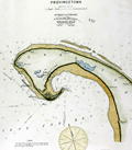 | Details | Eldridge, George W. | 1914 |
| Iconic Antique Chart of Provincetown, Mass. |
|
Eldridge, George W. |
|
| 1914 |
| LOC:10 |
| $450.00 | Eldridge--George-W- | Iconic-Antique-Chart-of-Provincetown--Mass- | Elegant, simple and useful early 20th-century antique nautical chart of Provincetown, Massachusetts on the island of Cape Cod, Mass. Very attractive hand coloring. Features include Race Point, Wood End Bar, North Truro, Clapp's Pond, Herring Cove, Shank Painter Pond; and the Highland, Crow Hill, and Peaked Hill Life Saving Stations.
<br></br>
Much useful information including soundings, anchorages, ranges, buoys, and bottom composition are presented by Eldridge in a clear graphic style that would have been appreciated by and helpful to mariners. For instance, this chart of Provincetown, MA. is printed with bold black coastal outlines that would have been much easier to read under poor lighting conditions. Lighthouses, buoys, and other aids to navigation are highlighted in red. Bottom composition is presented according to an attached table of abbreviations.
<br></br>
Published by Wilfrid O. White of Boston, Massachusetts. White was G. W. Eldridge's son-in-law who continued to sell Eldridge's charts after his death until 1932.
<br></br>
Attribution reads: 'AUTHORIZED and PUBLISHED By Geo. W. Eldridge, Kelvin & Wilfrid O. White Co. 112 State Street, Boston. 38 Water Street, New York ' Number 49 in Eldridge's book of harbor charts. |
| 2557 | 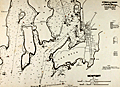 | Details | Eldridge, George W. | 1914 |
| Bold Antique Chart of Newport Rhode Island |
|
Eldridge, George W. |
|
| 1914 |
| LOC:0 |
| $0.00 | Eldridge--George-W- | Bold-Antique-Chart-of-Newport-Rhode-Island | SOLD<br></br>
Elegant, simple and useful early 20th-century antique nautical chart of Newport, Rhode Island harbor ca. 1914. Nearby points of interest include the Brenton Reef light-ship, Pirate's Cave, Castle Hill, Fort Dumpling, Coaster's Harbor Island, Dutch Island, Beaver Head, Jamestown and Sanderstown . Cartography by George W. Eldridge. Watermarked paper "Resolute Ledger".
<br></br>
Much useful information including soundings, anchorages, ranges, buoys, and bottom composition are presented by Eldridge in a clear graphic style that would have been appreciated by and helpful to mariners. For instance, this chart of Newport, R.I. is printed with bold black coastal outlines that would have been much easier to read under poor lighting conditions. Lighthouses, buoys, and other aids to navigation are highlighted in red or green.
<br></br>
Published by Wilfrid O. White of Boston, Massachusetts. White was G. W. Eldridge's son-in-law who continued to sell Eldridge's charts after his death until 1932.
<br><br>
Attribution reads: 'AUTHORIZED and PUBLISHED By Geo. W. Eldridge, Kelvin & Wilfrid O. White Co. 112 State Street, Boston. 38 Water Street, New York ' Number 34 in Eldridge's book of harbor charts. |
| 2558 | 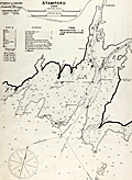 | Details | Eldridge, George W. | 1914 |
| Antique Harbor Chart of Stamford Connecticut |
|
Eldridge, George W. |
|
| 1914 |
| LOC:10 |
| $350.00 | Eldridge--George-W- | Antique-Harbor-Chart-of-Stamford-Connecticut | Early 20th-century antique nautical chart of Stamford, Connecticut harbor and channels ca. 1914. Noted features and locations include Stamford Yacht Club House, Shippan Point, Peck's Point, Davenport Point, Pine Island, and Stamford Light. Printed on strong, watermarked paper "Resolute Ledger".
<br></br>
Much useful information including numerous rocks, soundings, anchorages, ranges, buoys, and bottom composition near Stamford are presented by Eldridge in a clear graphic style that would have been appreciated by mariners. For instance, this chart of Stamford Ct. is printed with bold black coastal outlines that would have been much easier to read under poor lighting conditions. Lighthouses, buoys, and other aids to navigation are highlighted in red or green.
<br></br>
Published by Wilfrid O. White of Boston, Massachusetts. White was Eldridge's son-in-law who continued to sell Eldridge's charts after his death until 1932.
<br></br>
Attribution reads: 'AUTHORIZED and PUBLISHED By Geo. W. Eldridge, Kelvin & Wilfrid O. White Co. 112 State Street, Boston. 38 Water Street, New York '. Number 10 in Eldridge's book of harbor charts. |
| 847 |  | Details | Eldridge, George W. | 1917 |
| Antique chart of Block Island Sound between Montauk and Martha's Vineyard |
|
Eldridge, George W. |
|
| 1917 |
| LOC:1409 |
| $600.00 | Eldridge--George-W- | Antique-chart-of-Block-Island-Sound-between-Montauk-and-Martha-s-Vineyard | Antique nautical chart by Eldridge of Block Island Sound with portions of coastal New York, Connecticut, Maine, Massachusetts, and Rhode Island. Coverage on this maritime chart of New England includes Montauk Point on Long Island, Gardiners Island, Fishers Island, Block Island, Point Judith, Cuttyhunk Island, and Nashawena Island. Towns include: New London, Connecticut; Stonington, Maine; Newport, Rhode Island; and Westport Point, Massachusetts. Inset plan of Block Island Harbor at upper center. Near Newport, Rhode Island chart detail includes the Brenton Reef Light Ship, Fort Adams, Beavertail Point, Coasters Harbor Island, and Rose Island.
<br></br>
Newport, Rhode Island has a long association with sea trade, piracy, and naval history. During the colonial era the major financial activity in Rhode Island was the slave trade and Newport was at the center of that commerce. One of the first outward American acts of defiance against the British government took place on the north end of Goat Island in Newport harbor. In May, 1769 a mob of Rhode Islanders sank and burned the British revenue sloop HMS Liberty in retaliation for British seizures of American vessels.
<br></br>
This antique chart was produced under the name of George Washington Eldridge (1845-1914) who carried on the business of chart publishing after the death of his father George Eldridge in 1900. It was published by Wilfrid O. White of Boston, Massachusetts. White was Eldridge's son-in-law who continued to sell Eldridge's charts after his death until 1932.
<br></br>
Guthorn explains the attraction and value that Eldridge's charts held through the years for seafarers who depended on them: <div class="indenttextblock"> "They survived because of good design, simplicity, omission of extraneous shore topography, legible soundings, notes and the use of compass courses only ( Guthorn, Peter. United State Coastal Charts: 1783 - 1861. Exton, Pennsylvania. 1984. p. 12. )." </div> |
| 608 |  | Details | Eldridge, George W. | 1924 |
| Massachusetts Bay and Coast from Chatham to Gloucester |
|
Eldridge, George W. |
|
| 1924 |
| LOC:0 |
| $0.00 | Eldridge--George-W- | Massachusetts-Bay-and-Coast-from-Chatham-to-Gloucester | SOLD
<BR> </BR>
Extra-large old nautical chart of <b>Cape Cod</b>, Massachusetts Bay, and the Massachusetts coast from Chatham north past Boston. Created by George Washington Eldridge (d. 1914) and published by Eldridge's widow, Sydna Eldridge a decade after George's passing. Coverage includes the coastal margins near the towns of Provincetown, Truro, Wellfleet, Brewster, Yarmouth, Plymouth, Scituate, Cohasset, Marblehead, Salem, Gloucester, and the town and harbor of <b>Boston</b>, Massachusetts.
<br></br>
Printed on thin, rolled paper, this nautical chart was probably destined to be backed with linen which would have provided the strength needed to withstand rigors of day to day use at sea. This chart is a survivor, perhaps one of the last copies of a chart whose origins extends back at least 30 years.
<br></br>
G.W. Eldridge was the son of well-known cartographer and hydrographer George Eldridge, whose first charts were of the area off Chatham, Mass. including Pollock Rip and the sandbars from Stone Horse to Handkerchief Shoals<sup>1</sup>. This chart carries a warning notation at the Chatham Bar: <dir class="indenttextblock" > "Chatham Bars are rapidly extending seaward and should be approached with caution at night."</dir>
<br>
Copyright Sydna Eldridge, Vineyard Haven, 1924. Published by Wilfrid O. White, Boston Massachusetts in 1924. Drawing by A.N. Houghton, Boston, Mass.<br></br>
<sup>1</sup> (Nickerson, Joseph A. and Geraldine Nickerson, "Chatham Sea Captains in the Age of Sail". Google Books. 2008.) |