| | Thumbnail | | Creator | Date | Title / Author / Date / Location | Price | | | Description |
| 5456 | 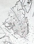 | Details | Elliot and Ames | 1861 |
| Antique Civil-war era map of Charleston Harbor and fortifications |
|
Elliot and Ames |
|
| 1861 |
| LOC:53 |
| $0.00 | Elliot-and-Ames | Antique-Civil-war-era-map-of-Charleston-Harbor-and-fortifications | Sold
<br></br>
Rare early Civil War era map of Charleston Harbor, South Carolina and vicinity with local harbor defenses including a "Battery Erected By Secessionists" at the north side of Morris Island. Compiled by Elliot & Ames from U.S. government surveys, the plan was published by A. Williams & Co., Boston in 1861. Lithographed by C.D. Andrews.
<br></br>
This map was published in the same year as the bombardment of Fort Sumter on April, 12th, 1861. It depicts the main ship channel into Charleston, at the confluence of the Ashley and Cooper Rivers and shows Hog Island and Sullivan Island, many channels and low-water marks, and a street map of the city of Charleston, South Carolina. South Carolina was the first state to secede from the Union in December, 1860. |