| | Thumbnail | | Creator | Date | Title / Author / Date / Location | Price | | | Description |
| 4833 | 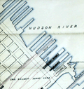 | Details | Erie Railway Company | 1870 |
| Rare manuscript Erie Railway trace map Jersey City |
|
Erie Railway Company |
|
| 1870 |
| LOC:53 |
| $500.00 | Erie-Railway-Company | Rare-manuscript-Erie-Railway-trace-map-Jersey-City | One-of-a-kind post civil-war inked manuscript map of the Erie Railway Company and Long Dock Co. property [1] in Jersey City, New Jersey from 1870. On surveyor's tracing cloth, this artifact was likely used as the master copy for producing other cyanotype (blueprint) maps [2].
<br></br>
The map extends from the Hackensack River to the Hudson River south of 11th Street, including land now occupied by the Holland Tunnel approaches. To the south, the map ends roughly at Newark Avenue.
<br></br>
Shows the Long Dock Company Tunnel (Bergen Tunnel) built in 1861. The new tunnel was used by the Erie Railway to reach the Pavonia Depot on the Hudson River. Copious explanation of the lands, railroads, docks and piers; and improvements. Scale 400 feet to one inch. Title states "Made in compliance of an Act of the Legislature of the State of New Jersey. Approved March 17, 1870.
<br></br>
Made during a period of great change and great fortunes made by railroad speculators such as Jay Gould who attempted to take control of the Erie Railway in 1873. In fact it was just one year before this map was made that Gould and partner James Fisk caused financial devastation with a scheme to control the gold market.
<br></br>
[1] The property of the Long Dock Company was operated by Erie Railway Company and its receivers Jan. 1, 1861 to May 31, 1878. The Long Dock Company was incorporated by special act of the State of New Jersey in 1856,for the purpose of constructing a railroad within the limits of Hoboken and Jersey City, N. J. with docks, piers, and bulkheads and establish a ferry at or near Pavonia Avenue, Jersey City, N. J.<br/>
[2]A blueprint was created by overlaying the traced map (as we have here) onto a piece of paper treated with a photo-sensitive compound. After exposure to sunlight the paper was washed and dried with the end product a blue negative copy of the trace. |