| | Thumbnail | | Creator | Date | Title / Author / Date / Location | Price | | | Description |
| 4875 | 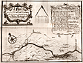 | Details | Eyes, John | 1758 |
| River Calder between Sowerby and Halifax |
|
Eyes, John |
|
| 1758 |
| LOC:88 |
| $250.00 | Eyes--John | River-Calder-between-Sowerby-and-Halifax | Map of the course of the Calder River between Sowerby Bridge and Halifax Brooks mouth by John Eyes. January, 1758. Includes towns and hamlets of Mermaid and Norland Town.
<br></br>
Now part of the Calder and Hebble Navigation suitable for vessels up to 14 feet in width.
<br></br>
John Eyes was a Liverpool surveyor, active 1740-1758, well known for his work surveying the Dee estuary. Eyes' four charts of the Lancashire coast from 1738 are said to be the first charts to show Greenwich as the Prime Meridian. (Skempton, Alec ed. Biographical Dictionary of Civil Engineers, Vol 1. p.220)
<br></br>
J. Evans sculpt. Liverpool. |