| | Thumbnail | | Creator | Date | Title / Author / Date / Location | Price | | | Description |
| 613 | 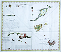 | Details | Fahlberg, Samuel | 1792 |
| Chart of Saint Barthelemy, St. Martin and Anguilla |
|
Fahlberg, Samuel |
|
| 1792 |
| LOC:51 |
| $22,500.00 | Fahlberg--Samuel | Chart-of-Saint-Barthelemy--St--Martin-and-Anguilla | Exceedingly rare original antique chart of the Caribbean islands of <b>Anguilla, St. Barts, St. Martin, Dog Island, and Prickly Pear Island</b> by Swedish cartographer and physician <b>Dr. Samuel Fahlberg</b> (1758-1834) . This beautifully engraved chart may well be the only available small-scale sea chart of these three Caribbean Islands by a Swedish cartographer.
<br></br>
No record of a sale of this chart in the Antique Map Price Record database (200K map sales since 1982). Faint pencil notations and a course plot into the harbor at Saint Martin indicate that this chart was used at sea. <br></br>
Fahlberg moved to St. Barthelemy (St. Barts / Barth) as a physician in 1784 after the island was ceded to Sweden by France. In 1803 Fahlberg was named Director of Survey of St. Barts; he thoroughly mapped the island for the Swedish West India Company ( Svenska Vastindiska Kompaniet ) <sup>1</sup>.
<br></br>
Contains a detailed inset of Gustavia on St. Barths titled "Speciale-Chart ofver Inloppet och Hammen Carenage samt Staden Gustavia. According to the John Carter Brown library: "The main town on Saint Barthélemy was called Le Carenage by the French, but renamed Gustavia by the Swedes when the island was given to the Swedes by Louis XVI in return for free port rights to Gothenburg, Sweden". A 'carenage' is an area typically along a shallow beach where wooden ships without access to a drydock could be beached at high tide, or careened, in order to clean, caulk, and repair their hulls.
<br></br>
On chain-laid paper with watermark: "C & I Honig". Engraved by the Swedish chart maker Erik Akerland (1754–1832). Stockholm: 1792. Text is in Swedish. <br></br>
<sup>1</sup> Reinhartz, Dennis. "The Caribbean Cartography of Samuel Fahlberg". History of Cartography Symposium. Springer. 2012. http://www.springer.com/978-3-642-19087-2. |