| | Thumbnail | | Creator | Date | Title / Author / Date / Location | Price | | | Description |
| 5176 | 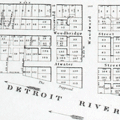 | Details | Farmer, John | 1831 |
| Plat of the City of Detroit by John Farmer 1830 |
|
Farmer, John |
|
| 1831 |
| LOC:10 |
| $250.00 | Farmer--John | Plat-of-the-City-of-Detroit-by-John-Farmer-1830 | Plat of the City of Detroit, a fine steel-engraved cadastral plan of Detroit, Michigan drawn by John Farmer. The map of Detroit was issued by the US Government in their 'Report of Public Lands' for 1831.
<br></br>
Lacking the volume numbers and printer's attribution to Bowen and Co. that characterize the later edition of 1860, thus 1830. 21st Congress, 2nd Session, Washington, DC.
<br></br>
By cartographer John Farmer (1798-1859 ). In 1844 Farmer published his best known work- "The State of Michigan and the Surrounding Country". Extremely detailed, the map quickly became so popular with the public that prices for used copies of Farmer's map soon exceeded the list price. |